The Amazon Sea ñ The Sea East
(A Matter of Perspective)
by Don R. Hender
 At the time of this article's first writings, I worked at Dugway Proving Ground (1994-2001), an army installation in the western
salt flats desert of Northern Utah. It is in the middle of nowhere. From I-80
you take the road that 'runs up' Skull Valley 'southward' for around 40 miles before you
reach Dugway. A few ranch houses, Iosepha, a one time Polynesian/Mormon
settlement, and the small Goshute Indian reservation is about all the
civilization you come across besides the wild life on the open range. The
existence of an Amazon Sea is like riding the Skull Valley road to Dugway, if
you drive the road long enough, it is not a matter of ëifí, it
is only a matter of ëwhení before you hit an animal with your
car along that lonesome stretch of open range. Likewise, the existence of an
Amazon Sea in the great Amazon Basin is not a matter of ëifí there ever was
an Amazon Sea. Science will concede that many years ago the Amazon Basin was
a sea, which they like to point out, had an outlet to the Pacific Ocean. That
outlet, I'd say was in the Lake Titicaca region, where there are many sea
like features of that high altitude lake today.
At the time of this article's first writings, I worked at Dugway Proving Ground (1994-2001), an army installation in the western
salt flats desert of Northern Utah. It is in the middle of nowhere. From I-80
you take the road that 'runs up' Skull Valley 'southward' for around 40 miles before you
reach Dugway. A few ranch houses, Iosepha, a one time Polynesian/Mormon
settlement, and the small Goshute Indian reservation is about all the
civilization you come across besides the wild life on the open range. The
existence of an Amazon Sea is like riding the Skull Valley road to Dugway, if
you drive the road long enough, it is not a matter of ëifí, it
is only a matter of ëwhení before you hit an animal with your
car along that lonesome stretch of open range. Likewise, the existence of an
Amazon Sea in the great Amazon Basin is not a matter of ëifí there ever was
an Amazon Sea. Science will concede that many years ago the Amazon Basin was
a sea, which they like to point out, had an outlet to the Pacific Ocean. That
outlet, I'd say was in the Lake Titicaca region, where there are many sea
like features of that high altitude lake today.
Thus the fact of an Amazon Sea is not a matter of if there was one. It is just
a matter of when did it exist? Science is also coming up with various
evidences of a massive, possibly world wide, flood which they stipulate
happened many years ago. Science likes to put these events thousands upon
thousands of years past and out of the range of Biblical history. Those of us
who believe the Bible believe the world wide flood of Noah happened only 4 to
5 thousand years ago and not thousands upon thousands of years ago. Likewise,
I believe the Amazon Sea existed much more recently than science allows. I
believe it existed up until just about 2000 years ago when the catastrophic
events of the destructions recorded in the Book of Mormon at the time of the death
of Christ, began to close up and fill up the Amazon Basin to the extent that
there is but the worlds most voluminous river there today. And I believe that
it was the Sea East of the Book of Mormon lands. Now, since I believe in
events like Noah's flood, Peleg's division of the earth in his days, and the
bring back of the Lands together in the days of Christ's Second Coming, a
belief that the Amazon Sea was of recent date and the Book of Mormon's East Sea
is not a large jump either. So slowly we turn.
The evidences for an Amazon Sea:
Direct evidences
Science says there was once an Amazon Sea.
Orinoco - Amazon natural canal that is still a water route and division of
the lands today.
 Blue water, black water, and muddy brown water which attest of three differing
land bodies surrounding the Amazon Basin.
Blue water, black water, and muddy brown water which attest of three differing
land bodies surrounding the Amazon Basin.
Is it a sea or not - exclamation of the Spanish explores first sighting of it
some 500 years ago.
The two large mid-Atlantic Islands of the Phoenicians - Iron Island.
The salt rings on the mountains around Titicaca.
The general nature of the massive Andean Uplift
Flamingo at 10,000 feet
The sea like features of Lake Titicaca and the Amazon including plants and animals
The skeletal remains of sharks and such found inland in the Argentina regions
by Darwin
The 30% larger lung capacity physical adaptation of the Peruvian Indians
having to physically adapt due to their lands being raised up significantly
elevation wise during their habitation of the land.
Remains of ancient terraced corn fields at elevations above which it is
impossible for corn to germinate also attesting to the rapid uplift of the
land during the destruction of the land colliding at the death of Christ.
Etc. Etc.
As it is said, it is not a matter of if. It is only a matter of when.
Scriptural, Prophetic, and Historical Evidences
Joseph Smith's statement as recorded in the Teachings of the Prophet Joseph
Smith page 267 about Lehi landing a little south of the Isthmus of Darien, which I
believe.
The Book of Mormon stating that Lehi was brought to the land South, and if
Lehi's landing was at the Isthmus of Darien, everything south of that site
would be part of the land south.
Big Warrior stating in 1822 that his ancestral people first landed at the
Isthmus of Darien, having come from the east (Asia/Asia Minor).
George Reynold's statement that the river Sidon was the Magdalena river.
Indirect evidences, collaborative evidences, deduced evidence pieces
of the Jigsaw Puzzle:
If Colombia was/is the land of Zarahemla, then the whole of South America, as
we know it today, could not have been the same in the Book of Mormon times.
It is just too wide to consider that all the way to the Atlantic as the width
of the land back in the Book of Mormon times. Therefore there had to be a sea
in the midst of what we know as South America today. There just had to be an
'Amazon Sea East' dividing, via the basin of the Amazon, South America into
Islands. The most western one being Jacob's Island, the Book of Mormon
Island.
The Orinoco plains become the Plains of Nephihah of the Book of Mormon and
they must end at a sea's beginning at about 300 feet above sea level in
relation to their advanced altitude today.
Now the question of ëWhen?í
The question of ëOutlets.í
How was the Amazon Sea made into a river?
The Land South ñ Jacobís Island
And now I, Jacob, speak unto you . . . we are upon an isle of the sea. (2 Nephi 10:1&20)
In Nephi's second book, Jacob, Nephi's brother speaks to the people of Nephi.
His sermon is doctrinally based and one of the doctrines is that when Isaiah
was speaking about the blessings of those who are upon the islands of the sea,
Isaiah was speaking of the Nephite people as they were upon an isle of the
sea. Now there has been speculation about what constitutes an 'island'
scripturally. Some have said that other than the main old world 'continent,'
of which Jerusalem and the connecting African, European, and Asia lands are
all part of, is considered one land or continent. All else in the world was
considered islands. Thus by
default Jacob concluded that they were upon an island of the sea scripturally,
as they were no longer on the adjoining old world lands. Another interpretation
is that Jacob knew literally that they were upon an island of the sea and not
on a
continent. This seems contradictory at first assessment, as all the lands of
the main lands of North and South America are continents today. And here in
lies the key in my opinion. Today they are of the size of continents. In
Jacob's day, the land south upon which Lehi landed was not the size of the
South American continent as we know it today. It was one of a number of large
islands that would 'collide' and become one beginning with the destruction at
the time of the death of the Savior. And what the major dividing body of
water was, that divided the lands, was the Amazon Sea or the Sea East.
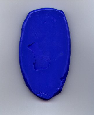
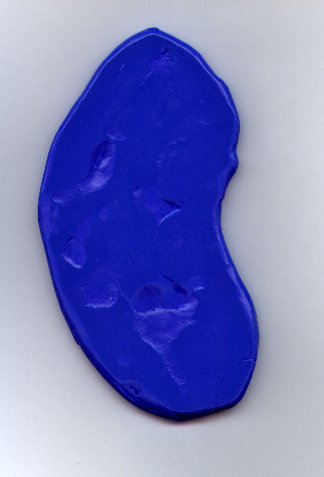
In conjunction with having carpal tunnel, I was given a piece of blue putty to exercise by hands, fingers, and wrists with. I would like to use my blue putty, hand, fingers, and wrist to talk about what happened to Jacobís Island.
They say that when a land slide happens, when a volcanic pyroclastic
outflow occurs, when an earthquake occurs, or when shifting of the earthís
crust occurs, that the land flows, rocks and all, in a manner similar to
liquid. My blue putty does somewhat the same. I can shape it into a column
and stand it up, but it will begin to flow down and tilt as gravity pulls on
it. If I lay it across something that is raised, it will flow down around it. It will seek to conform to the shape of what it is laid on. Now land doesnít act exactly like putty, but there are similarities. The forces of geology and plate tectonics form and shape the land. There is the gravity and the moving forces that make the lands conform.
Jacobís Island, the Land South could be considered as a fat column of land
running north and south for much of the history of the Book of Mormon before the time of Christís death. To the immediate east was the Sea East, the Amazon Sea. Further east where the two large islands that the Phoenicians report which broke from the coast of Africa and were moving at a much more rapid rate of travel than today, being pushed by the Mid-Atlantic volcanic rift. They had been in motion since the days of Peleg when the earth was divided. But they had not collided any sizable land mass, tectonic plate to the west that had as of yet impeded their motion enough to nearly bring it to a stop. Yes the motion was slow, but it was measured in feet per year, rather than the inches we measure it in today.
When the plates from the east, the two African brake off islands met
Jacobís
Island, of the west which was the tail of the Land of North America, a great catastrophic land collision occurred. It is described in the Book of Mormon in 3rd Nephi. The details of this are presented in another article. What happened to Jacobís Island was the it was bent by the collision, the crust of the earth was broken up, and what is today Peru and Colombia, the wedges of much volcanic eruption and commotion raising up and forming much of the bend in the land as it is today around Ecuador.
This can be visualized in three ways. First the blue putty. Now take the fat column of blue putty and bend it in on the one side. Be very careful so that the one side (the eastern side) does not lose any land length other than it is bent. Then the other side (the western coast) must expand its land length to accommodate the bending in at the east. Now your putty looks like Colombia bent slightly to the northeast on top, Ecuador in the middle but mostly on the west coast, and Peru on the bottom tilted slightly to the northwest. That is one visualization.
You can do pretty much the same with your left wrist Close your hand in a
lose fist and position your thumb facing you, the folded fingers being no
longer visible as covered by your thumb. A portion of you arm just before your
wrist on up to the end of your fist can be considered Jacob's Island before
the collision with the bending of the land it caused. Now hold your wrist
straight between the arm and hand in a straight line. Then bend your fist in
toward your inner arm. Here the inner portion of the wrist will contract,
which is actually the weakness of this visualization because the eastern
coast of Jacobís Island did not contract, it just bent. But you can readily
see that the out side of the wrist did expand. In fact if you had place one
dot, representing the City of Zarahemla on the back of your hand, and another
dot, representing the City of Nephi, on the back of your arm just before the
wrist, when you bent your wrist the distance between the two would be
significantly increased. If you would measure the before and after distances,
you could likely calculate up to a 30% increase in the distance between your
two cities, I mean dots.
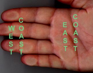
Now for a third way to visualize this. This visual can be very specific
and applied to just the area of the land where it is most bent. That would be
namely along the west and east coasts of Ecuador, southern Colombia and
northern Peru, though there isn't much of an east coast of Ecuador. Now
Hold you hand palm down as shown in the figure to the left. Your fingers are
extended straight but closed together. The palm of your hand represents
the East Coast of the wilderness lands between the lands of Zarahemla and
Nephi or of Ecuador. The fingers represent the West Coast of that same region.
For the most part when the fingers are closed together the land is about
equal in distance on both
 the east and west coasts, cutting off the tips of the fingers. Please do not
do this really. Now expand the fingers apart. The distance along the arch of
the spread fingers is now significantly of greater length than they were
before and nearly double the length of the palm on the other side of the
hand.
the east and west coasts, cutting off the tips of the fingers. Please do not
do this really. Now expand the fingers apart. The distance along the arch of
the spread fingers is now significantly of greater length than they were
before and nearly double the length of the palm on the other side of the
hand.
You're right! There has to be something filling in between the
fingers to still make it all land and not let the ocean rush in. Can you
guess what? Its not hard. If the west coastís earthís crust broke apart
from the force of the collision of the African Island land plates bumping
into the east coast as did my fingers, the broken crust would let volcanic
magma and explosions
from below the earthís crust begin to take effect and fill in the broken gaps.
Now the question is, 'Is the land of Ecuador, southern Colombia, and
northern Peru full of Volcanoes?' The answer is yes!
 Now Iíve painted you
three graphic visualization with blue putty, my hands and fingers, and your
wrist. And they say a picture is worth a thousand words. So now I have a
few pictures to further share with you. Sometimes things are in the eyes of
the beholder and sometimes it is just in the way you look at a thing. First
Iíd like to present a picture of South America in relief showing the Amazon
Basin the way you would be familiar with seeing it. You can see the Amazon
River cutting in from the east and you can see the cordilleras of the Andes
all along the bowed portion of the west coast where Colombia, Ecuador, and
Peru would be. The three branches of the western, central and eastern
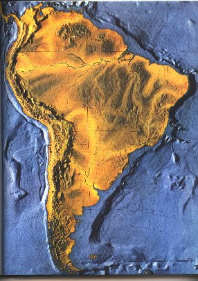
cordilleras are in the north where Colombia is are slanted northeast. The Andes Mountains in Peru are slanted to the northwest. And in Ecuador, the volcanic infested mountains have remained running north and south. If you use your imagination, you can almost see where the previously visualized bend has occurred as the coast bows out into the Pacific Ocean. You can also make out by the darker colored mountains where the two islands, which came from Africa, might be shaped and formed. This is roughly the Brazilian and Venezuelan regions. The yellow light colors represent the low lands where the Orinoco River and Amazon river cut into the land from the north and the east respectively. Now Iíve painted you
three graphic visualization with blue putty, my hands and fingers, and your
wrist. And they say a picture is worth a thousand words. So now I have a
few pictures to further share with you. Sometimes things are in the eyes of
the beholder and sometimes it is just in the way you look at a thing. First
Iíd like to present a picture of South America in relief showing the Amazon
Basin the way you would be familiar with seeing it. You can see the Amazon
River cutting in from the east and you can see the cordilleras of the Andes
all along the bowed portion of the west coast where Colombia, Ecuador, and
Peru would be. The three branches of the western, central and eastern
cordilleras are in the north where Colombia is are slanted northeast. The Andes Mountains in Peru are slanted to the northwest. And in Ecuador, the volcanic infested mountains have remained running north and south. If you use your imagination, you can almost see where the previously visualized bend has occurred as the coast bows out into the Pacific Ocean. You can also make out by the darker colored mountains where the two islands, which came from Africa, might be shaped and formed. This is roughly the Brazilian and Venezuelan regions. The yellow light colors represent the low lands where the Orinoco River and Amazon river cut into the land from the north and the east respectively.
Now before I show you the next picture from a different perspective, let
me just point out that this first picture may give a bit of a poorer picture
of what is highland and what is lowland. All the way into the interior of South America the lands remain very low in comparison to sea level. All the way to the base of the Andes or the Cordilleras of western South America are lowlands. How low you may well ask? Consider the length of a football field, 100 to 120 yards (end zones included), 300 to 360 feet. Most of the lands of the Amazon basin are no further above sea level than that. And it is a wet marshy type land where the rivers meander through the basin with much of what appears to be land actually afloat on the water in the marshes.
 Now Iím going to have
you
look at South America from the east, an eastern perspective. It will run west
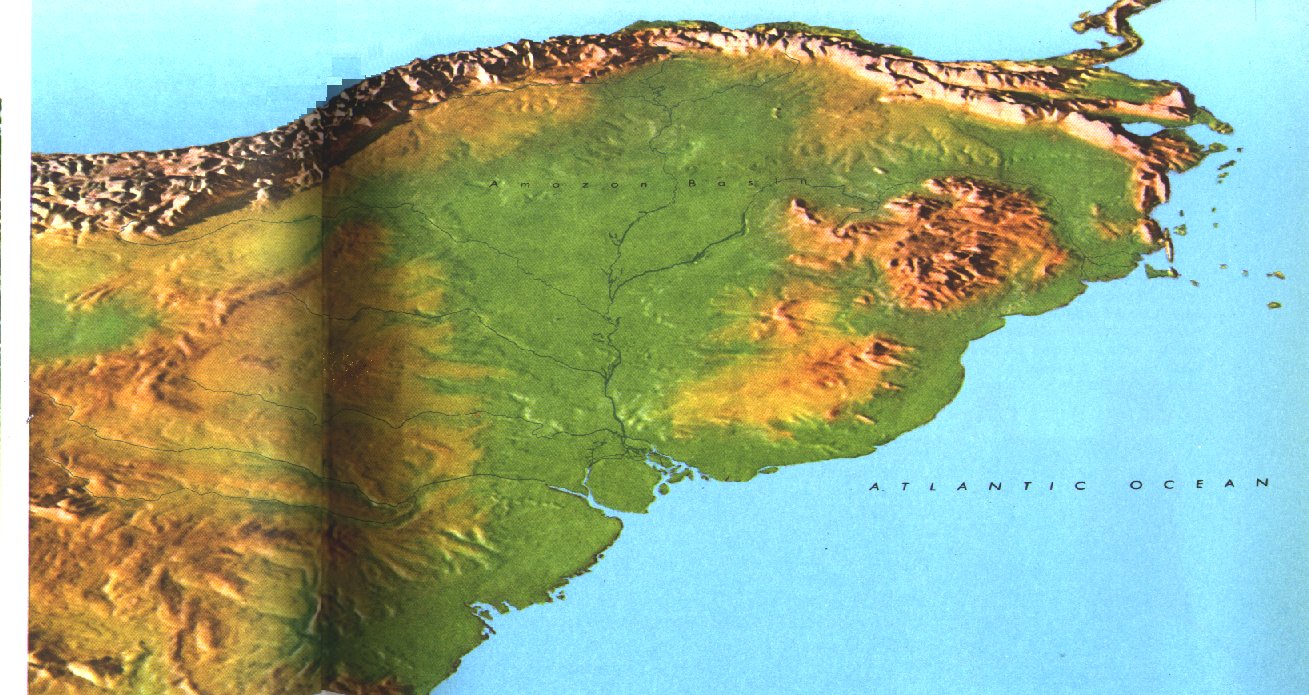
to east instead of the more familiar north to south of the first picture. And this picture shows the Amazon basin in green, which is a fair representation of the size of the Great Amazon Basin. Can you make out the Panama region in the upper right trailing off into Central America? Do you see how the Amazon Basin pushes in on the center of the western coast and bows Ecuador out? Do you see the three branches of the northern Cordilleras of Colombia? Do you see the grand heights of the Andes of Peru? Notice just how close the Amazon Basin presses in on the Andes from Colombia all the way down Peru. For the most part, these green basin lands are only a few hundred feet above sea level. Notice also how the Orinoco River valley or basin cuts across between Colombia and Venezuela. Now consider this, what if the Amazon and Orinoco basins where some 500 feet lower? What would the picture look like if what was green was painted light sea blue? It is coming up. Now Iím going to have
you
look at South America from the east, an eastern perspective. It will run west
to east instead of the more familiar north to south of the first picture. And this picture shows the Amazon basin in green, which is a fair representation of the size of the Great Amazon Basin. Can you make out the Panama region in the upper right trailing off into Central America? Do you see how the Amazon Basin pushes in on the center of the western coast and bows Ecuador out? Do you see the three branches of the northern Cordilleras of Colombia? Do you see the grand heights of the Andes of Peru? Notice just how close the Amazon Basin presses in on the Andes from Colombia all the way down Peru. For the most part, these green basin lands are only a few hundred feet above sea level. Notice also how the Orinoco River valley or basin cuts across between Colombia and Venezuela. Now consider this, what if the Amazon and Orinoco basins where some 500 feet lower? What would the picture look like if what was green was painted light sea blue? It is coming up.
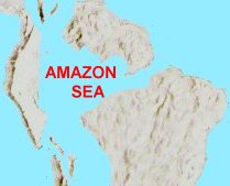
 Now with a few
liberties, here it is, the Amazon Sea, the Sea East of the Book of Mormon with
its outlet to the Pacific Ocean in the regions of Lake Titicaca.
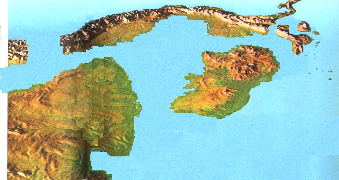
You see the two large Islands of the Phoenician description in the foreground. You see in the land of Columbia the three branches of the Cordilleras. Between the eastern Cordillera and the Middle Cordillera would be the Sidon River valley where the Provincial Land of Zarahemla would be. In the next valley away, the Cauca, between the Western Cordillera and the Middle Cordillera, would be where the City of Ammonihah and Noah would be with the Lands of Melek being in the upper regions of that valley. This would be the parallel valley that the Limhiís expedition took by mistake and continued on up into the Land of Desolation where they found the 24 golden plates of Ether. The brown flat land of Colombia before the eastern Cordillera would be the Orinoco Plains of Colombia today. The Book of Mormon refers to these plains as the Plains of Nephihah. That the Pacific outlet of the Amazon Sea cuts through the Lake Titicaca region is a matter presented elsewhere, as is how the sea continues on into Argentina just out of the picture to the left or south. Now with a few
liberties, here it is, the Amazon Sea, the Sea East of the Book of Mormon with
its outlet to the Pacific Ocean in the regions of Lake Titicaca.
You see the two large Islands of the Phoenician description in the foreground. You see in the land of Columbia the three branches of the Cordilleras. Between the eastern Cordillera and the Middle Cordillera would be the Sidon River valley where the Provincial Land of Zarahemla would be. In the next valley away, the Cauca, between the Western Cordillera and the Middle Cordillera, would be where the City of Ammonihah and Noah would be with the Lands of Melek being in the upper regions of that valley. This would be the parallel valley that the Limhiís expedition took by mistake and continued on up into the Land of Desolation where they found the 24 golden plates of Ether. The brown flat land of Colombia before the eastern Cordillera would be the Orinoco Plains of Colombia today. The Book of Mormon refers to these plains as the Plains of Nephihah. That the Pacific outlet of the Amazon Sea cuts through the Lake Titicaca region is a matter presented elsewhere, as is how the sea continues on into Argentina just out of the picture to the left or south.
Now there is Jacobís Island with a Sea West, a Sea North, a Sea East, and
a Sea South. Jacob, being a young and adventurous man may well, or most
likely did see all of these four seas firsthand during his lifetime. And
thus he would have firsthand knowledge concerning the nature of the land on
which they had landed. With the exception of the narrow neck of land, that
he might of missed or which could of even been inundated by the storms of El Nino,
Jacob knew that indeed they where upon an Island of the Sea.
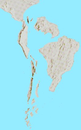
Now one last picture, turning the image right side up, northward, again.
Can you see South America being formed in this picture from the days of Peleg
when the earth was divided? Can you see Jacobís Island? Can you see the
pending catastrophic destruction coming when these tectonic plates would
eventually collide at Jesusí death as recorded in the Book of Mormon? And can
you see the great Amazon Sea as being the Sea East of the Book of Mormon?
Before We Leave
Before this discussion is left, besides 'Jacob's Island', there are are a
number of contributing features and circumstances which are also suggestive
upon this matter.
I. Pantanal and Darwin's Sharks
II. Amazon Basin
III. The Orinoco Floods and Natural Canal
IV. The Andean Uplift
- a. ancient corn fields above where corn can grow
- b. Titicaca's natural causway to the Pacific
- c. Native Peruvians' unique expanded lung capacity
- d. The many volcanos 'active' and 'dormantly active' of the Ring of Fire of the
mountain ranges of the western Americas
V. Climate Change Threatens Return of Amazon Sea
VI. The Rivers that Run Black, Blue and Brown in to the Amazon
VII. Spanish Explorer's First Impression of the Amazon - 'Sea or not?'
VIII. Book of Mormon Massive Land Changing Destruction
IX. Biblical timing of the division of the land in Peleg's day
|