Luck, Lucke, Colleton, Colington Island
A History of the Origin of North Carolina
prepared by Don R. Hender
Since the first Virginia Charter of
April 10, 1606, Virginia, the Colony thereof, has been defined as 'being all
along the sea coastes between fower and thirtie [34] degrees of northerly
latitude from the equinoctiall line and five and fortie [45] degrees of the
same latitude and in the maine lande betweene the same fower and thirtie and
five and fourtie degrees, and the ilnandes thereunto adjacente or within one
hundred miles of the coaste there;'. The second Virginia Charter of 1609 added
the significant phrase concept of 'from sea to sea' which extended the
Colony from the Atlantic Coast to the Pacific Ocean in its Land grant claims.
The eventful sea voyage stay upon Bermuda Island during the winter when
Virginia was going without food while those stranded on Bermuda had plenty,
gave reason to extend the southern and eastward seaward bounds to 30 to 41
degrees for 300 leagues or 1000 miles out to sea which would thereafter
include all such islands in that range including Bermuda.
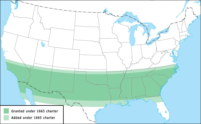
In 1629, King Charles I of England granted Sir Robert Heath (the attorney
general) the southern half of the English land in the New World cut from the
Virginia Colony lands between 36 degrees and 31 degrees north latitude from
the Atlantic Ocean to the Pacific Ocean. Under that grant the land was named
"Province of Carolina" or land of Charles. This land area included most all
that is now known as North Carolina and South Carolina. But the 'in the works'
attempts of Sir Robert at settlement failed and in the course of the English
Civil War, Sir Robert Heath was stripped of all of his possessions as a
Royalist supporter of the King. And thus the 1629 grant failed to materialize.
The 1629 grant was before its time, but as early as 1643 til 1663 and even
1665, permanant settlers from Virginia became the first in what would later
become North Carolina. Actually the very first 'Colonial settlers' came much
early in conjunction with Sir Walter Raliegh, but 'history' records their
failure to maintain a permanant English Colony. They were left unsupported for
a extended length of time, having to fend for themselves in the New World. And
that early Roanoke Island Colony became 'lost'. That is, when those from
England finally returned and attempted to find them, the colony had disapeared
from Roanoke with but one word carved into a tree, 'Croatan'. There is some
evidence and much suspecions that the few settlers who remained alive over
that time of no contact resorted to joining themselves with the Croatan
Indians for survival and withdrew to the mainland with them. It seems
regardless of any settlers who may have so survived, from the perspective of
England, the Colonial Settlement in the New World was NOT, that is the 'Colony
was Lost' as nothing remained of it in terms of an English presence.
Now some might suggest that North Carolina's History did begin with Roanoke
Island and the 'Lost Colony'. But the actual origin of the name 'Carolina'
does not historically appear permanantly associated with the land area in
enacted documentation until 1663. The then first Charter given by King
Charles II to the eight 'Lords Proprietors' concerning Carolina, was then
'Carolina' as first named after King Charles I, was in affect, as presented
on March 24, 1663 by King Charles II. That Charter established the
northern boarder of Carolina to be from the northren shore of Luck/Lucke
Island [later named Colleton Island and today bearing the name Colington
Island], along the 36 degree latitude line as was so stated in the 1629 failed
grant to Sir Robert Heath, and then of course on west until it reached the
south sea [that is the Pacific Ocean]. And thence south within the 36 degree
border to 31 degrees north latitude to the south, which matched exactly that
land range which had one time been granted to Sir Robert Heath in 1629 and
that was and is the direct source of the same border pronounced again in 1663.
And this though some have fancied, imagined and fictionalized some other self
innovated statements relative to that northly border. Next, over two years
later and under some persuasion, on June 30, 1665, that north boundry would be
revised in a new Charter to 'about' 36 and a half degrees or 30 added minutes,
moving it some 35 miles further north and also further south to 29 degrees
northern latitude. The following map depicts that Charter revision.
The name of Luck/Lucke Island was changed to Colleton Island, Colleton being
the last name of one of the Lords Propietors. A number of historical maps
can be found which have the location of that Island during the mid 1700s and
a little modern tourish map, though not exactly accurate, depicts the modern
named Island [Calington] nicely to the point in relation to Albemarle Sound.
|
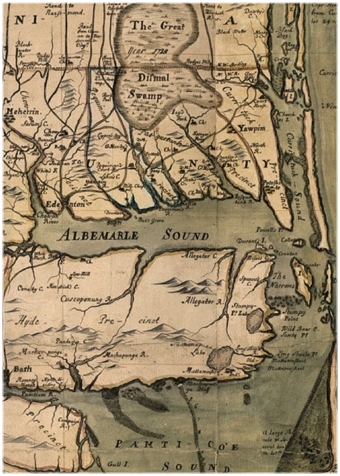 This 1737 map shows Colleton I. north of Roanoke I. at Albemarle Sound's
mouth with a break in the outer sand banks to the sea.
This 1737 map shows Colleton I. north of Roanoke I. at Albemarle Sound's
mouth with a break in the outer sand banks to the sea.
|
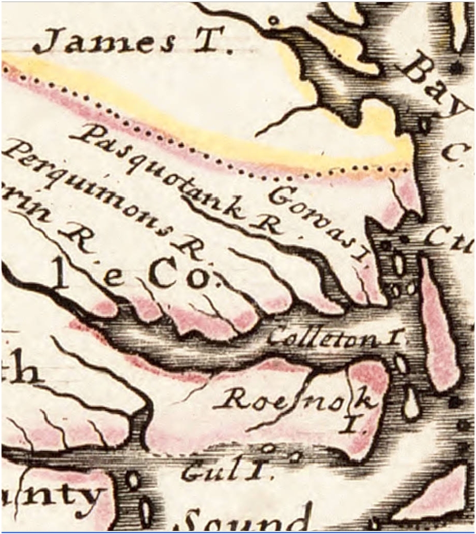 This 1729 map is 'artsy' but less accurate with 'Colleton I.' readable.
Of course Roenok I./Roanoke I. refers to the larger Island south of Colleton I.
and not to the mainland it is written on, which is much of Washington, Tyrrell
and Dare counties today. The larger 'sand bars' are just that, sealevel
shifting frontage or outer banks sand bars.
This 1729 map is 'artsy' but less accurate with 'Colleton I.' readable.
Of course Roenok I./Roanoke I. refers to the larger Island south of Colleton I.
and not to the mainland it is written on, which is much of Washington, Tyrrell
and Dare counties today. The larger 'sand bars' are just that, sealevel
shifting frontage or outer banks sand bars.
|
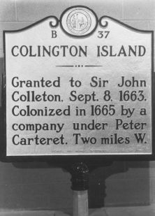
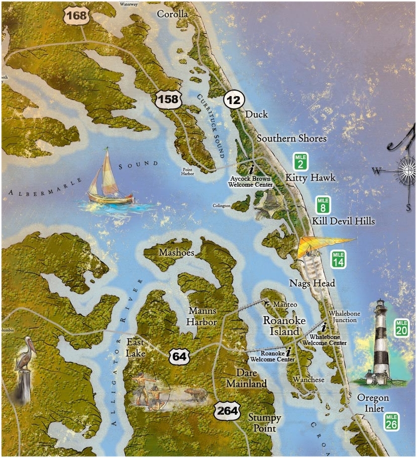 'Colington is the modern name of the small Island that is practically
swallowed up by the developed outer banks sand bars. It is virtually
attached to them. As seen by the Historical Marker below the Island is still
associated with being named after Lord Colleton. Highways and bridges
connect the islands, mainland and outer banks today.
'Colington is the modern name of the small Island that is practically
swallowed up by the developed outer banks sand bars. It is virtually
attached to them. As seen by the Historical Marker below the Island is still
associated with being named after Lord Colleton. Highways and bridges
connect the islands, mainland and outer banks today.
|
 At the age of 10, my mother and I visited family back east. We stayed with
Aunt Mae and her husband in Baltimore and then with Aunt Bertha and her
family in Norfork, Virgina. There we visited my grandmother. From thence we
traveled on down the highway which was developed connecting along the historic
outer lying sand bars, which have been expanded with peranant homes and 'summer
rentals', many on stilts along the sand bar frontage due to the tides and
threatening weather conditions. There we stayed with my cousin's family, one
of Aunt Bertha's daughters. They ran a seasonal seafood restaurant near Nags
Head and her husband captained his own commercial fishing boat to supply the
restaurant and to sell his catch. We then visited great aunt Goldie in Manteo
on Roanoke Island and we also did a genealogical tour of Tyrrell and Washington
counties where I saw the little store corner in Gumneck. My mother was born in
Gumneck where her family was living and buying some land that her father was
draining and farming. We then found near Roper in Washinton county, I believe
it was, the 'Mansion' house of Uncle Uriah Swanner where another cousin was
then living, a Jenny Lamb and her family. She directed us to what was believed
to be the home on the Swanner lands were Henry Lafayette Swanner and Nicey Ann
Quinn lived which looked like an old photo that anut Goldie had given us of
the family in front of the house back in the late 1800s.
At the age of 10, my mother and I visited family back east. We stayed with
Aunt Mae and her husband in Baltimore and then with Aunt Bertha and her
family in Norfork, Virgina. There we visited my grandmother. From thence we
traveled on down the highway which was developed connecting along the historic
outer lying sand bars, which have been expanded with peranant homes and 'summer
rentals', many on stilts along the sand bar frontage due to the tides and
threatening weather conditions. There we stayed with my cousin's family, one
of Aunt Bertha's daughters. They ran a seasonal seafood restaurant near Nags
Head and her husband captained his own commercial fishing boat to supply the
restaurant and to sell his catch. We then visited great aunt Goldie in Manteo
on Roanoke Island and we also did a genealogical tour of Tyrrell and Washington
counties where I saw the little store corner in Gumneck. My mother was born in
Gumneck where her family was living and buying some land that her father was
draining and farming. We then found near Roper in Washinton county, I believe
it was, the 'Mansion' house of Uncle Uriah Swanner where another cousin was
then living, a Jenny Lamb and her family. She directed us to what was believed
to be the home on the Swanner lands were Henry Lafayette Swanner and Nicey Ann
Quinn lived which looked like an old photo that anut Goldie had given us of
the family in front of the house back in the late 1800s.
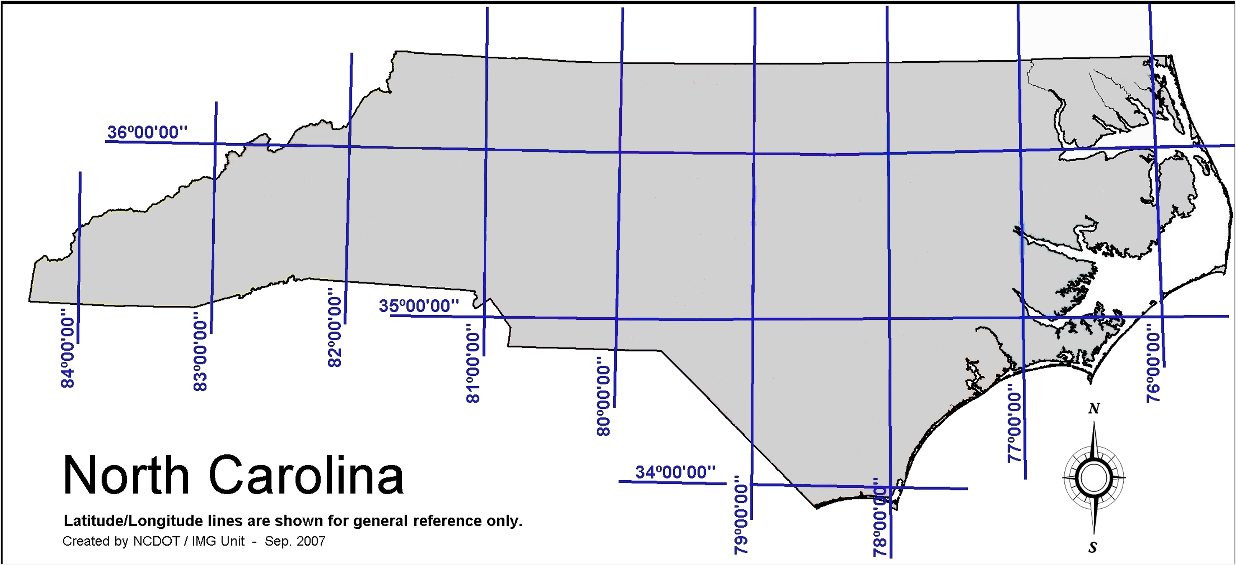
Back to North Carolina history: This next map shows how the 36th degree line
of the 1663 Charter of Carolina would have divided the Virginia Colony and
the New Carolina Colony via the Albemarle Sound from March of 1863 to June
of 1665. If it had stayed divided this way Virginia would have been on the
north shores of the sound and North Carolina would have been only on the
south shores. Can you guess why the Lords Proprietors 'landlords' as well as
the early settlers from Virgina before 1663 and before 1665 didn't want to
leave the dividing line that way but wanted it moved further north?
 The eight Lords Proprietors of Carolina, the ruling landlords of the colony,
were: 1st Earl of Clarendon and High Lord Chancellor of England England
(Edward Hyde), the First Duke of Albemarle and Master of the King's horse and
captain of his forces, (George Monck), Lord William Craven [1st Earl of
Craven], Lord John Berkeley [1st Baron Berkeley of Stratton], Lord Anthony
Ashley[-Cooper] (chancelor of the King's exchequer and later 1st Earl of
Shaftesbury), Sir George Carteret (knight and baronet and vice-chamberlain of
the King's household), Sir William Berkeley (Knight and Governor of Virgina
1640-1652 and 1660-1675) and Sir John Colleton (knight and 1st
Baronet].
The eight Lords Proprietors of Carolina, the ruling landlords of the colony,
were: 1st Earl of Clarendon and High Lord Chancellor of England England
(Edward Hyde), the First Duke of Albemarle and Master of the King's horse and
captain of his forces, (George Monck), Lord William Craven [1st Earl of
Craven], Lord John Berkeley [1st Baron Berkeley of Stratton], Lord Anthony
Ashley[-Cooper] (chancelor of the King's exchequer and later 1st Earl of
Shaftesbury), Sir George Carteret (knight and baronet and vice-chamberlain of
the King's household), Sir William Berkeley (Knight and Governor of Virgina
1640-1652 and 1660-1675) and Sir John Colleton (knight and 1st
Baronet].
The lands south of Virginia down to the sound had been explored and it was
determined that they were of better soil quality and climate for the raising
of tabaco than was Virginia. The first As early as 1643 it is recorded that settlement
by some from Virginia had began in the land regions about the [Albemarle]
sound. So for some 20 years settlers from Virginia had been living in those
lands before the Carolina Charter was granted. These Virginians had developed
some self governing organization and had began calling the various areas along
the north of the sound by the Indian names of Pasquotank, Perquimons and
Chowan.
After the first Carolina Charter of 1663, in 1664 the Propietors created
three 'counties', two of which were in the land that would become North
Carolina; and the third was in the region where South Carolina would become
located. The two 'northern' counties were Albemarle County named after the
Duke of Albemarle and Clarendon the Earl of Clarendon. As these counties
were formed in 1664, before the 1665 Charter, the original application of the
name of Albemarle County would have only been to those lands areas south of
the Albemarle Sound which also was named after the Duke of Albemarle.
It is said that the lead to push for the extention of the Carolina Charter to
include the lands north of the Albemarle sound was Sir William Berkeley, the
still active Governor of Virgina. And while the 'self governing' settlers
from Virginia would likely have some concerns about the Lords Propietors being
over them, the leadership of Virginia, Sir William Berkeley, the Governor of
Virginia had no problem with it at all, for that was what he was petitioning
for.
In June 1665, King Charles granted the extensions, both to the south into
'Spanish' Florida, as well to the north. And then the application of the name
Albemarle County was extended to the lands north of the Albemarle Sound as
well as to those of
as the north.
|
