There Is No Official Book of Mormon Map
a critical review by Don R. Hender
The Official Position of the Church of Jesus
Christ of Latter-day Saints is that there is NO Official Book of Mormon
Map that is authorized by the Church. That is, there is no offical geography
assigned to the Book of Mormon as it has not been revealed to the Church
authorities just what the precise geography of the Book of Mormon is. There
is however a 'generic' map arrangement used by the Chruch's Seminary system
for related Book of Mormon discussions. But any well schooled scholar of the
Book of Mormon will find countless 'errors' and deficientcies in that map.
And I would suppose that rather than to attempt an accurate as possible map
of the relationships of cities and lands, the Church has purposefully left
such to be as vage as possible while still providing a usable discussion map.
The Seminary Map follows:
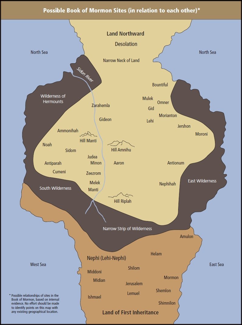
Not in an effort to purposefully 'debunk' the Seminary used map, but rather
only to demonstrate the error in presuming its absolute correctness, I will
point out a handfull of its 'deficientcies'.
- The 'capital city' of the nation and providence of Zarahemla was Zarahemla
located in the central heart (Helaman 1:18, 24, 25, 26 & 27) of the national land
of Zarahemla with all the other cities and lands of the nation of Zarahemla all
round about and not just to the west, east and south. The hill Amnihu was nearly
opposite the provincial capital city of Zarahemla on the east bank of the river
Sidon (Alma 2:15) while the city of Zarahemla was upon the west bank of Sidon.
When Alma fought and then pursued Amalici and his army they traveled south from
the hill Amnihu to where the valley of the providence and the city Gideonn was
located. This relationship is easily determined by carefully reading Alma 2 and
noting that Alma's pursuit was south toward Minon and thus also was the vally of
Gideon south of both the city of Zarahemla and the hill Amnihu. The relationship
between the location of the city of Zarahemla, the hill Amnihu, the valley of
Gideon and the city thereof, and the placement of Minon are not so clearly marked
out on the Seminary map as the scripture would so allow them to be.
- The wilderness of Hermounts was to the north and the west of the local
Zarahemla and not just to the west (Alma 2:37) and that land's description
matches that of the forest and animals found by Lehi's party as described in
1 Nephi 18:25 as also in Alma 22:31 when speaking of the land region west and
north if the providencd of Bountiful north of the province of Zarahemla and
not just west of it. This location of 'Hermounts' to the north and west would
further suggest that the Sidon river would empty to the northeast into the sea
and not through the wilderness or 'her-mounts' north and west.
- Melek and Ammonihah were to the west of Zarahemla and Sidon, being "over
into" (Alma 8:3), with Ammonihah north of Melek (Alma 8:6) yet still west of
and back "over" to the city and local provincial land of Zarahemla (Alma 15:18).
The significance of the land surface prepositions speak of traveling "over" a raised
land obstectal such as would have been noted concering a mountainous range divideing
the Sidon River Valley from the next deemable 'valley' where was located Province of Melek
and the Province of Ammonihah. Ammonihah being three days north of Melek in travel distance
which begs the question as to what mode of travel as a parallel set of valleys could mean
two rivers Sidon and perhaps Sidom both running down from the south to the sea north.
Travelling a waters route a three day journey could be as much as some 200 miles or more
'canoeing' down river at some 70 miles per day rate on a smooth river course. Lewis and
Clarke made such times of 75 miles per day down river on their return trip. Alma would have
journeyed over the central mountains to the next valley west and down into that parallel
river valley. On Alma's return to the Sidon Valley of Zarahemla he again traveled 'over'
a mountainous range.
- The defensive city of Nephihah was on a line between Moroni and Aaron and
north of the city and land of Antionum, which had seceded from the nation
of Zarahamea and had joined with the Lamanites and the nation of the lands
of Nephi. When the Zoramites joined the Lamanites they did not depart their
lands, their secession included not only themselves but their lands as well
and from that still held land of Antionum was from where, having been joined
by the Lamanites, that they had the intent of next attacking their 'poor'
Zormanite brothers who had escaped into the land of Jershon. That is Nephihah
would not have been south of Antionum, as that would make the Nephite
'defensive war of protecting Jershon' waged by Captain Moroni actually one of
agression against the Lamanites rather than one of defending the poor
Zoramites who had come to live in the land of Jershon. And the Nephite creed
was not to engage in such wars of agression.
- The Land of First Inheritance was east along the west coast of the Land of
Nephi and NOT to its south (Alma 22:28 & Mosiah 9:1). And there is no reason of
direct evidence to foster an objective opinion that the initial site of Lehi's
first landing in the new world would be the same location as their eventual
permenant settlement considered their inheritance. In fact there is some reason
to have an understanding that Lehi's troops journeyed in the land some distance
as they traveled the forest filled with animals of every kind and to such distant
places where 'ore' of every kind could be found in order to make metal tools and
even weapons out of as stipulated in the end of 1 Nephi 18 and the beginning of
1 Nephi 19, where they are part of the same continuous chapter in the original 1830
Book of Mormon.
- The north sea was not on either side of the narrow neck which had
the east sea and west sea to either side of it (Alma 22:23).
- There was a south sea though not depicted here at all (Helaman 3:8).
- It would be virtually immpossible to built a tower tall enough to over
see the land of Shemlon of the Lamanites if it were upon the west coast of
the national lands of Nephi rather than upon the east coast in the land of
their fathers' first inheritance where a careful reading of the Book of Mormon
more accurately would place it.
- Bountiful was north of Zarahemla with 'capital' parts of the land in
between (Helaman 1, particularly verse 23).
- All through the Lamanite and Nephite wars which involved the lands of Zarahamela,
never once did the Lamanites take a west coast route to attempt to get to the land
northward. They attempted going through the central valley of Zarahemla twice, once
in the days of Alma the younger (Alma 2) and once after the days of Captain Maroni during
the time of his son Moronihah. They also took the east coast route and made it just beyond
the city of Mulek approaching the city Bountiful. They even went down that parallel
river valley to the Sidon Valley when they attached Ammonihah and Noah. But they
never are recorded as having attempted the far west coast, which leaves one to consider
that some natural obstruction to a marching army stood in their way such as the vast
mangrove swamps of the western coast of the monsoonal rains all along Colombia would
present to them to march an army up that west coast region.
- Etcetera
This is not to put down the Seminary map, but rather to point out that it may
not be used to precisely locate and pin point locations of cities, lands,
land features and so on in any degree of precise relationship the one unto
the other. And this the map clearly disclaims being able to being rationally
identifiable with any exiting geographical locations of today.
Personally from the study I have done, one must truely consider that the
Book of Mormon lands before the great destruction in the Americas, which
occurred at the time of the death of Jesus Christ did very much change the
lay and form of the land, raising great mountains and plunging lands and
cities into the sea. While it is true that the land of Zarahemla, the narrow
neck and such remained recognizable to such as Mormon and the Nephites, the
whole of the land had changed and it would be very difficult if not impossible
to truely fit a Book of Mormon geography of that time to the land of our time
under the presumption that they are basically the same, for they are likely
not.
Revised July 27, 2018
|