
 into earth history, way beyond the dates of man upon the planet, scriptureplaces the last such division of the land in the days of Peleg. Science'sconclusions are based upon many things including the present status quomanner of the functioning of plate-tectonics and current rates of continentaldrift. The Old Testament would suggest that in days past the earth's dynamicswhere far more active and dynamically more frequent than what science hasconcluded by their theories and speculations. As Latter-day Saints, we understand that the land was divided in the days of Peleg (Gen. 10:25) and that the land will be made one again at the Second Coming of Christ in accordance with the description found in Doctrine and Covenants section 133 as quoted below. The animation at the right is one graphic representation of what this division and reuniting may appear as.
19 Wherefore, prepare ye for the coming of the Bridegroom; go ye, go yeout to meet him.
20 For behold, he shall stand upon the mount of Olivet, and upon themighty ocean, even the great deep and upon the islands of the sea, and uponthe land of Zion.
21 And he shall utter his voice out of Zion, and he shall speak fromJerusalem, and his voice shall be heard among all people;
22 And it shall be a voice as the voice of many waters, and as the voiceof a great thunder, which shall break down the mountains, and the valleysshall not be found.
23 He shall command the great deep, and itshall be driven back into the north countries and the islands shall becomeone land;
24 And the land of Jerusalem and the land of Zion shall be turned backinto their own place, and the earth shall be like as it was in the daysbefore it was divided.
25 And the Lord, even the Savior, shall stand in the midst of his people,and shall reign over all flesh.
26 And they who are in the north countries shall come in remembrancebefore the Lord; and their prophets shall hear his voice, and shall notlonger stay themselves; and they shall smite the rocks, and the ice shallflow down at their presence.
27 And an highway shall be cast up in the midst of the great deep. (D&C 133)
The operative words here seems to be 'turned back.' This should not bea surprising description as the surface of the earth is that of a sphere andlines of motion just cannot be straight out into space, the must be of acurved nature to begin with. And as the earth rotates, a turning curved pathof lands that are in motions away from each other seems to be more of anunderstandable nature than that of just a perfectly straight plotted line.This seems to be suggested by the previously seen animated 'gif' above whichis crude but such a turning motions of the lands in their division patternscan be detected.
Consider the operation of the neck of the human body. If you were toplace your chin on your chest, the distance between your eyes and your chestwould be far less than when the head he thrown back as the neck bends andarches back. A rough measure would say the eyes, by such a motion, could be moved three times the distance from the chest by the turning motion of theneck lifting the head back from the chin resting on the chest. One suchrelative motion which seems to be suggested by the suggest location of thelands when the where one land and the motions of the animated 'gif' above.
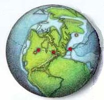 Now consider the 'narrow neck'of land of the Americas of which both the Jaredite and Nephite record speaks.The Jaredites left the Old World in the days of the tower of Babel. Thiswould have been nearer the date of when the lands first begun to be dividedand placed in motion in the days of Peleg. The graphic at the right showsthis placement of the land of what is now southeast United States restingnearly on the top of South America. The chin of Florida is resting on theland's chest. When the neck bends back the Guld of Mexico opens up, the chinpulls away and the distances increase between the lands north and the landssouth just as the eyes become three times the distance from the chest whenthe head is thrown back. This of course is an over simplification. Weassociate today's land shapes and coastal definitions so that our minds cancomprehend the events, but they really where likely quite different and notthe same as we do associate with them. The point here is that the distances back then where not the same distances that we assign to them today. In short Cumorah of New York was not as far distance in the past as it is today. Likely not only the eyes have moved but the chest has so moved also, and they have rotated or turned about the neck. And they shall be 'turned back' in the days of Christ's coming by the word of His power.
Of interest, the graphic just shown is taken from the National Geographic, October 1998, from the opening pages. It was a short article pointing out that a single meteorite encounter or craters aligns along a projected latitude when the land masses are so turned to align along a single latitude as shown. The red circles are the craters, which have been so aligned. This is one of those few items we men have to help us to understand how things fit together back when the lands where or are one land. We don't know what the coastlines where exactly. Thus the assumption that the western coasts shown somewhat resemble those we know today as the western coast of the Americas is a speculation we base on that they are like today to help us understand how things once where with something that is familiar to us. Thus we so speculate. We don't know if the lands broke off piece-mill, we don't know how fast they turned out of their connected state. The last time they did so to us who believe the Bible, says that the earth is much more dynamic is its geography than what science accepts. All in all, we don't know much. We know a few things.
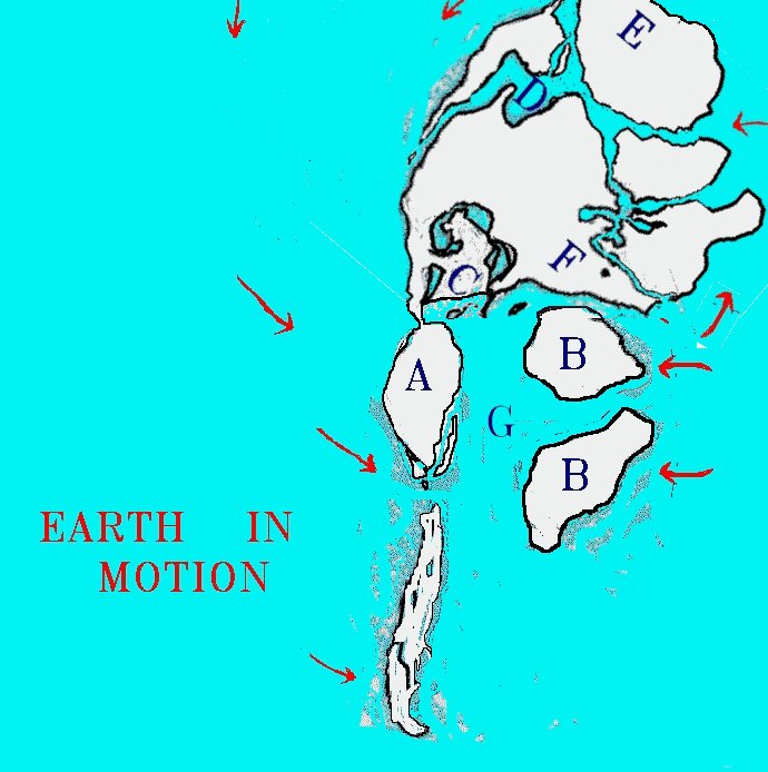 What is not so clear is just what the South America lands where like, the
lands 'south' of the narrow neck in the Book of Mormon before the death of
Christ when the lands where changed and consequentally continued to change
dramatically there after. The Book of Mormon land model, which
my studies prescribe, points out that the eastern coast(s) of South America
('B' in the graphic at the left), which rock formations associate with the
western coast of Africa, does not have to be connected to the lands of the
western Coast of South America ('A' in the graphic at the left) as
they do today. There are evidences of a land separation possibility that
there was an Amazon Ocean/Sea between today's eastern lands of South America
and the western lands of South America. The western coast of South America,
which I associate with the Land South of the narrow neck of land. Now
according to the logistics of the Book of Mormon, the land south, namely
Zarahemla, cannot be as wide to include the vast Amazon regions all the way
to the eastern coast of South America as it is today. This understanding is
further presented and will be addressed in a separate article/chapter. But in
short, the massive land destructions described in the Book of Mormon at the
death of Christ in the old world are indicative of tectonic plate colission
massivenes, not just a few volcanic eruptions. Cities are being swallowed up
by the earth, mountains are raising up out of the plains and valleys, tornados
and huricanes are storming the land in addition to the darking due to the
casting of debris up into the atmosphere. It sounds more like when continents
colide than just volcanism going on.
What is not so clear is just what the South America lands where like, the
lands 'south' of the narrow neck in the Book of Mormon before the death of
Christ when the lands where changed and consequentally continued to change
dramatically there after. The Book of Mormon land model, which
my studies prescribe, points out that the eastern coast(s) of South America
('B' in the graphic at the left), which rock formations associate with the
western coast of Africa, does not have to be connected to the lands of the
western Coast of South America ('A' in the graphic at the left) as
they do today. There are evidences of a land separation possibility that
there was an Amazon Ocean/Sea between today's eastern lands of South America
and the western lands of South America. The western coast of South America,
which I associate with the Land South of the narrow neck of land. Now
according to the logistics of the Book of Mormon, the land south, namely
Zarahemla, cannot be as wide to include the vast Amazon regions all the way
to the eastern coast of South America as it is today. This understanding is
further presented and will be addressed in a separate article/chapter. But in
short, the massive land destructions described in the Book of Mormon at the
death of Christ in the old world are indicative of tectonic plate colission
massivenes, not just a few volcanic eruptions. Cities are being swallowed up
by the earth, mountains are raising up out of the plains and valleys, tornados
and huricanes are storming the land in addition to the darking due to the
casting of debris up into the atmosphere. It sounds more like when continents
colide than just volcanism going on.
There is one point I need some help on. I recall viewing/hearing a progrm on ancient evidence that aligators and/or crocodiles once lived in either the Canadian Alantic Ocean coast regions or the Greenland regions. The details of that are vage to me. I just recall that once those regions of land were in a more tropical climate and if so, it would support the turning back of the eastern North American regions by some type of motion into a more artic zone similar to the motions prescribed by the previous images. Please E-Mail me "hunter@xmission.com" if you have such further information to help refresh my mind to the exact details of this fact.