When the Land Was One
Take 2
prepared by Don R. Hender
"I Believe the Bible to be the word of God as far as it has been
translated correctly. I Also Believe the Book of Mormon to be the word of
God. Further I Believe the Doctrine and Covenants of the Church of Jesus
Christ of Latter-day Saints primarily received by way of the prophet Joseph
Smith to be the word of God. And I do believe that much of what science has
found out and declared to be true with some exceptions relative to a number
of the contrived 'theories' of science which have resulted and have not been
able to yet reach the full matter of the truth for various reasons including
the persuations of the academia of the peer presures of the ivory tower of
human prideful subjectivity. On this basis I will proceed." ~
-drh
Both Science and Religion agree that once, at
least at one time, in the earth's past history the land of the earth was all one
land. The primary discrepency is over when the 'last' previously time that
this land united condition of just one land existed? Science prefers their
thoeries of hundreds of thousands of years ago while the Biblical scriptures,
and the LDS scriptures and doctrine of the Church would point to the more
recent days of Peleg after the flood of Noah and just prior to the days of
the tower of Babel in the Old Testament, which is a relatively short time
compared to the scientific calander, with it being approximately only some
4,000 years ago. The Scriptural accounts mean that the earth can be,
is and will be again much more dynamic than its current status quo reveals
to the scientific mind.
 Science seems to be in general agreement as to how the lands were variously
attached at the time that they were last all one land. Many even propose
that one of the rivers which 'crossed' the land at that time is for much of
its course approximately where the Amazon River is today, runing across the
land identifiable as being that which we know as South America today. Of
course at that very 'early' time, they consider the river ran from the east
to the west, emptying at the western edge of the land into the Oceanic waters
west rather than to the east, into the Pacific rather than into the Atlantic
as we know it today. This one land they have entitled Gondwanaland. One of the most identifiable
connecting points of this one land is that between the lands we identify today
as the West Coastal regions of Africa and the Northern and Eastern Coastal
regions of South America. Of course being such a dynamically removed period
ago the exact shapes then have been 'estimately presumed', even by science,
to be the same shapes of some of the 'continental lands of today, which in
truth cannot truely be atested to.
Science seems to be in general agreement as to how the lands were variously
attached at the time that they were last all one land. Many even propose
that one of the rivers which 'crossed' the land at that time is for much of
its course approximately where the Amazon River is today, runing across the
land identifiable as being that which we know as South America today. Of
course at that very 'early' time, they consider the river ran from the east
to the west, emptying at the western edge of the land into the Oceanic waters
west rather than to the east, into the Pacific rather than into the Atlantic
as we know it today. This one land they have entitled Gondwanaland. One of the most identifiable
connecting points of this one land is that between the lands we identify today
as the West Coastal regions of Africa and the Northern and Eastern Coastal
regions of South America. Of course being such a dynamically removed period
ago the exact shapes then have been 'estimately presumed', even by science,
to be the same shapes of some of the 'continental lands of today, which in
truth cannot truely be atested to.
 The unusual asspect of a scientifically proposed river in Gondwanaland which
parallels the Amazon today but with opposite river flow direction bears a
closer look. The western outlet of the more 'ancient river' would seem to be
approximately located in the regions of what is Lake Titicaca today in
southern Peru and northern Bolivia and there is an the actual existence of a
'natural spilway' preserved in that rigion that though dry today marks a time
when such a waterway did empty into the Pacific. Now presuming that this at
one time marked the extent to which
The unusual asspect of a scientifically proposed river in Gondwanaland which
parallels the Amazon today but with opposite river flow direction bears a
closer look. The western outlet of the more 'ancient river' would seem to be
approximately located in the regions of what is Lake Titicaca today in
southern Peru and northern Bolivia and there is an the actual existence of a
'natural spilway' preserved in that rigion that though dry today marks a time
when such a waterway did empty into the Pacific. Now presuming that this at
one time marked the extent to which 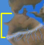 southern Peru once reached before being cut off by a major a 'waterway' or
water division from the land of Bolivia, one can image a much more compact
north to south reach of that land than all the way to the southern tip of
Chili. And this presents an interesting perspective to consider in defining
the early B.C. dated lands of the Book of Mormon from the 'Narrow Neck' of
land to what was termed to be the Sea South, implying the land may have
merely ran from Colombia through Ecuador and Peru. This will be explored
further.
southern Peru once reached before being cut off by a major a 'waterway' or
water division from the land of Bolivia, one can image a much more compact
north to south reach of that land than all the way to the southern tip of
Chili. And this presents an interesting perspective to consider in defining
the early B.C. dated lands of the Book of Mormon from the 'Narrow Neck' of
land to what was termed to be the Sea South, implying the land may have
merely ran from Colombia through Ecuador and Peru. This will be explored
further.
Exactly how the 'lands' looked with their precise coastal appearances is not
known but merely presumed to be as they are today. Most graphic presentations
merely present the one land connected with what is lined out in terms of what
we today would recognize as the continental shapes we are familiar with. There
must be some question as to whether such continents as South America would
have really maintained its current 'today's' recognizable western coastal
shape and image or not. In reallity, most likely not, as much of its western
coast is composed of the great land uplifting events and presures with what
is termed the Pacific or actually Nazca and Antartic plates and the
continously forming Andes which even continues today but at a much reduced
rate of uplift in terms of plate tectonics theories.
Thus presumably, to easily identify such for their audience, science usually
depicts the division of the lands in the currently recognizable continental
shapes without much coastal distortion compared to today's coastlines despite
their claimed hundreds of thousands of years over which their division of the
land is theorized to have occured. To completely presume that such coastlines
were then and now over hundreds of thousands of years would be and is an over
simplification  jump of assumption which is not supportable. And it would seem that their
most favored depection is just how the 'mega' land plates of the continents
of today's South America and Africa did divide apart, pushed by the volcanic
ridge or rift of today's mid-Atlantic Ocean until South America ended up
alone in the southern portion of today's Western Hemisphere. And even that is
a 'great jump' of supposition that South America has allways been one single
recognizable piece of continuous continental land mass.
jump of assumption which is not supportable. And it would seem that their
most favored depection is just how the 'mega' land plates of the continents
of today's South America and Africa did divide apart, pushed by the volcanic
ridge or rift of today's mid-Atlantic Ocean until South America ended up
alone in the southern portion of today's Western Hemisphere. And even that is
a 'great jump' of supposition that South America has allways been one single
recognizable piece of continuous continental land mass.
What 'mega' land plates did or did not brake off between what is South
America and Africa today and their exact coastal shapes and evolution over
the time of the land's division is not ascertainable but only can be
theorized. Science does show that various parts of various lands today
were once at the ocean's floor and visa versa. Thus most all Gondwanaland
separation models are very generalizes theorized guestimations at best.
Though for such general understanding of the concepts involved they are
quite usable to conceptualize how the land was once one and did divide.
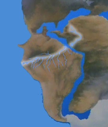
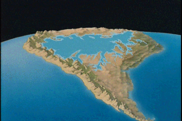
Conceptually, the land plate(s) of South America were once rather level
and in one piece of land, meaning they had not yet been broken up into great
mountain peaks of heights exposing the
 'seams' of the earths crust so often displayed in mountianous regions. [This
may sound familar as there is a similar description given in the Book of
Morman in Samuel the Lamanite's prophecy and according to its fullfilment
(Helaman 14:21-22 & 3 Nephi 8:18) relative to the great earth forming events
caused by the destruction that happen in the land at the time of the death of
Jesus Christ, as the land was once solid and seen in broken up pieces and in
seams everafter the desctruction.] The 'cause' of such geographic land
uplifts is caused by the presures of 'coliding' land plates such as along the
western coast of South America where one such plate is lifted and broken
upward as the other is 'crushed' and sinks below the other. Such 'collisions'
are today for the most part 'gradual' occuring events and great earthquakes
can even mark their occurances today but in less frequency than such a
rapidly occuring uplift would manifest. This uplift which seems to have
caused the great nearly continuous rocky mountain range from Alaska to the
southern tip of South America is locally depicted in the western uplift
motion graphically shown here which raised the great Andean Mountion range of
South America.
'seams' of the earths crust so often displayed in mountianous regions. [This
may sound familar as there is a similar description given in the Book of
Morman in Samuel the Lamanite's prophecy and according to its fullfilment
(Helaman 14:21-22 & 3 Nephi 8:18) relative to the great earth forming events
caused by the destruction that happen in the land at the time of the death of
Jesus Christ, as the land was once solid and seen in broken up pieces and in
seams everafter the desctruction.] The 'cause' of such geographic land
uplifts is caused by the presures of 'coliding' land plates such as along the
western coast of South America where one such plate is lifted and broken
upward as the other is 'crushed' and sinks below the other. Such 'collisions'
are today for the most part 'gradual' occuring events and great earthquakes
can even mark their occurances today but in less frequency than such a
rapidly occuring uplift would manifest. This uplift which seems to have
caused the great nearly continuous rocky mountain range from Alaska to the
southern tip of South America is locally depicted in the western uplift
motion graphically shown here which raised the great Andean Mountion range of
South America.
As just mentioned, according to the Book of Mormon, one such time when the face of
the land, north and south, was changed exposing the 'seams' or layers of the
 crust of the earth where once they were not so readily visible was during the
great catastrophic destruction
crust of the earth where once they were not so readily visible was during the
great catastrophic destruction
 which occured in the land of promise at the time of the death of Jesus
Christ. And what is not usually shown in the 'uplift' motion causing the
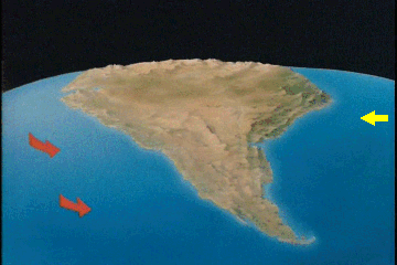
Andean range is the fact that the eastern land plate(s) of South America had
been moving west from the east causing their own contributing forces to
the more complete picture of the plate motions and uplifts going on. The
continuous dividing apart between the African land plate and the South
which occured in the land of promise at the time of the death of Jesus
Christ. And what is not usually shown in the 'uplift' motion causing the
Andean range is the fact that the eastern land plate(s) of South America had
been moving west from the east causing their own contributing forces to
the more complete picture of the plate motions and uplifts going on. The
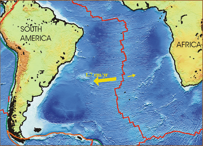
continuous dividing apart between the African land plate and the South
 American land plate(s) was and still is the ever driving force of the
Mid-Atlatic Ridge [at only 2cm/yr today] with its own continuous seam of
ocean floor volcanic
force which seems to run nearly continuously from north to south the full
length of the height of the Atlantic Ocean between the Eastern and Western
Hemispheres.
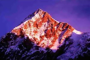
The Book of Mormon even makes a specific mention of a 'great
mountain' being created during the there recorded destrution (3 Nephi 8:10).
I have come to personally consider that the Sierra Nevada de Santa Marta range
and its highest peak of the nation of Colombia named 'Cristobal Colon'
is to be looked to as this 'great mountain'. [Cristobal means 'bearing Christ'
or Chistopher]
American land plate(s) was and still is the ever driving force of the
Mid-Atlatic Ridge [at only 2cm/yr today] with its own continuous seam of
ocean floor volcanic
force which seems to run nearly continuously from north to south the full
length of the height of the Atlantic Ocean between the Eastern and Western
Hemispheres.
The Book of Mormon even makes a specific mention of a 'great
mountain' being created during the there recorded destrution (3 Nephi 8:10).
I have come to personally consider that the Sierra Nevada de Santa Marta range
and its highest peak of the nation of Colombia named 'Cristobal Colon'
is to be looked to as this 'great mountain'. [Cristobal means 'bearing Christ'
or Chistopher]
Then again, there is another matter which science does set forth concerning
the forming of what is today South America as we know it. And that is over
some tens and even hundreds of thousands of years ago as South America was
forming, the once theorized western flowing river of Gondwanaland previously
 alluded to, did swell up when its western outlet was first closed off and
then filled up and expanded and formed into a great Amazon Sea which
paractically filled the entire of the interior of the South American
Continent according to scientists before it dissipated via the now reversed
eastern flowing Amazon River which drains the Amazon Basin today. These
supposes that the Andean uplift did seal the western outlet until the most
ancient river left over from Gondwanaland did backed up into a great inland
sea until the western uplift surpassed the eastern elevations and forced the
great formed 'Amazon Sea' backwards and out its present east coast outlet of
today. On a Bible and Book of Mormon time scale, the enitial 'Andean Uplift)
likely first began some years after Peleg and if the 'inland Sea' was already
present betwix the 'west coast' of today's South America then the vaulting of
the land may have mostly occured at the time of Christ's death and that would
have been when the 'sea south' of the Book of Mormon would have changed and
the Amazon basin uplifted upon the west to begin to fill in from the Adean
silt, closed off western access and the drainage of the 'inland sea' out its
eastern outlet. Interestingly enough there is still what may be considered a
northern outlet if one considers the 'natural canal' which connects the
Rio Negro branch of the Amazon river to the Orinoco river. By that route still
open today, you can boat up one river and out the other from the Atlantic to
the Carribean or visa versa.
alluded to, did swell up when its western outlet was first closed off and
then filled up and expanded and formed into a great Amazon Sea which
paractically filled the entire of the interior of the South American
Continent according to scientists before it dissipated via the now reversed
eastern flowing Amazon River which drains the Amazon Basin today. These
supposes that the Andean uplift did seal the western outlet until the most
ancient river left over from Gondwanaland did backed up into a great inland
sea until the western uplift surpassed the eastern elevations and forced the
great formed 'Amazon Sea' backwards and out its present east coast outlet of
today. On a Bible and Book of Mormon time scale, the enitial 'Andean Uplift)
likely first began some years after Peleg and if the 'inland Sea' was already
present betwix the 'west coast' of today's South America then the vaulting of
the land may have mostly occured at the time of Christ's death and that would
have been when the 'sea south' of the Book of Mormon would have changed and
the Amazon basin uplifted upon the west to begin to fill in from the Adean
silt, closed off western access and the drainage of the 'inland sea' out its
eastern outlet. Interestingly enough there is still what may be considered a
northern outlet if one considers the 'natural canal' which connects the
Rio Negro branch of the Amazon river to the Orinoco river. By that route still
open today, you can boat up one river and out the other from the Atlantic to
the Carribean or visa versa.
Of course these from a pure scientific perspective are generalized theories
spanning thousands upon thousands of years. They span such a lengthy duration
of time and are based upon a few observations and conclusions based
upon a small amoumt of detail. One such fact is that in Argentina up along
the plains and course of the Panaro River there have been found the 'bone'
'not fosil remains' of such things as the teeth and jaws of sharks for a
great distance inland. And there is the courious fact that the Orinoco River
and the Amazon River even today continue to form a dividing waterway which
separates the
 land and which allows the sailing up the one and via such 'connecting' rivers
as the Rio Negro and a natural formed canal and down the other. It is the
only place in the world where two such rivers connect in their 'headwaters'
forming a continuous water course from Ocean to Ocean, or in this case the
Atlantic Ocean to the Carribean Sea without being considered by most as a
division of the continuous South American Continent. Who and what, besides
the brown color silt filled river from the Andean mountains which gives the
Amazon its color as it empties into the Atlantic did determine that that was
the course of the river's mainstream named the Amazon, and not the continuous
course of the River on up the Rio Negro and by the natural canal back to the
Ocean via the Orinoco as the true course of the 'River Sea' of the Amazon, is
not known. Certainly a river's course that never ends must legitamately
be considered as a part of that same river. Without the brown silt of the
Andes coloring the water, who is to say that particular 'stem' of the
river is a tributary and not the main course of the river which runs on
around to the north and back out to sea, forming a continuous loop of
navigitable waterway surrounding the whole of the northeast corner of what is
supposed to be a continent.
land and which allows the sailing up the one and via such 'connecting' rivers
as the Rio Negro and a natural formed canal and down the other. It is the
only place in the world where two such rivers connect in their 'headwaters'
forming a continuous water course from Ocean to Ocean, or in this case the
Atlantic Ocean to the Carribean Sea without being considered by most as a
division of the continuous South American Continent. Who and what, besides
the brown color silt filled river from the Andean mountains which gives the
Amazon its color as it empties into the Atlantic did determine that that was
the course of the river's mainstream named the Amazon, and not the continuous
course of the River on up the Rio Negro and by the natural canal back to the
Ocean via the Orinoco as the true course of the 'River Sea' of the Amazon, is
not known. Certainly a river's course that never ends must legitamately
be considered as a part of that same river. Without the brown silt of the
Andes coloring the water, who is to say that particular 'stem' of the
river is a tributary and not the main course of the river which runs on
around to the north and back out to sea, forming a continuous loop of
navigitable waterway surrounding the whole of the northeast corner of what is
supposed to be a continent.
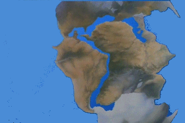
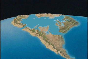 Whether the once Great Amazon Sea was a land locked sea with only a single
outlet such as the Medeterranean Sea, Caspean Sea, and Black Sea; or whether
it was an extention of the Ocean compassed about by various large Islands is
a quandry to consider. The Phoenecians are on record as recording two large
Islands some distance off the coast of Africa. One of which they called
'Iron Island'. That these two eastern Islands mark the land masses and
coastal regions of Eastern South America today is of some question. Certainly
the 'Northeast Sector' framed off by the continuous waterway about the land
would be one such candidate for consideration as one of the islands off the
coast of Africa about 1000 B.C., mid duration since the time of Peleg when
the Bible sets forth that the land was first divided from Africa some added
1,000 years prior according to the Bible account. Then when the major land
island's colisions caused such tremendous destructions as recorded in the
Book of Mormon about 34 A.D. would mark the ending or the beginning of the
ending of the Amazon Sea and it being turned into but the world's most
volumous water course on earth.
Whether the once Great Amazon Sea was a land locked sea with only a single
outlet such as the Medeterranean Sea, Caspean Sea, and Black Sea; or whether
it was an extention of the Ocean compassed about by various large Islands is
a quandry to consider. The Phoenecians are on record as recording two large
Islands some distance off the coast of Africa. One of which they called
'Iron Island'. That these two eastern Islands mark the land masses and
coastal regions of Eastern South America today is of some question. Certainly
the 'Northeast Sector' framed off by the continuous waterway about the land
would be one such candidate for consideration as one of the islands off the
coast of Africa about 1000 B.C., mid duration since the time of Peleg when
the Bible sets forth that the land was first divided from Africa some added
1,000 years prior according to the Bible account. Then when the major land
island's colisions caused such tremendous destructions as recorded in the
Book of Mormon about 34 A.D. would mark the ending or the beginning of the
ending of the Amazon Sea and it being turned into but the world's most
volumous water course on earth.
All in all, there would seem to be at least three Islands surrounding the
ancient Amazon Sea which according to Scripture would have existed and been
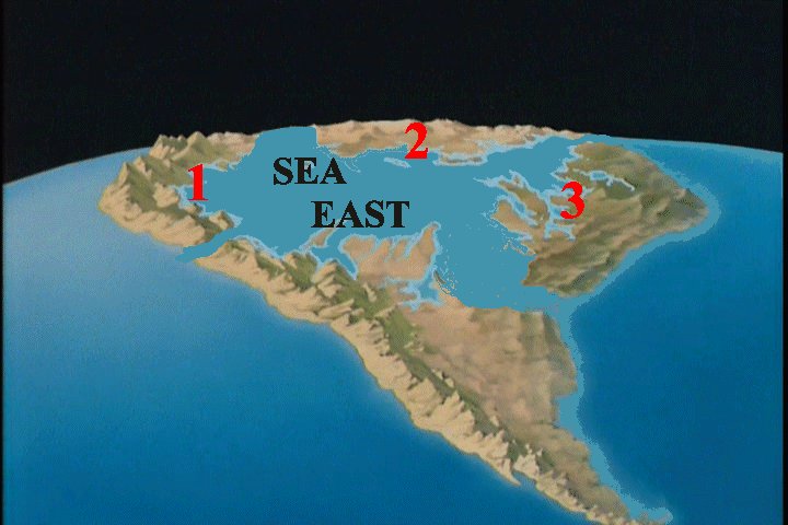 refered to in the Book of Mormon as the Sea East. There would be
(1) Jacob's Island as recorded in the Book of
Mormon and the two Islands (2) & (3) of the
Phoenecians with the Amazon Sea in the midest of them as depicted with a
long string of mountainous regions spaning down along what is Chili today.
Jacob's Island would be bordered upon the south by the ancient outlet 'casway'
about the Titicaca region of the old 'Gondwanaland' unity from the time
of the days of Peleg according to the scriptures. Its east coast would be
bounded by the Great Amazon Sea which Scientists agree existed during the
period of the duration of the dividing of the land until South America takes
on its unified shape it is in today. Reconciling the Scientific time table to
the Scriptural time table of the division of the land, would establish
the Amazon sea to be in existence when the Book of Mormon referenced a Sea
East. Of course the Pacific Ocean would be the Jacob's Island's Sea West and
depending of Lehi's group's ability to have found the narrow passage north
prior to traveling south from their landing sight just south of the Isthmus
of Darien or whether that narrow neck was inundated by the La Nino year which
brought Lehi's party to land at such a location as what could be considered
for Jacob to have come to a conclusion that indeed they where upon an Island
of the sea surrounded by water and in fact most nearly surrounded by water
except for the narrow neck and passage to the land north.
refered to in the Book of Mormon as the Sea East. There would be
(1) Jacob's Island as recorded in the Book of
Mormon and the two Islands (2) & (3) of the
Phoenecians with the Amazon Sea in the midest of them as depicted with a
long string of mountainous regions spaning down along what is Chili today.
Jacob's Island would be bordered upon the south by the ancient outlet 'casway'
about the Titicaca region of the old 'Gondwanaland' unity from the time
of the days of Peleg according to the scriptures. Its east coast would be
bounded by the Great Amazon Sea which Scientists agree existed during the
period of the duration of the dividing of the land until South America takes
on its unified shape it is in today. Reconciling the Scientific time table to
the Scriptural time table of the division of the land, would establish
the Amazon sea to be in existence when the Book of Mormon referenced a Sea
East. Of course the Pacific Ocean would be the Jacob's Island's Sea West and
depending of Lehi's group's ability to have found the narrow passage north
prior to traveling south from their landing sight just south of the Isthmus
of Darien or whether that narrow neck was inundated by the La Nino year which
brought Lehi's party to land at such a location as what could be considered
for Jacob to have come to a conclusion that indeed they where upon an Island
of the sea surrounded by water and in fact most nearly surrounded by water
except for the narrow neck and passage to the land north.
revised October 8, 2013