The Outer Banks of North Carolina
 Historically in the
earliest Colonial days, the 'outer banks' of North Carolina were
generally a long bent line of many sand banks ever shifting in
their size and shapes by the fates of winds, weather and waves.
Today much of those outer 'sand bank' shores have been connected
by maintained lands, roads and highways accessing the popular
outer banks, which maintained a population of over 40,000 people
making them their home and over 7 million people visiting them
annually. Here we'll attempt to construct a type of history of
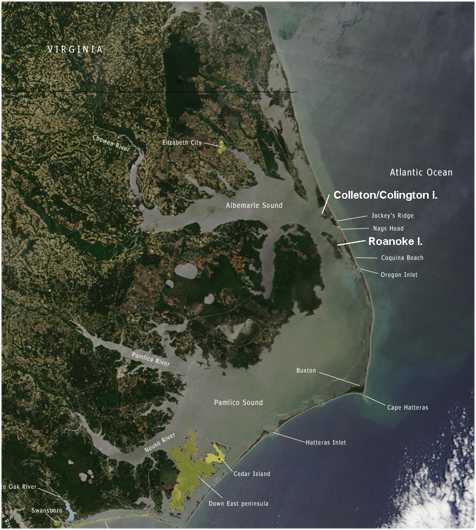
these shores for a greater understanding of them. The simplified
map provided here at the right shows the connecting 'highways'
and some roads with a number of locations marked along the outer
banks today.
Historically in the
earliest Colonial days, the 'outer banks' of North Carolina were
generally a long bent line of many sand banks ever shifting in
their size and shapes by the fates of winds, weather and waves.
Today much of those outer 'sand bank' shores have been connected
by maintained lands, roads and highways accessing the popular
outer banks, which maintained a population of over 40,000 people
making them their home and over 7 million people visiting them
annually. Here we'll attempt to construct a type of history of
these shores for a greater understanding of them. The simplified
map provided here at the right shows the connecting 'highways'
and some roads with a number of locations marked along the outer
banks today.
In the earlier times the sand bars or outer banks were more broken
up providing many more ocean inlets into the mainland coastal land
areas. One such inlet was near Colleton or Luck Island between it
and Roanoke Island which provided a more direct access to the
Albemarle Sound. That inlet is long closed off as are a number
of other once upon a time inlets. In fact early history records
both the closing off of some old inlets and also the opening up of
other new inlets over time as the seas, winds and weather would
shift and cut through and even close up such avenues of ocean
access through the low ocean level sand bars.
Over those earliest of days the little island north of Roanoke
Island was first called Luck/Lucke or Lucker Island. It was
later called Carlyle Island and after it was granted on 8th of
September 1663 to the ownership of Sir John Colleton, it was
renamed from Carlyle to Colleton after Sir John Colleton. The
wording of the conveyance speaks to the 'fluid' sizing of such
Islands as well as the sand bar outer banks. It states that the
island heretofore called Carlyle now Colleton Island was
'contayneing in legkth 5 or 6 miles, in bredth about 2 or 3 myles.
In the more modern times the evolution of the Island's name has
been such as Collington and is today named Colington.
Colleton's agent, Captain John Whittie, established a plantation
on the property during the winter of 1664-1665. He entered at old
Roanoke Inlet, set out beacons to mark the channel, and proceeded
to Colington [Colleton] Island. In his clearing of the land,
Whittie has the distinction of founding the first permanent
English settlement on the 'Outer Banks'. Initially used primarily
for raising cattle and horses, later crops included tobacco, corn,
and grapes and an effort to establish a winery. Whittie found a
secondary source of income by selling oil extracted from whales
washed up on the shore. Peter Carteret, nephew of Lord Proprietor
Sir George Carteret joined Colleton as a partner in the colonial
ventur and arrived in the spring of 1665 to take charge of the
Colleton plantation. Hurricanes, drought, and floods plagued the
plantation settlement, which eventually failed by the 1670s.
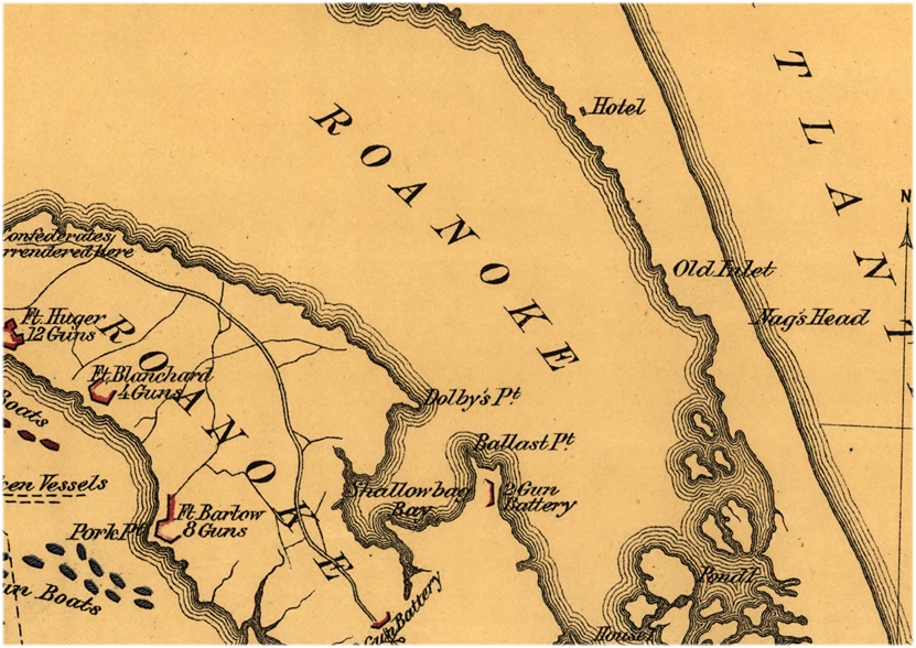
The Battle of Roanoke Island
Today not very many people know that a Civil War Battle was fought
on Roanoke Island. Few of the millions of anual visitors traveling
along Route 64 towards Nags Head or touring downtown Manteo's
shops know that they tread upon a battlefield. Little do they
realize that , around Roanoke Island, a battle was fought between
20,000 soldiers and over 60 ships. As an action in the Civil War,
it was a small engagement but its repercussions far outweighed its
immediate results. For a fuller account connect to The
Battle of Roanoke Island. Now the reason I've referenced this
seemingly remote bit of history is not so much that I am a Civil War
fan, but that when I speak of the 'old Roanoke Inlet' some may raise
their eyebrows and remark that there is still a 'Roanoke Inlet' today
called Oregon Inlet or perhaps some such other inlet or another. But
as the following Civil War related mapping shows of the 1862 Battle of
Roanoke, just above Nag's Head on the map is the 'old inlet', that is
the old Roanoke Inlet shown closed off less than 200 years after
Captain John Whittie sailed in through it to Colleton Island just to
the North. And it is such inlet which at one time gave a more direct
access directly into the Albemarle Sound and was also likely that which
first led the Sir Walter Raleigh colonist into landing at Roanoke
Island, the first though temporary English Colony.
Another little jewel of history also reports the Roanoke Inlet near
Nag's Head. It concerns an action of the American Revolution on 15
August 1776. While 'foraging for food' a British ship patrolling the
many miles of hostile American coastlines along the Atlantic sent a
party ashore of 25 men near the then open Roanoke Inlet to capture
some cattle they had seen grazing along the shore. On shore, American
Captain Dennis Dauge commanded an Outer Banks Independant Company that
patrolled between Currituck and Roanoke on the 'barrier island chain'.
Captain Dauge discovered the British foraging party and attacked them,
killing some and capturing the rest. A website
concerning that event shows a modern map with roads and bridge
access to Roanoke and the Outer Banks attempts to pin-point the location
of that action. The place the action and implied inlet location just
south of Nag's Head though the 1862 Civil War mapping concurrant with
that older date places the 'old inlet' just north of Nag's Head. In
either case the 'old Roanoke Inlet' is thus associated with today's
Nag's Head location.
Today Colleton/Colington Island has virtually been swallowed up
by the development of the sand bars that have been more
permanently connected by the highway along the Outer Banks. The
old Colleton/Roanoke Inlet is closed off and housing tracts and
businesses have filled in the area.
The first real bridge of any kind on to the Outer Banks was
opened to traffic in 1928. It was built by Dare County and
financed by county-backed bonds. The 'primary distinction' at the
time was that the bridge connected the 'sandy ruts at Nags Head'
with the 'muddy ruts on Roanoke Island', because at the time
there were no roads at either end of the bridge. Two years later
in 1930, a group of Elizabeth City businessmen built the first
Currituck Sound Bridge, connecting an oyster shell road at Point
Harbor with a sand trail at Kitty Hawk. Only then did the State
of North Carolina decide to build a road connecting the two toll
bridges. It was known as The Virginia Dare Trail. It was
contructed of asphalt from a plant on the east side of Jockeys
Ridge. The new road opened for potential development fifteen
and a half miles of 'prime oceanfront property' between upper
kitty Hawk and lower Nags Head. And the commercial development
of the Outer Banks was off and running.
The builders of the Currituck Sound bridge, the Wright [Brothers]
Memorial Bridge Company, platted an oceanfront area extending
south from the bridge causeway and began selling lots on what
they called 'Kitty Hawk Beach'. More ventures were attempted having
various levels of success by any number of developers.
|