Nature of the River Sidon
~ An Assessment by Don R. Hender ~
Frequently, in assessing the geography of the Book of
Mormon, the nature, character and the features of the River Sidon come to
play a very large role, as it should. Yet, far too often the river becomes what
the assessor wants it to be in order to match a river that they have chosen
to be the Sidon rather than matching the Sidon to what the Book of Mormon
says the River Sidon should be. Thus it is felt that an honest effort needs
to be undertaken to establish the nature of the River Sidon according to the
Book of Mormon. So I will try.
Its geography, size, capacity or volume, drainage basin characteristics,
etc.
Geographically, the Sidon River ran the entire course of the whole of the
nation of Zarahemla. Zarahemla, in terms of national definition, was during
a particular period in the Book of Mormon, the entire nation of the Nephites. It was
north of the Lamanite nation, which ironically the Nephite record names the
Land or Nation of Nephi. Thus in simplest terms, from the narrow strip of
wilderness which separated the nation of Nephi (Lamanites) and the nation of
Zarahemla (Nephites), north to the narrow neck of land is to be understood
as the Nephite nation (See Alma 22:27-34) from the time Mosiah and his people
had left the land of Nephi (See Omni 1:12-19) to when the Nephite nation
begins to fall. (Now, it must be understood that the name 'Zarahemla' is used
various as the name of the entire Nephite nation, of a more locally situated
provincial land designation round about the city of Zarahemla, and to the
most limited confines of the city of Zarahemla proper. As such, it is a
relationship similar to that of the name 'New York', which can reference
either the limited city of New York proper, the greater city of New York with
its related suburbs, or the entire State of New York, which includes many
counties, cities and lands.)
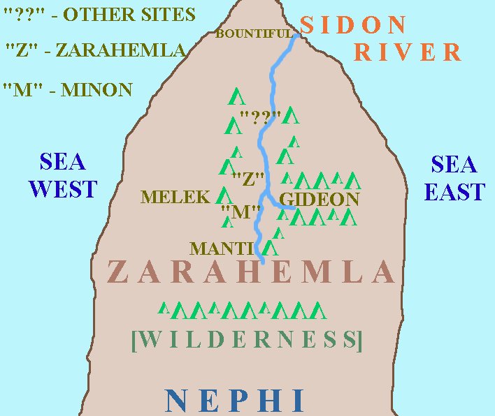 Thus it was that the Sidon River, from its headwaters that were south
above the nation's southern border and of the land regions of the provincial
land of Manti (Alma 43:25, 27, 32, 35, 41 & Alma 44:21-22), ran north through
the land of Minon (Alma 2:24) and on through the central heart of the land,
past the great capital city and provincial land of Zarahemla (Helaman 1:22,
24, 26, Alma 2:15, 27, 34). And thence it continued through other central
and capital lands and cities of the Nephites (Helaman 1:23-24 & 27) until the
river finally reached and emptied into the sea. There is ample evidence in
the Book of Mormon to come to the
understanding that the Sidon River Valley or Basin flowed between two
mountain ranges, one on the west and the other on the east of the river which
did parallel and feed into the river. Simply stated, such accounts of Alma
traveling to the west of Zarahelma, the central Sidon River Valley, went
'over and then into' the provincial land of Melek in his missionary journys
(Alma 8:3) and that west and north of Zarahemla was the wilderness of
Hermounts or wilderness mountains (Alma 2:27). And there is located one noted
'feeding' canyon valley upon the east of the Sidon Valley and River, which
housed the provincial land and presumably city of Gideon, in the eastern
valley of Gideon (Alma 2:20, Alma 6:7). And there is likely at least one other
'valley entrance' from the east in the upper regions of the Sidon Valley
about Manti, which the Zormaites used when they traveled round and about to
Manti traveling south and west at the same time that Captain Moroni used
the shorter eastern route into the Sidon valley using the Valley of Gideon
access (See Alma 43).
Thus it was that the Sidon River, from its headwaters that were south
above the nation's southern border and of the land regions of the provincial
land of Manti (Alma 43:25, 27, 32, 35, 41 & Alma 44:21-22), ran north through
the land of Minon (Alma 2:24) and on through the central heart of the land,
past the great capital city and provincial land of Zarahemla (Helaman 1:22,
24, 26, Alma 2:15, 27, 34). And thence it continued through other central
and capital lands and cities of the Nephites (Helaman 1:23-24 & 27) until the
river finally reached and emptied into the sea. There is ample evidence in
the Book of Mormon to come to the
understanding that the Sidon River Valley or Basin flowed between two
mountain ranges, one on the west and the other on the east of the river which
did parallel and feed into the river. Simply stated, such accounts of Alma
traveling to the west of Zarahelma, the central Sidon River Valley, went
'over and then into' the provincial land of Melek in his missionary journys
(Alma 8:3) and that west and north of Zarahemla was the wilderness of
Hermounts or wilderness mountains (Alma 2:27). And there is located one noted
'feeding' canyon valley upon the east of the Sidon Valley and River, which
housed the provincial land and presumably city of Gideon, in the eastern
valley of Gideon (Alma 2:20, Alma 6:7). And there is likely at least one other
'valley entrance' from the east in the upper regions of the Sidon Valley
about Manti, which the Zormaites used when they traveled round and about to
Manti traveling south and west at the same time that Captain Moroni used
the shorter eastern route into the Sidon valley using the Valley of Gideon
access (See Alma 43).
[Note: For the simple reason that the wilderness of Hermounts was both north
and west of the province and city of Zarahemla, which wilderness would have
continued north into the lower regions of Bountiful; it is presumed that
the lower northern course of the River Sidon empties into the sea east of the
narrow neck and Bountiful rather than the sea west of the narrow neck and
Bountiful.]
Thus, so much for the simple general geography of the River Sidon. Now,
without any further presumptions, other than what the Book of Mormon does
record which yields this simple mapping; it ought to be pointed out that
the River Sidon's general geography parallels that of the Magadalena River
of Columbia, South American. This is pointed out simply because of such
records of a number of the early church authorities and scholars so reporting
that the Magdalena River and the Sidon River were one and the same. Thus we
can see how the Book of Mormon record would seem to support their report
without such contrivances which actually contradict the Book of Mormon text.
The Sidon River's size and magnitude.
The Sidon river was no small river. It was feed by two parallel mountain
ranges upon its east and west and also from the southern mountainous
highlands which separated the lands of Nephi and Zarahemla. (That the regions
between the land of Zarahemla and the land of Nephi was a mountainous highland
becomes apparent since when ever one travels in the Book of Mormon from
Zarahemla to the land of Nephi, it is always reported that they are going 'up'
to the land of Nephi. And visa versa, whenever one travels from the regions
of Nephi to Zarahemla, they are going down to Zarahemla, and this in spite of
the temple (the mountain of the Lord) being located at Zarahamla. Further
Manti was in the 'Valley of Sidon' and was above Zarahemla, for the river
ran 'down' north to the capital city of Zarahemla from Manti. All this, with
'many' lands and cities all along the course of the Sidon River from the South
down to the North even until the river reached the sea, so implies a long
river valley which forms a great river drainage basin which feeds the river
Sidon.
Further, the Sidon River was a large sizable river even in its most upper
regions of Manti and with the additional flows into it is must be considered
to be a great and powerful river which moved with great force. Imagine
casting countless thousands of dead bodies into a river at its upper
'headwater' regions as did Captain Moroni (See Alma 44) and having the river
be large enough and strong enough to carry those bodies out to sea what must
have been hundreds of miles away without encumbering the land below the upper
river. If you were to cast thousands of bodies in the any river in Northern
Utah, such as the Jordan river which runs north from Utah Lake to the Great
Salt Lake, they would be strewn, built up and clogging the river all along
its course with little success in having those thousands of bodies ever to
reach and disappear in the Great Salt Lake. Thus, whether from its source
in the south to even its mid stream about Zarahamela, where Alma also
deposited countless Lamanites bodies destined to the sea (See Alma 2); the
flow of the river Sidon was grand and strong enough to carry all such bodies
out to the Ocean according to the Book of Mormon record. This represents a
grand wide strong river such as the Mississippi, not just some mountain
stream, or a river consisting of 'narrows' to clog and byways into which to
deposit debris. This also matches the Magdalena River which can be navigated
by ships all the way into the interior of Columbia to its capital Bogota,
located in an 'eastern' valley off of the main Magdalena Valley, just as was
Gideon.
A Laundry List Summary of Characteristics of the Sidon River:
- It runs north and south in its upper valley from Manti to Zarahemla at least.
- Only about half of its distance is above Zarahemla, to the south of Zarahemla
since Zarahemla is in the center of the land and Sidon starts at the Southern
reaches of the land southward, high up by Manti. Thus approximately half of
the river must lie beneath Zarahemla to the sea into which Sidon empties
countless dead bodies during the Nephite times (It must be considered that the
deposit of Magdalena has widened and spread this outlet out over the years to
a large deposit field to the ocean today, especially since the debris of all
the destructive force at the death of Christ must have also had to run down
its course.).
- The lower half of the river begins from Zarahemla in a northerly direction,
but due to the description of the wilderness area of 'Hermounts' it might be
accessed that Sidon which continues to flow down to the ocean must take a
turn to the northeast to an extent to miss flowing right through the middle
of the wilderness of Hermounts which is to the North and West of Zarahemla and
which butts into the wilderness of Bountiful. Thus a Northeast flow at least
is assumed as the river adjusts to miss Hermounts, Bountiful and the Narrow
Neck. Further, Hermounts would be a heavily forested area most likely sloping
up to 'her-mounts' or mountians. Rivers run down out of or away from up
slopes that are heavily forested rather than up into the forest on the
hillsides of 'her-mounts.'
- There are two plains mentioned in the lands of Zarahemla. They are the plains
of Nephihah, which is/was a great prominent plain to the east of Zarahemla
sloping down to the sea from the east mountains of the Sidon Valley which had
one named open valley to the east in the Valley of Gideon. The other plains
mentioned are the plains around Bountiful and south to Morianton, North of
Zarahemla and east of Bountiful toward Morianton upon which the Lamanites are
defeated. Between these two plains, which slope to the sea, the Eastern
plains of Nephihah are not a good candidate for the river Sidon to make an
abrupt turn and flow back south to exit to the sea on the plains of Nephihah,
which are actually accessed by the Valley of Gideon to the South of Zarahemla.
Rather the better candidate for the river Sidon to exit to the sea, is from
the plains near Morianton which are north and east or Northeast or even
North by Northeast of Zarahemla depending on the degree that Sidon does turn
to the east to avoid Hermounts. This is more viable also because a strong
river, such as Sidon is portrayed to be, would be more difficult to turn
abruptly to begin to meander directly east and even southeast to exit onto
the Nephihah plains east and southeast of Zarahemla.
- It is most likely that the lower river Sidon, as it approaches the ocean, is
joined by another river from the west. This would be the river that flows
down the parallel valley to the Sidon valley in which the Land of Melek and
all of its surrounding cities, towns, and villages are a part of and of which
Ammonihah and Noah and all of its cities, towns and villages are a part of.
Alma traveled across the upper mountains to the west to go 'over into' the
parallel valley of Melek and traveled three days 'due north' from there down
that valley to Ammonihah. This parallel river would also likely turn eastward
due to the Wilderness of Hermounts which was North and West of there as well,
for Bountiful and the narrow neck was to its north. Thus we look for two rivers to join on the plains of Morianton before they
enter the sea together.
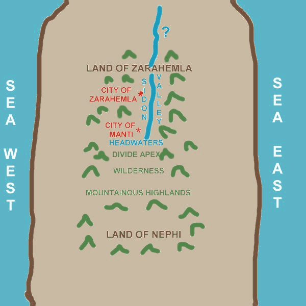
The River Sidon was a great river. Zarahemla was about half way down the
river from the river's headwaters which began up above and beyond Manti.
Zarahemla was in the center of the land. While the River Sidon had to be
large enough and powerful enough to carry thousands of bodies down the river
to the sea. It also had to be a navigable river. This is power and size.
It is of further interest that the Mulekites located and built their chief
civilization in the middle of the land, away from the sea, though they
arrived then by way of the Ocean. How did they get to their city site? A
possible way is for them to have sailed up a navigable river to the center
of the land. Lots of rain and lots of drainage out of surrounding mountains
had to feed this large river and that must have been a in a large drainage
basin or valley which could support large populations of people. Wide and
powerful but navigable, at least as far as mid-way up the river into the
heart of the land makes sense. Sounds like the Magdalena River to me as so
reported by various church authorities and scholars.
How does the Magdalena river fit the Book of Mormon record of Sidon?
The Magdalena River is a navigable river up as far as the branching off in
the regions of Bogota. That is in the center of the land of Colombia.
Its upper regions are North-South running as was the upper Sidon river from
Zarahemla to Minon to Manti in the course to the land of Nephi south. And it
is a large drainage valley with the cordillera of the upper Andean core and
the central and eastern mountain branches cradling the valley and the river
as it runs to the sea.
One might ask, what about crossing such a mighty river, such as when Alma
crossed the river to fight the Lamanites (See Alma 2). The Lamanites wanted
to fight and destroy the Nephites, thus they came to fight, they were ready
to fight, they wanted to fight. So rather than preventing the Nephites from
crossing the river Sidon from the east, they wanted them to cross and they
were ready for them at that point on the west bank where their crossing
exited, to fight them and destroy them.
How often we envision the Nephites 'wading waist deep' and even swimming in
the River Sidon crossing this river in the water cumbered by their armor and
weapons, through the water and climbing up on shore dripping wet? Well maybe
that might be. But consider that the nature of the River Sidon was a mighty
enough river to carry men's bodies from the inner central regions and even
upper regions of the land, all the way out to the sea or the ocean. That
does not sound like a river to wade across or even swim across. The Nephites
were an intelligent and industrious people. Why did Alma have to travel to a
particular point to cross? How did the Lamanites know where to form their
forces to receive the Nephites upon crossing? Just what was the means of
crossing the River Sidon? If it was not by wading and swimming it what was it?
Could it be that the Nephites had bridged the river at a particular junction?
Why didn't the Lamanites block or destroy the bridge? They came to fight not
to avoid a fight. They were ready to fight and did not want to avoid a fight.
They wanted to fight and were willing to let the Nephites cross over the
bridge to where they were, ready and waiting to meet them on the western
banks of the river. Just maybe. And if not a 'bridge', certainly forms of
water craft would have been made available for crossing at such a junction of
the major capital city of the land. And if not 'ferries' then one must
consider how in mass did Alma move his army from Zarahamela to the east shore
to begin with. Certainly such 'in mass' crafts would set ready to take Alma's
army back across. It does not make sense for an army to 'wade or swim' across
such a mighty river. What makes sense is for a great city as Zarahemla and
such large numbers as an army to have other ready resources for such crossing
of rivers. Perhaps this was the mode which Captian Moroni left the
Zoramite lead Lamanities to experience in the highlands about Manti, but
the logic of it fails about Zarahemla and the mid-course of the Sidon River.
Sources of Reports that Sidon is Magdalena:
(Dictionary of the Book of Mormon, p. 326)
Dictionary of the Book of Mormon, by George Reynolds, p. 326
SIDON, RIVER
The most important river in Nephite history; known today as the
Magdalena. It runs northward through the United States of Colombia and
empties into the Caribbean Sea. In the days of the Nephites it formed an
important factor in their civilization, as many of their largest cities were
built on its banks, and its valleys were the most densely populated of any
part of the country. Near its head waters was Manti, the chief city of
the south, and further north were Gideon and Zarahemla. It was
also the grand trunk road to the land of Nephi, and along its banks poured
the hosts of the dark-skinned Lamanites when they forced their way into the
land of Zarahemla. Among the most important events that occurred in its
immediate neighborhood were:
Related Nephite History Dates:
The Amlicites defeated at the hill Amnihu, B. C. 87.
Two invading armies of the Lamanites defeated, one on its west bank, the other on the east, B. C. 87.
The Lamanites defeated at the hill Riplah, B. C. 74.
Manti captured by the Lamanites, (about) B. C. 68.
Manti reoccupied by the Nephites, B. C. 63.
The Lamanites invade Zarahemla, capture the capital and advance northward, but are finally driven back, B. C. 51.
The Lamanites again invade Zarahemla, B. C. 35.
The Lamanites obtain possession of the whole of South America, B. C. 33.
The Lamanites, being converted, restore to the Nephites Zarahemla and the lands they had wrested from them, B. C. 30.
The Nephites, under Lachoneus, all gather to the lands of Zarahemla and Bountiful, A. D. 17.
The Nephites return to their homes on both continents, A. D. 26.
Zarahemla and other cities destroyed during the great storms and
earthquakes that attended the crucifixion of the Redeemer, A. D. 34.
Relationship of the Land of Nephi to the Land of Zarahemla.
Mosiah was warned of God to depart out of the Land of Nephi. The Book of
Omni tells of Mosiah's travels from the Land of Nephi to the land of Zarahemla.
13 And it came to pass that he did according as the Lord had commanded him.
And they departed out of the land (of Nephi) into the wilderness, as many as would hearken unto the voice of the Lord; and they were led by many preachings and prophesyings. And they were admonished continually by the word of God; and they were led by the power of his arm, through the wilderness, until they came down into the land which is called the land of Zarahemla.
 Now, from the Book
of Mormon, the Land of Nephi is portrayed as being a land in a higher
elevation than the land of Zarahemla as the people of Mosiah 'came down' from the Land of Nephi to enter 'into' the land of Zarahemla. Further, from the Book of Mormon we are given to know that Zarahemla was in a river valley on the west bank of the River Sidon. Thus it seems a logical conclusion that the Land of Nephi was in the highlands or 'mountains' if you will and Zarahemla was in a lower land or valley along the River Sidon. Now the River Sidon did not originate in the Land of Nephi as its head waters was still in the land of Zarahemla just above the land of Manti. Therefore there must have been a 'mountainous' divide where the water on the one side flowed from and were the head waters of the River Sidon. And on the other side, beyond the wilderness to the south, beyond the apex of this divide laid the Land of Nephi, which itself was still higher in the mountains highlands than was Zarahemla.
Now, from the Book
of Mormon, the Land of Nephi is portrayed as being a land in a higher
elevation than the land of Zarahemla as the people of Mosiah 'came down' from the Land of Nephi to enter 'into' the land of Zarahemla. Further, from the Book of Mormon we are given to know that Zarahemla was in a river valley on the west bank of the River Sidon. Thus it seems a logical conclusion that the Land of Nephi was in the highlands or 'mountains' if you will and Zarahemla was in a lower land or valley along the River Sidon. Now the River Sidon did not originate in the Land of Nephi as its head waters was still in the land of Zarahemla just above the land of Manti. Therefore there must have been a 'mountainous' divide where the water on the one side flowed from and were the head waters of the River Sidon. And on the other side, beyond the wilderness to the south, beyond the apex of this divide laid the Land of Nephi, which itself was still higher in the mountains highlands than was Zarahemla.
Wandering Thoughts:
Now let me jump to some parallel conditions of the lands I would look to
be the primary lands of the Book of Mormon. Chavin was built in the
mountains, away from any major water way to the sea. It was a place that
just seemed to appear out of no where about 600 BC in the Mountain regions of
northern Peru. A temple which is like unto the temple of Solomon was built
at Chavin. Nephi built a temple like unto the temple of Solomon in his land
of Nephi after departing from his brethren Laman and Lemuel, having traveled
many days to reach this highland, mountainous region of the Land of Nephi.
Chavin matches just such a place. If you were to travel from the land of
Chavin in Peru to the valley of the Magdalena River in Colombia about half
way down the river, you would have 'come down into' the land of Central Colombia into its central major valley from Northern highlands of Peru.
Further, Zarahemla is said to be in the center of the land of Zarahemla.
Thus if the River Sidon begins at the northern extremity of the Land of Zarahela, then the City of Zarahela must be about half way or midway down the River Sidon. And from there, regardless of where the river flow, it is another half of the river to make it to the sea, into which Sidon empties. Since the mountainous valley of the upper Sidon is implied to run north to south, the it is assumed that the lower half of the river also might flow in a similar direction.
[Final Note: An Objective Assessment? What makes an assessment
objective? It is not whether one does or does not associate a site or land
with the Book of Mormon geography. It is if one forces the issue and presents
such subject self contrived considerations and thoughts. The consideration
that the River Magdalena is the River Sidon is not a personal subjective off
the cuff consideration. It is not my own consideration, but that of such who
are authorities of the church. Thus such application of assessment IS
NOT a self-serving subjective attempt. Further, no subject interpretive
spin, slant or contrivance as to what the Book of Mormon does or does not
state is given of my self. This is a straight forward reading and
understanding of the words of the Book themselves. The Book states it. I have
merely restated what the Book of Mormon has stated. I've not brought in any
outside explanations such as altering of compass directions other than
merely stating what the Book of Mormon states as translated by Joseph Smith.
North is north, south is south, east is east, and west is west, when
mention of other cities and lands are made by the Book of Mormon, only what
is stated is given. There is no such attempt to so limit what the Book of
Mormon has stated and to alter what it states into something, which needs
subjective interpolation in order for an application to be made to any
personally contrived considerations. This is just about as objective as one can
get and still have some relationship to the world as it is. Objectivity must
have a basis in reality. To ignore the parallels between Sidon and Magdalena
would to be to cut one's self off from the reality of the matter that many
authoritative reports have so stated it to be the case.
Revised: August 2006