The Narrow Neck of Land
by Don R. Hender
The matter concerning the narrow neck of land
of the Book of Mormon has been a topic of much discussion. There is actually only two places in
the Book of Mormon where the phrase 'narrow neck' even appears and only one place where the
complete phrase 'narrow neck of land' is used. The first graphically chronological place is
where Moroni, the last Book of Mormon prophet, uses the complete term in his abridgment of
the Jaredite record and there in relationship to a city of the Jaredites that wad 'by' the
narrow neck of land (Ether 10:20). The other place is where it speaks of Hagoth and where he
launched forth his ship in to west sea, which was by the narrow neck (Alma 63:5).
"And they built a great city by the narrow neck of
land, by the place where the sea divides the
land." ~ Book of Mormon | Ether 10:20
"And it came to pass that Hagoth, he being an exceedingly curious man, therefore he went forth
and built him an exceedingly large ship, on
the borders of the land Bountiful, by the land
Desolation, and launched it forth into the west sea, by the
narrow neck which led into the
land northward." ~ Book of Mormon | Alma 63:5
It is in the contextual reading concerning tha great city of commerce of the Jaredites that one
is able to deduce and understand that the narrow neck of land where the city was built, was
that which lead into the land southward, which by the Jaredites used as a natural preserve for
resources. That is they did not build cities or lands of habitation in it, but they did use it
for hunting and the gathering of nature's resources. You could say it was their national forest
lands. Then it is that verse regarding Hagoth were we are introduced to the fact that this
narrow neck, where the border land Bountiful and land Desolation was located on the west sea,
is where Hagoth launched his exceedingly large ship. And for further understanding we can next
turn to that 'universal' Book of Mormon land description provided by Mormon as a perior peice
of about 90 B.C. concerning the lands of Zarahemla and Nephi.
"And it came to pass that the king sent a proclamation throughout all the land, amongst all his
people who were in all his land, who were in all the regions round about, which was bordering
even to the sea, on the east and on the west, and which was divided from the land of Zarahemla
by a narrow strip of wilderness, which ran from the sea east even to the sea west, and round
about on the borders of the seashore, and the borders of the wilderness which was on the north
by the land of Zarahemla, through the borders of Manti, by the head of the river Sidon, running
from the east towards the west—and thus were the Lamanites and the Nephites divided.
"Now, the more idle part of the Lamanites lived in the wilderness, and dwelt in tents; and
they were spread through the wilderness on the west, in the land of Nephi; yea, and also on the
west of the land of Zarahemla, in the borders by the seashore, and on the west in the land of
Nephi, in the place of their fathers' first inheritance, and thus bordering along by the
seashore.
"And also there were many Lamanites on the east by the seashore, whither the Nephites had
driven them. And thus the Nephites were nearly surrounded by the Lamanites; nevertheless the
Nephites had taken possession of all the northern parts of the land bordering on the
wilderness, at the head of the river Sidon, from the east to the west, round about on the
wilderness side; on the north, even until they came to the land which they called Bountiful.
"And it [Bountiful] bordered upon the land which
they called Desolation, it [Bountiful]
being so far northward that it came into the land which had been peopled and been destroyed,
of whose bones we have spoken, which was discovered by the people of Zarahemla,
it [where Bountiful border Desolation] being the place of their [people of Zarahemla] first
landing.
"And they [people of Zarahemla] came from there up into the south wilderness. Thus the land
on the northward was called Desolation, and the land on the southward was called Bountiful, it
being the wilderness which is filled with all manner of wild animals of every kind, a part of
which had come from the land northward for food.
"And now, it was only the distance of a day and a
half's journey for a Nephite, on
the line Bountiful and the land Desolation,
from the east to the west sea; and thus the land of Nephi
and the land of Zarahemla were nearly surrounded by water, there being a
small neck of land between the land northward
and the land southward.
"And it came to pass that the Nephites had inhabited the land Bountiful, even from the east
unto the west sea, and thus the Nephites in their wisdom, with their guards and their armies,
had hemmed in the Lamanites on the south, that thereby they should have no more possession on
the north, that they might not overrun the land northward.
"Therefore the Lamanites could have no more possessions only in the land of Nephi, and the
wilderness round about. Now this was wisdom in the Nephites—as the Lamanites were an enemy to
them, they would not suffer their afflictions on every hand, and also that they might have a
country whither they might flee, according to their desires."
~ Book of Mormon | Alma 22:27 - 34
Now there are many interesting things that can be determined concerning the lands of the Book
of Mormon from this lengthy account of the lands of Zarahemla and Nephi at the time that the
Lamanite King made his proclamation concerning the treatment of the missionary sons Mosiah in
the land of the Lamanites. Though as noted the term 'narrow neck' only appears twice, here
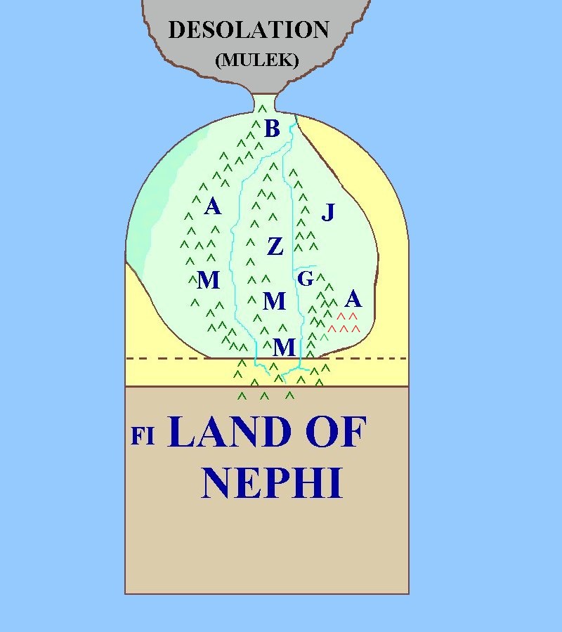
in Alma 22 a synonym of 'narrow' is used where it speaks of a 'small neck of land.' Also an
accompanying rough mapping is provided to aid one in their reflective reading of the land
descriptions of Alma 22. (For a further review of the land and the map see
'BoM Geo. 101.)
What is important to our discussion here is that between the land northward where the Jaredites
did one time live and the lands southward of Zarahemla and Nephi, there is a narrow or small
neck of land. Such a narrow neck between two large sized lands is call an 'Istnmus.' And one
other item which will prove of interest to note is that from 'east to west' on the border
'line' between Bountiful and Desolation it would only take a Nephite a day and a half journey
to cross from sea to sea.
Now most all readers, students and scholars of the Book of Mormon do come to such obvious
conclusions as presented here. And the various discussions will most often settle upon such
matters. There are other such matters discussed and we will cover another such, but after what
is here presented next. Now that distance of a 'day and a half journey' becomes a hot topic
of discussion, with any number of various personal stipulations and subjective determinations
placed upon it. One states that it is a standard distance measure of how far a Nephi can walk
in a day and a half even though it being put in a 'half' measure makes it a bit difficult to
work with as a meausuring unit. Another state that anything over 45 miles covered is not
to be considered realistic for more that 30 miles per day is 'ridiculous'. Other will argue,
will that depends on a mode of transportaion or that a Zulu Warior, which we are to presume
a Nephite warior is equal to, can 'military march' 50 miles in a day and fight a battle at
the end of that march, so 75 mile distance is possible. As to mode of transportation another
could point out that Lewis and Clark would travel 75 miles plus in a day's time by canoeing
down river on their return journey. All such is good for discussion and personal opinion. But
what is really possible in terms of a location and the reality of such a narrow isthmus crossing
from sea to sea. To that question of actual fact, I will present the following.
Many have scoffed at me when I have held to the Isthmus of Darien as being the narrow neck of
land, which the statement attributed to Joseph Smith does suggest concerning Lehi's landing
site (TPJS p. 267). They say the distance is too far, the rainforest jungle is too thick and
so forth. And they will summarily write it off per their own 'conclusive discussions' with
those who are of the same mind as they are. But there is one 'objective' historical witness
as to the truth of what is concerning the Isthmus of Darien. It was published in 1697, though
I doubt that Joseph Smith ever saw it. I've had to wait until my older years than Joseph lived
to find it and only by the access of the information super highway did I find it on the World
Wide Web. I present it for consideration next below:

The As Entrance into the South Sea
[Map from book 'A New Voyage Round the World,' by William Dampier, London,
1697]
A Quote From William Dampier
" ...
Our first landing place on the south coast was very disadvantageous, for we travelled at least
fifty miles more than we need to have done, could we have gone up
Cheapo River, or Santa Maria River; for at
either of these places a man may pass from sea to sea in three days time with ease. The Indians
can do it in a day and a half, by which you may
see how easy it is for a party of men to travel over. ..." ~ William Dampier,
A New Voyage Round the World, Chapter 2
Marked upon this map, which I have highlighted in yellow, is 'The As Entrance into
the South Sea' if you are able to read upside down. An obvious deduction is the the 'A' stands
for Atlantic as 'The Atlantic's Entrance into the South Sea.' What it shows is the foot path
marked with hash marks, which leads from the east to the head waters of the then terms River of
St. Maria. Then part way down those head waters the 'foot path' ends and the natural presumption
is that, which doesn't take a rocket scientist to deduce, then one would take to the river route
and float the river on down to one's destination rather than to walk the rest of the way.
William Dampier reports in his text that it was about a 3 day journey for his privateers and
but only a day and a half's crossing for a native indian. William nor I would likely to be
able to tell you if that Indian were a Nephite or not, but certianly it is possible by the
native Americans to cross the Darien 'from east to west' in a day and a half's time. That was
just 'common ability' for that native Indian or dare I say Lamanite or Nephite of William
Dampier's day.
As stated in Dampier's quote, there are two places of possible crossing which are 'easy'
according to Dampier. Note where the 'Cheapo River and the Santa Maria Rivers' are on
the map. Now consider the two reports of the Book of Mormon of two such sites. The one
already noted in Alma 22:32 above is said to be done in a 'day and a half' as parallel's
Dampier's report the other is here quoted below in relationship to the narrow neck crossing
at another site.
"And there they did fortify against the Lamanites, from the west sea, even unto
the east; it being a day's journey for a Nephite, on the line which they had fortified and
stationed their armies to defend their north country."
~ Book of Mormon | Helaman 4:7
 Now the changes at the time of Christ could account for the differences of a half a day's
travel, but it would seem that along their 'developed' line of defense, from the west sea
even unto the East, their travel distance was but one day for the ability of a Nephite.
One possiblility I have heard is that the line did not go all the way to the east sea as
it is not specifically mentioned, perhaps due to intervening rugged terrain and perhaps
even a defensive city already upon the east coast like the city Bountiful was located. Any
one of those circumstance might contribute to the difference in time/distance. As to
candidates for such two locations one might consider the lower neck location of the
Santa Maria river location and the upper neck location of the Cheapo river location as
so proposed by the accompanying rough illustrated map.
Now the changes at the time of Christ could account for the differences of a half a day's
travel, but it would seem that along their 'developed' line of defense, from the west sea
even unto the East, their travel distance was but one day for the ability of a Nephite.
One possiblility I have heard is that the line did not go all the way to the east sea as
it is not specifically mentioned, perhaps due to intervening rugged terrain and perhaps
even a defensive city already upon the east coast like the city Bountiful was located. Any
one of those circumstance might contribute to the difference in time/distance. As to
candidates for such two locations one might consider the lower neck location of the
Santa Maria river location and the upper neck location of the Cheapo river location as
so proposed by the accompanying rough illustrated map.
|