Zarahemla and Colombia
(Topology of the Greater Land of Zarahemla and of the Nation of Colombia, South America)
The land of Zarahemla, like all real lands, has a past and a history that
goes into understanding the topology, geography, and setting of the land. As
all land was washed new with the flood of Noah, not much can be said relative
to extending the past of a land to a pre-flood era other than that Central
North America has been associated with being the original land of Adam where
first all promises of God to man where made and where all will be culminated
in the end. From the site of his altar of worship before the Lord, to his
administrations to his posterity both then and in the near future of now (See Adam-ondi-Ahman). People could have lived all over
the land, but the flood and the dividing of the land in the days of Peleg
would have left little if any civilization effects upon the topology of the
lands of the Americas pre-flood.
As for the land of Colombia and Zarahemla, even post-flood, the
civilization effects upon the land's topology would be minimal, as the
Jaredites associated with the Olmec, left the land south as a primitive and
natural land. Even Lehi’s colony traveled through the land on their way to the
lands further south upon their arrival in the land of
Bountiful. Thus it was not until the people of Mulek (about 580BC) begin
to inhabit the land, is there a contributing society of permanent civilization
that begins to add to the topology of the land. Mulek's people located in
the center of the land in the broad Sidon (Magdalena) River valley. They may
have even sailed from their original landing where they found Coriantumr and
traveled up the navigatible Sidon to where they began their society on the
west backs of the river, having fled to the ends of the earth away from the
Kingdom of Nebuchadnezzar's Babylon. Even then, there is no written history of
the people of Mulek until the days of their King Zarahemla when they are
joined by the people of Mosiah and become the Nephites of the land of
Zarahemla. Thus only in the time frame of the Nephite occupation of the land
of Zarahemla of about 500 years from about 150 BC (see book of Omni) to 350
AD (Mormon 2:28-29) do we have a written history of the land of Zarahemla and
what it was like. Most all of this historical record that contributes to the
known topology of the Land of Zarahemla occurs from 130 BC (Book of Mosiah)
to the coming of Christ (34 AD - 3 Nephi). Thus most
of the written evidences of the land occur prior to the great destruction
that occurred at the death of the Savior. So great was the destruction that
major changes in the land occurred. But enough remains that generalized
comparisons can be made which strikingly fit the land of Zarahemla with the
land of Colombia.
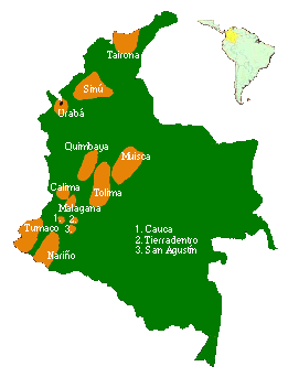 To the right is a map showing a number of Colombia's
'Pre-Colombian civilization locations. Note they follow the two river valleys
of the Magadalena River and the Cauca River in the Central lands of Colombia.
Then at the head of the Magalena River is another noted civilization and
from thence west along the western sea coast is another. There is one noted
on the high plateau of today's Bogata area the then along the northern coasts
and the narrow Darien neck. Though often dated later than the days of
Zarahemla before Christ, the pattern is somewhat striking in relation to
the described lands in the Book of Mormon. For example some quick and loose
associations
to the sites might be Tierradentro - Judea, San Agustin - Manti, Turnaco -
City by the Sea, Malgana and Calima - Melek and surrounding lands, Quimbaya -
Ammonihah and Noah, Tolima - Zarahemla and surrounding cities such as Minon,
Maisca - Gideon,
Jershon or Aaron, Uraba - Bountiful. This may not be the case but there are
correlations with the Magdalena River being Sidon. Later societies tend to
build upon past successful sites and in this the pattern begins to fit.
And that should be the extend of it. It is a pattern of fit. Obviously
the societies of 400 AD on are not the societies of the pre-Christ or even
the first 200 to 300 years after Christ societies. They are the 'pagan'
societies of the apostate descendants of Lehi and would have very little to
reflect in their societies concerning the things of Christ found in the Book
of Mormon.
To the right is a map showing a number of Colombia's
'Pre-Colombian civilization locations. Note they follow the two river valleys
of the Magadalena River and the Cauca River in the Central lands of Colombia.
Then at the head of the Magalena River is another noted civilization and
from thence west along the western sea coast is another. There is one noted
on the high plateau of today's Bogata area the then along the northern coasts
and the narrow Darien neck. Though often dated later than the days of
Zarahemla before Christ, the pattern is somewhat striking in relation to
the described lands in the Book of Mormon. For example some quick and loose
associations
to the sites might be Tierradentro - Judea, San Agustin - Manti, Turnaco -
City by the Sea, Malgana and Calima - Melek and surrounding lands, Quimbaya -
Ammonihah and Noah, Tolima - Zarahemla and surrounding cities such as Minon,
Maisca - Gideon,
Jershon or Aaron, Uraba - Bountiful. This may not be the case but there are
correlations with the Magdalena River being Sidon. Later societies tend to
build upon past successful sites and in this the pattern begins to fit.
And that should be the extend of it. It is a pattern of fit. Obviously
the societies of 400 AD on are not the societies of the pre-Christ or even
the first 200 to 300 years after Christ societies. They are the 'pagan'
societies of the apostate descendants of Lehi and would have very little to
reflect in their societies concerning the things of Christ found in the Book
of Mormon.
Nephite Historical Perspective
Zarahemla was the major nation, land/county, and city of the Nephite
people in the Book of Mormon prior to the coming of Christ.
The Nephites did not permanently settle in the Land of Zarahemla upon arrival
in the Promised Land, their only association would have been a one season
stay along the west coast of Bountiful long enough to plant and harvest their
crops. They first perminantly settled further south in the Land of Lehi or the
land of their first inheritance. Due to the persecutions of Nephi's elder
brothers, after the death of Lehi, Nephi removed his follows many days travel
from the 'Land of Lehi' to what would become know as the
Land of Nephi. Even there were wars fought with the Lamanites who again
found the Nephites and forced the prominent portion of the Nephite nation
under King Mosiah to undertake a migration northward. Mosiah's followers
traveled until they came upon another nation of people who had already
settled in the land of Zarahemla, namely the Mulekites.
This other nation of people where predominately Jewish. Their current
King was King Zarahemla. Though they were likely a mixture of people, they
were known by their claimed descent from Mulek. Mulek was the only known
surviving son of the fateful Jewish King named Zedikiah. Zedikiah was the
King of Jerusalem in the old world who was King during the destruction of
Jerusalem some 589 BC by the Babylonians under Nebecudnezer . King
Nebecudnezer had all the captured sons of King Zedekiah killed before
Zedekiah’s eyes, and then had Zedikiah blinded so that would be the last
thing that the Jewish King saw. But the Book of Mormon tells of one son of
Zedikiah that escaped and survived, Mulek.
The escaping expedition of Mulek had traveled from Jerusalem to the
Americas. Logic places them on a Phoenian ship sailing from Zidon of the old
world, out of the Mediterranean, and across the Atlantic to the eastern cost
of Central America. They were brought to the Land of Desolation, just having
been made desolated by the last great war of extinction that had just been fought by the Jariedites, An American people that can be loosely associated with the Olmec. There they found Coriantumr, who reported himself as the last surviving soul of the great Jaredite nation as evidenced by the vast destruction in the land. Since the land was desolate of life sustaining sustenance, the ‘Mulek expedition would have to move on. Coriantumr, who would only live with the people of Mulek for a few number of weeks before his own death, could only communicate with them very rudimentarily due the their language barrier. But it is evident that he was able to communicate to them that the only known land remaining that could sustain the life of a group of people lay to the south. It being the southern wilderness preserved by the Jaredites as a natural undeveloped land. Thus the Mulek expedition traveled south, either by ship, sailing southward along the Central American coast and then perhaps up the Magdalena River to the central port of their future civilization, or by land, traveling via the narrow neck land bridge into the land southward. They would name this main major river of their new land after an old name, Zidon or the Sidon river, perhaps signifying both their port of departure in the old world and their river port of landing in the new world.
The people of Mulek where the first people to have permanently settled in this new land which they would originally call the Land of Mulek since the flood of Noah had covered the earth. The Jaredites, the first people brought to the Americas after the great flood, and settled north of the narrow neck of land, and only used the land south as a natural refuge land, visiting it only on occasion on what might be called safaris.
When the Nephites under King Mosiah migrated north from the Land of Nephi, they found the people of Mulek living in the land of central Colombia under the rule of their King Zarahemla. The people of Zarahemla or of Mulek, had not brought their historical books of learning with them and had degenerated into a people without much learning or a well developed written language. Their language, though recognizable, was corrupted as compared to the learning level and language level of the Nephites who had brought with them their historical records. Superior in knowledge and language, the Nephite King Mosiah was accepted by the people of Mulek and Zarahela to be the new combined nation’s leader and King though the land maintained the name of Zarahemla.
Zarahemla was like New York, in that there is a city of New York, and a
state of New York. And Zarahemla was also like Salt Lake in that there is a
City of Salt Lake, and a county of Salt Lake. The diference is with
Zarahemla you would have had all three, the City
of Zarahemla, the Land of Zarahemla which would be similiar to our modern
counties within each state, and then there was the Nation of Zarahemla, which
itself was about the size of one of our larger states, say Montana or California.
This larger nation of Zarahemla was also called the Land of Zarahemla just to
be confusing. The nation of Zarahemla had a central main major city which was
named the City of Zarahemla. The land surrounding this
major city was called the Land of Zarahemla, though it was like most counties
of today and would have had cities such as Minon, towns and villages within
the land's 'county'boundries. Further the entire nation of the lands of this
combined people that identified themselves as Nephites, was the
greater land or nation of Zarahemla that stretched from the sea west to the
sea east, and from the narrow neck and sea north on the north, to the upper
head water sources of their major river which they called the river Sidon.
Topology of Colombia
Prior to getting involved in the Book of Mormon descriptions of the land, a current day topology of the land of Colombia will be shown. Eight features will be marked on the map as A - H. Each of these eight features will be described and discussion will be given how these features relate to the Book of Mormon land of Zarahemla. In summary listing these eight features are:

Suggested Land of Zarahemla Sites
A - Isthmus of Darien and the Narrow Neck of Land.
B - The Magdalena / Sidon River valley - Central Zarahemla Province.
C - The head waters of the Magdalena/Sidon river, Andean Core, and Land of Manti.
D - Bogata valley or Land of Gideon.
E - Cauca River Valley and the Land of Ammonihah
F - The Central and Western Cordillera ranges or the wilderness areas of Hermounts.
G - The Orinoco Plains and the Plains of Nephihah
H - Orinoco River - the aproximate Eastern
Coast of Zarahemla
Cautionary Note: One IMPORTANT note of caution must be
given. The topology of the land in Book of Mormon times 'BC', meaning not
only the nation of Zrahemla but all of the Americas, has various reasons to be
generally similar but not exactly matching the lay of the land today, in size,
shape, and precise compass orientation. At the death of the Savior,
catastrophic destruction was experienced. The sun was completely darkened
for three days so much earthly debris had been cast up into the air from
earthquakes, rapid upheavals, foldings of the earth, volcanic eruptions,
whirlwinds, and other devastations that had
taken place. Various sites rose, other sites sunk in the sea, other sites
where completely burned to the ground, other sites where completely covered
by the folding of the earth, and others where devastated in various other
manners. Some general relationships of the land remained but the details of
things may have changed greatly, especially in the land northward who's entire
face of that land had altered. Now, the sites that sank and those that had
been raised, may or may not have been of a permanent nature as further
settling and land adjustments are likely to have happened ever since, even
down until today.
This map of Colombia is taken from and adapted to use here from the book
entitled ‘Colombia’ by G. Reichel-Dolmatoff published in the United States in
1965 by Frederick A. Praeger, Inc.
A. Isthmus of Darien and the Narrow Neck
of Land. Perhaps
one of the most, if not the most distinguishing features of the Americas and
of the Book of Mormon lands is the ‘Narrow Neck of Land’ that divides the
land north and the land south It is all too obvious which feature this would
be in discussing the Americas as they appear today. It would be the stretch
of land of the Panama, between Central and South America. Because of the
vastness of the devastation of the lands during the death of Christ and due
to argued land size limits, various lines of thought attempt to dismiss this
obvious similarity. Yet in general, the similarity is obviously present.
Even the teachings of the Prophet Joseph Smith tend to confirm the
relationship between the Isthmus of Darien and the Narrow Neck of Land of the
Book of Mormon, when he is recorded as having said that ‘Lehi landed a little
south of the Isthmus of Darien’ (ToPJS p. 267)..
The descriptions of the land in the region of the Darien varies as to its
accessibility. Today, many question the ease of negotiating the ‘narrow
neck of land.’ The narrow pathway of the Darien today is a jungle-covered
wilderness with jungle-clad mountain folds all along the coasts both east and
west. Many consider that its rain-forest, swamps, and dense underbrush to be
an impenetrable barrier. But this has not always been the case and is not
the case even today. Climates and conditions change and accessibility is
always subject to understanding the nature of one’s environment. The Spanish
chroniclers of the sixteenth century found, in what is today rain-forest and
dense jungle in the areas of the Darien, open fields and large settlements of
agricultural tribes. Even today, a secret to the narrow passage of the Darien
is held in seasonal change. In the dry season, from January to March, at low
tide one can walk for many kilometers along the sand beaches and on the
Pacific coast all the way between Panama and Colombia. (Colombia p.36-44)
What the narrow neck of the Book of Mormon would be like over 2000 years
ago can only be relied upon as described in the Book of Mormon. It would
appear that it was even more narrow, only a day and a half journey for a
Nephite (30+ miles up to perhaps 75 miles if it where an 'iron man' type
competition with horses). And due to the continuing land upheaval of the
Andes even today, as well as that recorded in the Book of Mormon during the
time of Christ, the sea level reading of the Darien Isthmus was quite
conceivably much lower, much less obstructed, and much more narrow than the
Darien we are familiar with today. In short, the Isthmus of Darien only
generally appears to be similar to the narrow neck of the Book of Mormon.
There has been much to change it. And specifically in detail, there
seems to be no characteristic or feature that could not be easily explained
away with acceptable deviations that could have occurred over the space of
2000 years from the vast destruction at the death of Christ until today.
B. The Magdalena or Sidon River valley
and the central province of Zarahemla. The major and central river
of the country of Colombia is the Magdalena. Both the Magdalena and the
Cauca valleys are parallel wide valleys that are good paths for migration and
civilization. Today freighters and passenger ships can sail up 700 miles of
the river’s 950 miles winding course way. If the Mulek expedition out of
Zidon(Sidon) attempted to sail from their original landing site in Central America
down the coast and up the Magdalena river, the general appearance is that
they could have navigated right to the interior of the land where it would appear,
from the words of the Book of Mormon, that Zarahela was located. The great
Book of Mormon scholar, George Reynolds, in his monumental work entitled ‘A
Complete Concordance of the Book of Mormon under the topic listing of Sidon,
river states that the Sidon river and the Magdalena river are one and the
same river.(p. 633)

The city, province, and Land of Zarahelma was centrally located in the
middle of the nation of Zarahemla. A pointed question
might well have be, 'How could a colonizing company penetrate to the very
central core of a land to first establish their major main site of
civilization in the center of the land rather than along the coastal areas?'
That would be strange and opposite to how other noted historical colonies are
effected. Even the early American colonies, from which the Untied States began,
stayed along the coastal lands for may years until the development or the
canals of the interior Great Lakes water ways. For a colony some 600years BC
to have settled in the central location of their land, well away from the sea,
they would have to have a natural water way available deep into the interior
of the land. This the Magdalena River provided. Thus the great City of
Zarahemla was centered in the middle of the land. Deep in the Magdalena
Valley of Columbia. Still to the north and west would be found wilderness
lands abounding with wild beasts, uncivilized in the earlier days of Nephite
- Mulekite consolidation. To the east would be the Eastern Cordillera and
the vast Orinoco or Nephiah Plains, and to the south would be the initially
vast wilderness dividing the Land of Nephi and the Land of Zarahemla. Just
how does a civilization begin in the interior of a land, in the middle of no
where, when it came from the sea? Perhaps here in lies another key to the
Book of Mormon lands.
Once again, the caution applies. Today the three mountain branches of the Western, Central, and Eastern Cordilleras that branch out into Colombia from the Andes that originate on back down the western coast of South America are part of the Andean Upheaval. The Andes are still on the rise today. They continue to fill up the Great Amazon Basin as they crumble in to the tributaries of the River Sea today. The Amazon flows muddy brown because of it. The implications is that originally the lands of the Book of Mormon where not as high in altitude. The grandiose devastation at the death of Christ was likely the central event of the upheaval, but the lands were likely raising at a more gradual rate prior to that event, and they certainly are raising at a more gradual rate today. Again, the land does appear to be generally similar to the lands described in the Book of Mormon. Specifically the details may not all match, but a couple of thousand years can be looked to, to account for the difference.

C. The head waters of the Magdalena
or Sidon river, Andean Core, and Land of Manti. Near the southern
border of Colombia is where the Core of the Andes Mountains divides into the
three branches, the ranges of the Cordilleras of the land of Colombia or the land
of Zarahemla. The map to the left clearly depicts a number of things. The
head waters of the Magadalena and of the Cauca are closely associated. Within
the yellow circle would be the Land of Manti described in the Book of Mormon
as being in the area of the head waters of the Sidon river.
The twists and turns of this core region are clearly quite confusing.
It is easy to see how the lost explorers of the Spanish got confused and went
down the Cauca Valley when it was the Magdalena Valley they ment to go down.
It is just as understandable that the Limhi expedition would make the same
mistake in Book of Mormon times. When they not only traveled the wrong valley
but continued on up into the Land of Desolation beyond the narrow neck of
land. (Mosiah 21:25-27) It may have also been an error that the Lamanites
made when they attached and destoryed Ammonnihah. They may have figured that
Ammoniahah was Zarahemla, that they had conquered the Nephites and their
central city. Thus they might not have been on guard, as they might have been
when met by Zoram, the chief captain of the Nephite armies and his two sons
Lehi and Aha in 81 BC. (Alma 16:5-8).

The Land of Manti was the border or fontier land marking the edge of the
southern border of the Nation of Zarahemla. It was in the area of the head
waters of the Sidon river. The archeological site near the modern city of
San Agustin would be near the Land of Manti sites of the Book of Mormon.
Very stylized stone figure carvings are found at this site like the one at
the right shown here. Whether the statues were of the Manti era or of some
other era is not known. It seems to be more of a Lamanite motif with little
clothing and shorn hair, than that of a fully armored nephite. The Lamaniites
were if full possesion of the lands of Zarahemla from about 350 AD onwards as
they had by that date driven the Nephites north of the narrow neck of land.
Thus the caution continues to apply in that too much time and too many events
have elapsed to make any specific detailed implications. So once again the
generalization is that the land site of Manti fits the general topology of
the head waters of the Magdalena river today.
D. Bogota or Land of Gideon.
According to the previous map above, along the Magdalena Valley there is a
smaller but very visible eastern valley that opens to the south which
continues northeast toward the Eastern Cordillera sight of the Capital City
of the modern nation of Colombia, Bogota. This would be just about where the
Valley of Gideon (Alma 6:7) could be located. It is the valley in which the
Nephite armies had encamped when they where having internal strife and found
themselves confronted with a major Lamanite invasion. (Alma 2:20 &24)
Though the historical site of Zarahemla is not known today, this may be a key to finding it. Just what would be found left of the City of Zarahemla? Likely not much. Remember it had been burnt to the ground during the great destruction at the death of Christ. (3 Nep. 8:8; 9:3) It was a city built of timbers, and though it was rebuilt and was the central Capital of the land, the Lamanites would have probably completely devastated during the course of the last battles that led to the ultimate Nephite destruction as it was the hated Nephite’s Capital city center.
E. Cauca River Valley and the Land of
Ammonihah The parallel wide Cauca Valley to the west of the
Magdalena Valley may have been the cause of lost efforts as explained before.
It would be the valley of some of Alma the Younger’s great missionary efforts
and failed efforts Alma traveled ‘over into’ the Cauca Valley on his way to
Melek on the west of the River Sidon (Magdalena), on the west by the borders
of the wilderness. (Alma 8:3) The phrasing is awkward, ‘over into,’ until
you have the geography to support what is being said. From the Sidon or
Magdalena Valley, Alma traveled ‘over’ the upper regions of the Central
Cordillera west of the Magdalena/Sidon River, and down ‘into’ the mid to upper
Cauca Valley to the Land of Melek which would have been located in that mid to
upper Cauca Valley region. The very first map of this artical shows two
later groups identified in this area as being Malagana and Calima. After his
success in the Land of Melek and all of its regions round about, Alma took a
three day (about 50 mile plus) journey north, down the Cauca river valley to
the Land of Ammonihah associated with the later society of Quimbaya of the
first map of this article. Ammonihah would be located approximately
somewhere from the mid part of the Cauca Valley north. Like Zarahemla,
Ammonihah was located along that valley’s prominent Cauca River, likely west
of the river. It has a parallel similarity to the how the city of Zarahemla
was located, halfway down the Magdalena Valley on the west side of that
valley’s major river, the Magdalena.
It is speculated that this similar location of Ammonihah to that of Zarehemla
just one valley over, and the confusion of selecting the proper valley that
the Andean Core region seems to have produced all down through history, had a
roll in the destruction of Ammonihah. And it had an ironic way of fulfilling
one of the Prophet Abinidi's
prophecies. This will be covered in detail in another article, but in short
here is the story. Limhi's people which included the abandoned families of
the wicked priest of King Noah came north to the Land of Zarahemla to escape
the Lamanite bondage they where in. A portion of Limhi's people, who where
likely the more righteous, followed Gideon into the valley of Gideon and
populated that region of the land. Evidentally, another portion of Limhi's
people, likely those associated with the concepts of Kings and prietscrafts,
traveled over into the central Cauca valley regions which were then
associated with the wilderness areas of Hermounts. There they established or
further established the cities of Ammonihah, Noah, and others in that region.
They were of the order of Nehors and believed in paid ministries. Abinidi
predicted that what was done to him by thier hand was only a foreshadowing
of what they, the wick people of Limhi, would do in the future to others.
They burned Abinidi to death. This was what the wicked people of Ammoniahah
did to the women and children of the husbands, who were the true believers in
Christ, who they had cast out of their city of Ammonihah. This was a sign of
their ripeness to be destoryed. Now the Lamanites may have thought that they
would come upon Zarahemla from the west and catch them by surprise. But by
so keeping to the west, they missed the Sidon River valley and stumbled upon
the Cities of Ammonihah just about where they would have expected Zarahemla
to have been. The poeple of Ammonihah where destroyed by the more wicked part
of the Lamanites, which where ironically being led by those same wicked
priest leaders of King Noah's priests. This was the real irony. After the
number of years that had past since the wicked priests had
abandoned thier Nephite families, they probably didn't even recognize that it
was their own descendants and posterity to a certain degree that they were
destroying, the sad irony that it was.
One of the Sub-Cities and Sub-Lands to the major Land of Ammonihah was the
City and Land of Noah. It is important to understand that the major Lands
and major Cities of the nation of Zarahemla were not closely arranged. And
the major lands and cities such as Zarahemla, Melek, Ammonihah, Gideon, etc.,
were not limited to their land size. In fact each major area would contain a
number of sub-cities, towns, villieges and lands of their own. Zarahemla was
1) a nation with may sub-lands, provinces, and cities. Zarahemla was also 2)
the name of the major central province of the greater nation of Zarahemla.
As a province, it had sum-cities and sub-lands within its realm, such was
Minon (Alma 2:24). Minon was within a day’s travel of the City and its
immediate lands of the City of Zarahemla. Minon was also within the larger
province of Zarahemla or one of the sub-cities of that ‘county.’ Thus was the
Land of Ammonihah. Ammonihah was a provincial land of other cities and lands
surrounding those cities within the greater provincial Land of Ammonihah
which was named after the city or land’s founder, Ammonihah. (Alma 8:7)
F. The Central and Western Cordillera
ranges or the wilderness areas of Hermounts. The parallel mountain
ranges of the Western and Central Cordillera are representative of the name given
that massive region of land west and north of Zarahemla first mentioned early
in the nation’s existance. That would be Hermounts (‘her’ ‘mounts’) or the
breasts of the Cordillera.(Alma 2:37) This wilderness was 'the' wilderness
that was filled with wild beasts of every kind that was north and west of
Zarahemla in 87 BC. Originally, before Ammonihah was founded, it would have
included the Ammonihah regions and by default it would have still been north
and west of Ammonihah all the way to the Narrow Neck and the Western Coast.
Ammonihah was parallel with the land of Zarahemla in the next valley over in
87 BC. These lands of Hermounts would latter become by default associated
closely with Bountiful as the city of Bountiful was to the northwest of
Zarahemla on the borders of the narrow neck. Bountiful is first mentioned
about 77 BC as the Nephites would continue to expand into their land caused by
population growth and from needs to build the land’s defenses such as under
Moroni's defensive efforts (Alma 22:29). Lehi's original landing site name
may have been the source of the name Bountiful as it was from the land
Boutiful that they departed the old world, and it was a bounteous, bountiful
land which they had landed in.
G. The Orinoco Plains and the Plains
of Nephihah One of the most interesting features of the country of
Colombia and the hand of Zarahemla is the Eastern Plains of these lands. The
Orinoco Plains are east of the Eastern Cordillera where they rapidly lose
altitude so that the plains today are a little above sea level all the way to
the Orinoco River which according to the Book of Mormon would be a part of the
eastern sea 2000 years ago (See Orinoco River Article/Chapter). Now just where
the plains ended and the sea began anciently, in Chief Chaptain Moroni's time
it is hard to say. Most likely a lot closer than the Orinoco River is today
obviously. Thus these plains of Orinoco or Nephihah would not be as wide and
as broad back then as they are today.
To hold down and defend the eastern plains of the National Land of Zarahemla,
Captain Moroni had them build a central major defensive city called Nephihah
in the middle of the plains, about half way between Aaron and the east coast.
All the land regions round about the city were called the Land of Nephihah.
Since the Lamanites where reluctant to war with the Nephites upon the plains,
the one major defensive city was supported by many eastern coastal cities
including the City of Moroni. It is of interest to note that the Orinoco
Plains are sparsely populated with very few cities even today. One quick note
about the City of Aaron. Some speculate that there were two Cities of Aaron.
Alma was departing from Ammonihah to go to Aaron when he was stopped by an
Angel. This may or may not be. If Alma was leaving the Ammonihah province
which contained many cities and lands of its own and departing out of that
'quarter' of the land where Melek and Ammonihah was on the west, he very well
could be going to the eastern quarter where Aaron was a major city in the
east. He would have been taking the lowland route to the east from the
western Cauca Valley and skirting the Magdalena/Sidon valley on its lowland
south end rather than to go back up, climbing up the Cauca valley from which
he had descended. This seems as reasonable as concluding there to be two
Aarons without the Book of Mormon so stating that there were.
H. Orinoco River and the Eastern Coast
of Zarahemla To have the land of Colombia generally match the Land of
Zarahemla of 2000 years ago, one major geographical concession must be made.
The limits of the size of the Land of Zarahemla does not allow the land to
run all the way to the Atlantic coast of Brazil of today. Within a general
proximity, the Land of Zarahemla must run into the Eastern Sea at the end of
the Eastern Plains, the Orinoco Plains, or loosely in the region of the
Orinoco River.
This initially seems highly unlikely viewing the maps of today. But there
are evidences past and present, religious, historical and scientific, that
some 2000 years ago, before the great devastationg events at the death of the
Savior recorded in the Book of Mormon, the land was much different. First
consider some religious facts. One, after the flood, the land was still in
one mass according to the traditional scriptural accounts of the Old Testament
and as confirmed in the Doctrine and Covenants. Not until the days of Peleg
was the land divided. Though this doesn’t say just where the lands were
divided, and just what their courses were, it is known scientific knowledge
that the geological rock of South America and of Africa are the same and they
where once joined together , at least the eastern coast of South America and
the Western Coast of Africa where once joined. The Atlantic rift is still
driving them further apart today though at a very diminished rate. The
catastrophic devastation recorded in the Book of Mormon are monumental
events. Have you ever considered what happens with ‘continents’ collide?
Mount Everest was created by such a collision. Could the Andes and the
Andean upheaval be caused by the colliding of the land mass from Africa with
the pacific plate that runs along the Book of Mormon ‘Islands’ of the Land of
Zarahela, Land of Nephi, and the Jaredite Land of Desolation? Scripturally
something happened. What was it and what caused it?
Historically, it is recorded history that when the Spanish first saw the
great expanse of the Amazon river from the Andes, they questioned whether is
was a river or a sea. The Phoenicians record that anciently, nearer the
coast of Africa than today, there were two large Islands in the Atlantic
Ocean. Phoenician script on a stone found in the Eastern Coast of South
America records the landing of a Phoenician vessel and that they called the
‘Island’, Iron Island. Further, Roman/Grecian type jars or urns of ancient
date have been found in what is called the 'Bay of Jars' on the eastern
coast of South America.
Scientifically, the Amazon today displays many sea like characteristics
that remain in its behavior even today. Further consider this. The head
waters of the Amazon and Orinoco River are the only head waters in the world
that are connected by a natural canal. Even today, this is not just a swampy
highland marsh valley connection. You can acctually get in a boat at the
mouth of the Amazon River, sail up the Amazon to its headwaters that connect
to the Orinoco River and by way of the natural canal continue to sail from
the Amazon river into the Oricnoco River and down the Orinoco river into the
Caribbean Sea of today. It doesn’t sound like the Eastern Sea of the Book of
Mormon is completely shut off even today. A natural water division divides
the land east of the Orinoco from the land west of the Orinoco even today.
The two lands are not even connected today. And once, some 2000 years ago
the division was much wider, as wide as the Book of Mormon Eastern Sea.
At some point a conclusion must be made. It is said that when all other
possibilities are exhausted, even the most unlikely possibility must be
derived at as being the case. Science says that geological events do not
happen as rapidly as these circumstances would dictate. Of course this is
the same science that says that mankind evolved from lower species and were
not created by God. This is the same science that says that the flood of
Noah never occurred. This is the same science that says that the earth was
not divided in the days of Peleg, but that it occurred millions of years ago.
This is the same science that denies the existence of God and his Son Jesus
Christ. I believe the Bible, and science will eventually agree with pure
religious truth when both are fully known and understood. I also believe
the Book of Mormon to be the word of God and these Book of Mormon lands are
in the Ancient Americas. I have proposed where in stating the correlation
between Colombia and Zarahemla. This seems as likely as a universal flood
does, and it seems to be in concert with the division of the lands during
the days of Peleg. If I can accept those events, then this does seem
quite possible also.