Mormon's Internal Map Definedby Don R. Hender
Part One - The General Layout
To all who attempt to put a map to the lands of the Book of Mormon by using
the Book of Mormon itself, Alma 22:27-34 is a well known jumping off point of
a trove of valuable wealth concerning the lands of the Book of Mormon about midway
(77-90 BC according to Alma 22's suggested time datings) during before Christ days
of the lands of Nephi and Zarahemla and their relationship to the land northward.
It is here that Mormon takes the time to convey a simple general picture of the lands
of the Lamanites (land of Nephi) and of the Nephites (Zarahemla) as they were divided
into the two nations, the nation of 'Nephi' and the nation of 'Zarahemla.'
Oddly we find that the land and nation of 'Nephi' is actually the nation of the
Lamanites. As for the nation of 'Zarahemla', that nation and land was originally
first occupied or settled by the Mulekites. King Zarahemla of the Mulekites being
a descendant of Mulek who was in turn the son of King Zedekiah back in Jerusalem
some 600 years before the birth of Jesus Christ. So neither the Lamanite nor Nephite
nation was named per themselves as you might think.
Beyond that oddity, what must be considered significant, is that, although
Mormon lived in the 4th century AD, some 500 years post this given
period map's time, and he only having ventured in the actual land or nation of
Zarahemla a fraction of his life time, less than a decade of his eighty-ish
years; as the major abridging redactor as one who has extracted, abridged and
framed, he gives an abreviated simple map picture relative to the lands of the
Book of Mormon as they were 90-77 BC (per George Reynold's and James Talmage's
accepted suggested Book of Mormon dates as currently published in the Book of
Mormon of today, 2013 AD. And this map is given about 100 years prior to the
great destructions that occurred upon the lands both north and south of the
Book of Mormon's narrow neck of land at the time of the death of Jesus Christ
some 34 A.D. Yet many try to use this 2,000 year, 2 millennia, old map and fit
it to the land maps of today.
Now many Book of Mormon geography seekers will have gone through these verses
of Alma 22 a number of times and determined they have gleaned all they can
from them. On the other hand, every time I read through these verses, new
insights come to mind about the geography of the Book of Mormon, as I will
have learned more from other sections of the Book of Mormon, which I can now
relate back to these verses. And it changes how the verses read and what
information is in them as they are reviewed in connection with and in
consequence of and in concert with the other references, not to mention the
2,000 year time factor and the massive land desctructions.
Mormon takes time out to give the particulars of what has been termed as
'Mormon's Map' at the time of the proclamation (Alma 22:27) of the King of
all the Lamanites concerning the acceptance and treatment of the Nephite
missionary sons of Mosiah. The usefulness of the map given is a 'backdrop'
for such events as will follow between this juncture and the time of Christ's
death. This though many today make use of it to determine their proposed Book
of Mormon lands today on modern land maps of the 21st century.
Such events that Mormon will present upon 'his map' are the wars between the
Lamanites and Nephites during the times of Captain Moroni', the historical
hero who Mormon would named his own son after. Yet, understanding that Mormon's
use and intent was this, I will, like others review through these verses to
form a Book of Mormon map, adding such commentary deemed helpful to gain
insights to that map of 'Mormon's' in respect to Book of Mormon events and
also to help us understand the lands of the Book of Mormon today.
| |
|
Alma 22:
|
When I was a small boy I would like to 'solve' printed maizes. You know
ones like help Bugs Bunny find his rabbit hole. Well I always found that the
maize worked easier if you began at the end of the maize backward, from the
rabbit hole back to Bugs Bunny. So taking a page out of that book, I will
first start with the last verse of the land's description in chapter 22, in
fact the last half sentence phrase of that verse:
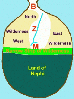
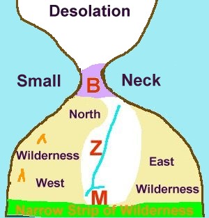
Now what the book says is 'the land of Nephi and the land of Zarahemla were
nearly surrounded by water'. And the ONLY
mention of any connecting land is that 'there being a small neck of land
between the land northward and the land southward.' That is all that it says!
Many who present that their Book of Mormon 'internally generated map' is
true to the book then begin to altar this simple statement by such things
as a 'yah-but' which also does connect land upon the south of the land
of Nephi. The Book of Mormon never does state that. The only connecting land
which the book says anything about is this 'small neck' which leads from
the land southward to the land northward which will be later developed. Other
than that small neck the book says they are surrounded by water which jives
perfectly with Jacob's surmise when he states, 'we are upon an isle of the
sea.' (2 Nephi 10:20)
Later in the Book of Mormon it will speak of four seas, the sea south, the
sea north, the sea west and the sea east (Helaman 3:8). Thus the internal
book seems to support this concept of water surrounding the land southward
with that exception which the book mentions of there bing the small neck of
land between the land north and the land south. From the internal description
of the book no other conclusion many be derived concerning other connection
land. Thus this is the simple image of the internal map in relation to the
land of Zarahemla and the land of Nephi, they are surrounded by water,
surrounded meaning upon all sides, with a small neck of land to the land
north. And the internal book says it was a 'small neck' not a waist size
connection but a 'neck' sized connection to the land north.
|
32 . . . and thus the land of Nephi and
the land of Zarahemla were nearly surrounded by water, there being a small
neck of land between the land northward and the land southward.
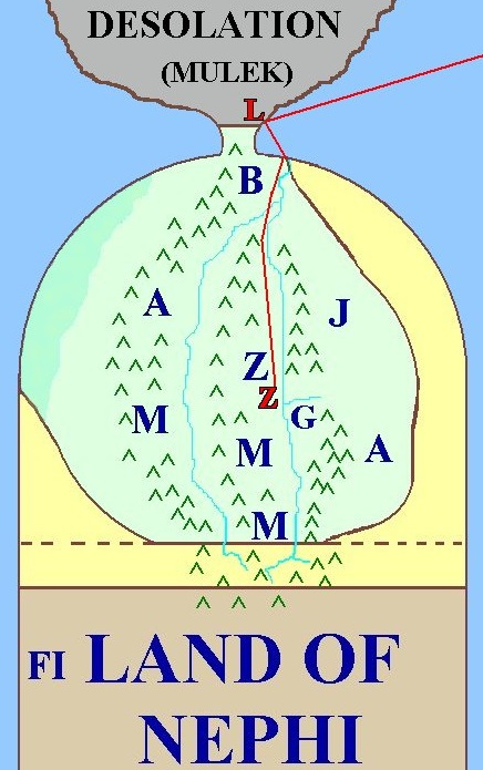
Animation Displays: The land northward of Mulek's landing and
Jaredite Desolation, and the land southward of Lehi or Lehi's Boutiful landing,
and Zarahela and Nephi. North and South divided by a small neck of land, Bountiful.
Land southward consists of nation of Zarahemla and nation of Nephi, divided by
a narrow strip of wilderness between Nephi and Zarahemla.
|
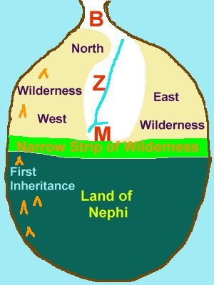
27 And it came to pass that the king sent a proclamation throughout all the land, amongst all his people who were in
all his land, who were in all the regions round about, which was bordering
even to the sea, on the east and on the west, and which was divided from the land of Zarahemla by a narrow strip of
wilderness, which ran from the sea east even to
the sea west, and round about on the borders of
the seashore, and the borders of the wilderness
which was on the north by the land of Zarahemla, through the borders of Manti,
by the head of the river Sidon, running from the east towards the west
—and thus were the Lamanites and the Nephites divided.
|
The first thing to note is that the land of the Lamanite had been occupied
from the sea on the east and on the west in their lands of occupation. This
is the Land of Nephi as named by the Nephites in their records. What divided the land of the Nephites which is called Zarahemla, from the Land of Nephi of the Lamanites, was a 'narrow strip of wilderness.' It will be assumed that the width of this narrow strip at its narrowest measure was comparable to the width of the 'narrow neck' of land mentioned later. Therefore, a day and a half journey for a Nephite might give a point of reference to the width of this narrow strip of land at this juncture. This narrow strip of land 'ran' from the sea east even to the sea west. Again, unless otherwise reported elsewhere, this strip of land will be assumed to be on a line from the west sea to the east sea. The first reported variance is that it was 'round about' on the borders of the seashore. This seems to mean that along the seashore, the Lamanites began to intrude beyond the line between the east and west on into what would have
otherwise been Nephite lands had a straight east to west line been maintained. Also, in addition to the round about intrusion on the seashore. The Lamanites had also began to become located in the wilderness area on northward by the land of Zarahemla. This begins on the borders of Manti located by the headwaters of Sidon on its west side (running from the east towards the west). At this point, it will be recalled that during an earlier war with invading Lamanite forces, these Lamanites were driven into the Wilderness which was west and north of the city of Zarahemla which was called the Wilderness of Hermounts. Unlike the Lamanites, the Nephites had not spread out from sea to sea in their land. Much of their early settlement had been in the large Sidon river valley, and they had not moved on out to secure their coast lines at this juncture in time.
|
|
Now why would the Nephites have allowed the Lamanites to have come and
dwelt in 'their' lands north of the 'narrow strip of wilderness?' First
Zarahemla was in the center or heart of the land. And the earliest
expansions of the Mulekites and the Nephites had been along the Sidon River
in a north-south manner within the confines of the Sidon River valley. And
thus they were not preoccupied with moving in an east-west orientation to the
sea, as none of their rivers provided them that occasion. A side comment is
warranted here. Colonizers and settlers usually do follow river courses in
their settlements. They need the constant supply of fresh water. This fact
suggests that while the river Sidon of the Land of Zarahemla ran in a north
south manner from its headwaters near Manti, the river or rivers of the land
of Nephi might be looked to run east-west. How this happens to occur and
helps in establishing the geography of the land of the Book of Mormon will be
gone into in more detail elsewhere.
This 'rough' initial map is just the first in a series of developing
mappings. It will be refined as additional information is explored.
|
|
28 Now, the more idle part of the Lamanites
lived in the wilderness, and dwelt in tents; and
they were spread through the wilderness on the west, in the land of Nephi
; yea, and also on the west of the land of
Zarahemla, in the borders by the seashore
, and on the west in the land of Nephi, in the place of
their fathers’ first inheritance, and thus bordering along by the seashore
.
|
At this juncture in time, some of the Lamanites had development life-style
patterns of dwelling in cities. Others continued in the traditions of the hunter, gatherer, and scavenger. The prior descriptions of the Lamanites where that they would go about practically naked, eating raw meat, and living in tents. This life style continued for was is termed 'the more idle part of the Lamanites.' These are the ones who spread through the wilderness on the west both in the Land of Nephi and on the west in the wilderness of the land of Zarahemla. It is of interest that the place of their fathers' first inheritance was on the west of the Land of Nephi bordering along by the seashore. This was their first land of settlement from which Nephi had depareted having been warned of the Lord to do so. These nomadic more idle part of Lamanite groups did not seem to be as much threat all alone and by themselves until various forces were wrought to join the Lamanites together against the Nephites. This was always theunifying force that kept the Lamanites one people, was the their hatred for
the Nephites. Otherwise they would have separated into various associations and tribes and began to fight amoungst themselves a lot earlier than they did.
|
Misconceptions of Tradition
: Here, while first presenting
the concept of the 'land of first inheritence', a warning against the
commonality of presuption and tradition will be given. It has been presumed
by readers of the Book of Mormon, which has become a misconception of 'traditional
stance', that the site of Lehi's First Landing and the Land of First
Inheritence are both at the same general location. That is a
presumption based outside of what the book states. Yet the traditional
presumption persists. There is nothing in the Book of Mormon that
substanciates that conclusion that the site of their 'first planting' where
they reaped in abundance is where they stayed and settled. In point of fact
in the 1830 edition of the Book of Mormon where there is no division between
chapters 18 and 19 as we have today, the verse which in condensed abridged
form clearly speaks of Lehi's next 'journeyings' in the land of promise (1
Nephi 18:25) is immediately followed by the next paragraph in the same
chapter explaining that Nephi did engrave upon his large plates further
concerning these 'journeyings', there being more particulary given. This
rather hints that Lehi's party did not settle at the
site of their first landing, but rather then took their journey into the
land of promise's wilderness finding all manner of animals and ores of every
kind as they journeyed. And these details are upon the large plates. And at
the end of that next journey in the land of promise wilderness did Lehi's
party then finally arive at the land of first inheritence on the east of what
would become known as the land of Nephi. Another careless presumption outside
the Book of Mormon is that Lehi's descendants did ever journey northward. The
only thing which fuels this assumption is the notion of a coast of Chili
landing, which is not a part of the internal information of the book either.
Remember Lehi's first journey was some 200 miles from Jerusalem to the
Valley of Lemuel, his second journey was across Saudi Abrabia, his third
journey was across the Indian and Pacific Oceans, and not his 'fourth
journey' in the land of promise was no more than a walk around the block?
That is not consistant to the manner and way the Book of Mormon uses the term
to journey. The concept rather is that for Lehi to journey in the land of
promise he left the site of first landing and traveled on in the wilderness
to where the 'land of first inheritance' where they would then be established
and settled. Many a would be successful coloney has failed just because they
did not further journey and explore the land to find out it resorces and to
settle nearer to where those they'd need were located. Is that not what the
Book of Mormon presents that Lehi's party did?
|
|
The land of their fathers' first inheritance was on the western seashore
of the Land of Nephi. This is where many a Book of Mormon geographer will
make an unsupported assumptive jump. They tie Lehi's Landing site with the
site of the fathers' land of first inheritance. No where in the Book of
Mormon do it support this conclusion. In fact a careful reading of the text
associated with Lehi's Landing Site in the last verses of 1 Nephi 18 will
suggest just the opposite. After Lehi plants and harvest for a growing season
in verse 24 of that chapter, verse 25 of Nephi's 'abridged' small plate
record states that they 'journeyed' in the wildernes. Now a journey to me is
from one place to another, not just exploring the neighborhood. Some see it
differently of course. This will be discussed more later.
What is important here is to note the
location of the 'Land of First Inheritance' and that the more 'idle' part of
the Lamanites dwelt in tents and lived along the western regions of the land
of Zaramhela and of the Land of Nephi.
One last note, this generic bulb shaped map will begin to vary in shape
as other facts are revealed. It is being built from Mormon's records and it
will take on more form and detail as it progresses.
|
|
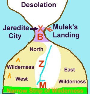
29 And also there were many
Lamanites on the east by the seashore, whither the Nephites had driven them
. And thus the Nephites were nearly surrounded
by the Lamanites; nevertheless the Nephites had
taken possession of all the northern parts of the land bordering on the
wilderness, at the head of the river Sidon, from
the east to the west, round about on the
wilderness side; on the north, even until they came to the land which
they called Bountiful.
|
The Lamanites where also east of Zarahemla having been driven there in battle
with the Nephites. Note here, though not as obviously stated in terms of the war involving Hermounts, the Lamanites are locating in the vacant Nephite lands where the Nephites have driven them in their battles (Alma 2:35-38). The Nephite major emphasis has been to keep the Sidon Valley regions clear without as much concern for the wilderness on the west and the plains and seashore on the east. Thus the Nephites where nearly surrounded on all sides with the exception of the Nephite Sidon River route to the Land of Bountiful in the northern parts. The Nephites had taken possession of all the northern parts bordering on the wilderness. From the head waters of the river Sidon near Manti east and west, all the way back down the Sidon Valley as bordered by the wilderness (Hermounts on the west which we know was west and north of Zarahemla), and round about the river's course and thus on up into Bountiful. In an awkward manner,
Mormon has stated once again that the wilderness of Hermounts pushed in on the
north of Zarahemla. This implies that the River Sidon either flows in a north by northeastern direction over all or at least takes an northeastern turn before it reaches its outlet to the sea. Thus the Mulekite and Nephite settlers who followed the river's course had left the wilderness' direct north-south line through Hermounts between Zarahemla and Bountiful and followed the valley 'round about' going northeast from Zarahemla before, near the seashores, turning back northwest to make their way to Bountiful. This is the 'round about' course described as underlined which is confusing without this assumption clarifying it.
|
~ Bountiful ~
It is important to interrupt here to point out that we are now going to
identify the land of Bountiful with some vary direct and candid statements,
and though they are abridged, they do pin point the land of Bountiful quite well.
Not only that, it directly associates the land of Bountiful with other
previously known, named and significant sites. It is here, that those who
want to limit and compact the lands of the Book of Mormon into neat little
packages divert from their very own methods of operation in failing to note
the significance of these very compacting and confining statements written by
Mormon as a part of his abridgement. How can they miss the obvious? It is
my the means of the same fact that they do not comprehend that Mormon's
record is such an abridged but precise record that they over condense on the
one hand. And then on they other hand they miss the direct inference of such
a precise and direct inference that Mormon's abridgement makes, not allowing
himself to give all the various statements and restatements of the facts in
the matter which an unabridged
accounting would have given with full laborious explanations.
|
~ The Antecedent of
"it" is Bountiful ~
|
|
30 And it [Bountiful]
bordered upon the land which they called Desolation, it [Bountiful] being so far
northward that it came into the land which had been peopled and been
destroyed , of whose bones we have spoken, which
was discovered by the people of Zarahemla,
it
[Bountiful] being
the place of their first landing.
|
Throughout this whole verse the antecedent of the pronoun 'it'
is the proper noun Bountiful last named at the end
of verse 29. 'It' equals 'Bountiful', that is the antecedent of 'it' is
'Bountiful'. When read carefully, Bountiful's northern border
bordered the land called Desolation (Desolation is sometines considered all the land
north of Bountiful though Mormon will later point out that land's name also to be Mulek*
(Helaman 6:10). Mulek would include the far reaches of the lands of the Jaredites.
The Land of Bountiful extended so far north that while it bordered
Desolation, Bountiful came into the southern fringe of the land of bones.
And Bountiful may have included the remains of the Jaredite city which was
in the narrow neck. It being the Jaredite jump off into the preserved land
southward used for hunting expeditions (Ether 10:19-22).
What is said is significant to the People of Zarahemla, the Mulekites, because
it takes them to the land northward for Mulek's landing when Mulek was alive.
Bountiful extended into the land of bones discovered by the Mulekites upon
that first landing. The Mulekite landing was north of the 'narrow neck' but
not so far north that is was not associated with the border of Bountiful.
Bountiful extended into the land of Desolation, to the very point of the
Mulekites landing. This is reasonable from two separate perspectives
beyond the obvious association stated here. How did the Mulekites find
Coriantumr? It is a grim picture of logic and reality that Coriantumr would
have retraced the flight of the Jaredites from the far reaches of the Hill
Ramah in search for life. 'Could it really be that all were dead? Didn't
at least one or two others survive?' Coriantumr had searched in vain
until he came to the 'narrow neck' borders of the southern
wilderness, Bountiful. This
was the logical meeting place of finding Coriantumr. It did not take a great
search. The other point is, where else would the hand of providence, the
Lord whose hand is in all things, have brought the Mulekites but to the place
where the remaining animals of the Jaredites would have fled to for the want
of food. The remaining domestic animals where there, to be gathered up for
their use in the new land?
|
* Mulek: There is a finer point of doctrine that has lead me to consider
that the land northward of the small neck of land needed to be named Mulek
(Helaman 6:10), and why Mulek, the son of King Zedekiah, was specifically
brought to the land north of the small neck of land. This reasoning may
be derived internally from the Book of Mormon and as it also relates to
all scripture. But it is not a particular to be gone into here in building
a simple internal mapping of the Book of Mormon.
|
~ Two or More Landing Sites ~
In verse 30 it states that Bountiful, at least the northern border side
difinition of Bountiful, is where the people of Zarahemla 'first
landed'. Now lets us ask the question, 'if' there was a '1st'
landing does not that imply at least a '2nd' landing and it
certainly does not preclude other 'landings' as well. Who in their right mind
would abandon ship just to settle in a land covered in bones? So what does
that all imply? Might not that imply that from this '1st landing
site' the party of Mulek may not have traveled by land 'up and into' the land
south, but they very well could have sailed up and into it that land via what
they would name the Sidon River. Was not the river Sidon a navigable river?
The Amazon is and the Magdalena is at least a majority or sizable length of
its course. For the people of Mulek to be found in the 'heart of the land'
in the city of Zarahemla rather than upon a coastal area, could they not have
'navigated' their way to the site of their colonial
landing up and into the land south from Bountiful?
Now consider this abridged account of Mormon concerning the lands of landing now
takes a very interesting but almost always missed direction. Mormon has
just recorded the approximate 1st landing site of the Mulekite's
group to be in north Bountiful just a little north of the Isthmus of the
Narrow Neck of land. He completes that thought telling of the Mulekites'
course on up into the land of Zarahemla. And then he gives, in his precise,
candid, pointed condensation of abridged words, the
location of the landing of Lehi's group. Read the following verse before you
read the direct commentary and see if you can pick it out.
|

31 And they came from there up into the south
wilderness. Thus the land on the northward
was called Desolation, and the land on the southward was called
Bountiful, it being the wilderness which
is filled with all manner of wild animals of every kind, a part
of which had come from the land northward for
food.
|
From their landing site, just north of the isthmus, the Mulekites came up,
following, either by foot or by ship, the course of the Sidon River, its
valley, into the heart of the land of Zarahemla. Mormon then restates that
Desolation was northward, not necessarily directly north, and that Bountiful
was southward of their common border. It sounds as though the common border
may not have been a direct east-west line. But now comes the shocker. Ever
want to know where Lehi landed? Mormon tells you right here, 'Bountiful, it
being the wilderness which is filled with all animals of every kind.' There
is only one other place in the entire Book of Mormon which uses this exact
same phraseology, and that is in 1 Nephi 18:25. Ture, Bountiful is also
associate with the wilderness of Hermounts, it being the extended wilderness
of wild animals. But Mormon here takes care to use the same words or
'reformed Egyptian' characters which Nephi used in his record. Why did he
take such care, but to candidly state that this land of Bountiful was the same bounteous land where Lehi landed finding
the animals of every kind? And just as it was the logical providence of God
to bring the Mulekites to where they could gather up the domestic herds of
the Jaredites within the reaches of the 'Isthmus of the Narrow Neck,' so it
was the providence of God to afford Lehi and his group the same convenience
and blessing. Shiz had swept the land before him. Nothing remained. What
domestic animals of the Jaredites where left and able to make their escape,
would have to come into the land south from the land northward for food. This
was the 'second land Bountiful,' so named, where
Lehi's group landed. They had sailed from 'Bountiful' and they had landed
in 'Bountiful.'
From a 'first landing site' north of the small neck of land to the centrally
located city and surrounding immediate lands of the city of Zarahemla, any
well studied Book of Mormon scholar ought to understand that all the other
surrounding Book of Mormon cities and their communites laid round about the
centrally 'heart of the land' city of Zarahemla. So the question becomes how
did Mulek's descendants become so centrally located in the midsts of the land?
|
Now, stop, consider. When I first realized what Mormon was saying in his
abridgment, a thrill traveled my spin and goose bumps formed. Mulek landed a
little north of the Isthmus of the Narrow Neck, likely on the East Coast. And
Lehi landed a little south of the Isthmus of the Narrow Neck of land on the
West Coast. Thus the Lord brought Mulek into the land north and Lehi into the
land south. And while the immediate land just north of the narrow neck was
known as Desolation, the name associated with all the land north was Mulek.
And while the immediate land just south of the narrow neck was known as
Bountiful, the name associated with all the land south was Lehi.(Hel. 6:10)
And 'Lehi' was divided into two great nations recored by the Nephites as
the Land or Nation of Nephi where the Lamanites dwelt having forced the
Nephites to be removed from their first original lands of occupation. And
the other great nation of Lehi was that of Zarahemla which was occupied by
the Nephites and Mulekites during this juncture in time.
|
|
A Small Narrow 'Neck' of Land
|
32 And now, it was only the distance of a day
and a half’s journey for a Nephite, on the line Bountiful and the land
Desolation, from the east to the west sea; and thus the land of Nephi and the land of Zarahemla were nearly
surrounded by water, there being a small neck of land between the land
northward and the land southward.
|
The 'Narrow Neck' was a day and a half's journey for a
Nephite on the line Bountiful and Desolation from the East to the
West Sea. Much is discussed about the size of this width.
Depending on mode and ease of travel it could well range from 45 to well over
100 miles and that was a 90 BC measurement. But there are more telling
matters about the 'small neck of land' than its measured width. First
is
what is next said, if Mormon is taken at his word with no ifs, ands, or buts.
The land of Zarahemla was nearly surrounded by the Lamanites on the south,
east, and west except the Land of Bountiful which led into the narrow
neck of land. Mormon knew what being nearly surrounded meant! The lands of
Nephi and Zarahmela were nearly surrounded by water. There was water to the
east of them, there was water to the west of them, and there was water to the
south of them. Only in the north was this not the case. That is what being
surrounded means! The only exception was the 'small neck of land'
between the land northward and the land southward.
Second, NO LAND TODAY in America fits the
description as it is mapped TODAY. South America is too wide
AS MAPPED TODAY to be the Lands of the Book of Mormon. MesoAmerica is
attached in the south by the Isthmus of Panama AS MAPPED TODAY. Whatever
you conceive as the Lands of the Book of Mormon, they will be significantly
different from how the lands of America map TODAY in 2001 AD. Mormon's
description was of the land of 90 BC, before the destruction at the
Savior's death. A lot of twisting and turning of words with fallacious
manipulations would have to be used to get the Book of Mormon lands to
exactly fit a map today. The Church is wise in not publishing a map.
Lastly, but not least, Mormon says that it is a neck of land not a
waist. A neck is elongated and in verse 30 it said that Bountiful 'came into
the land' of Desolation. Bountiful reached from south of the nap of the neck
where it had sealed off the Lamanites up into the neck until is reached the
lowest regions of the Jaredite remains, the Jaredite City that was by the
narrow neck of land. And the 'neck' was at least as tall as it was wide.
|
Mormon's Abridged 'Time Capsule'
There any number of points to consider in Mormon's 'Time Capsule'
abridged description of the geography of the lands in 90-77 BC. One is that
Mormon lived some 300-400 years removed and after this time and the
destruction at the time of the Savior's death. Another is, Mormon lived over
1600 years before today. While Mormon is trying to remain true to the
description of the land in 90 BC, he also faces the likelihood that it may
not be the same hundreds of years from his time. Another point is in
Mormon's abridged record, not all times and descriptions are to scale as he
is condensing. One tool of this condensation that Mormon uses is the phase,
'And it came to pass.' It usually means that time has passed and removes
what he is about to say from what has been said by an indefinite distinction.
And whether Mormon does this by the nature of abridging the account while
knowing the details or recording the events not knowing the details is beside
the point. It is important to take note that he is using the tool 'And it
came to pass,' to bridge information given in his abridgement. Next we have such a 'And it came to pass.'
|
33 And it came to pass that the Nephites had
inhabited the land Bountiful, even from the east unto the west sea, and thus
the Nephites in their wisdom, with their guards and their armies, had hemmed
in the Lamanites on the south, that thereby they should have no more
possession on the north, that they might not overrun the land northward.
|
Whatever the state of the land of the Nephites at the precise dating of
the King of the Lamanites' proclamation, which Mormon here jumps from, the
Nephites would in short order occupy the narrow neck region of the land of
Bountiful as Mormon indicates with its stated purposes. This occupation
was an evolution in defense of the lands of the Nephites and likely was not
the exact state of the land at the precise time of the proclamation. Mormon
indicates this with the 'refrain,' "And it came to pass." And since this was
more of a military purpose statement, it well may not have been totally the
state of affairs until the time of Captain Moroni, when such needs of securing
the passages to the land north was right at hand. Later it will be further
noted that Mormon's description here is somewhat generalized over a space of
time, as there are other details which are missing from his presentation of
this simple mapping, which Mormon in his abridged Book of Mormon will
add in and further stipulate in other passages.
|
~ Northward and Southward ~
It is now time to the point that we can discuss a little further the
relationship between the land 'northward' and the land 'southward.' The word 'northward' is used every time Mormon refers to the Land North which has been five times. And though it is not as frequently used, as the common perspective is from south to north, the word 'southward' has been used twice from the perspective of north to south. Each of this instances of use you will have noticed, I have underlined the work in the scriptural verses. When something is not precisely north or precisely south in resect to each other, the more generalized words of northward and southward are used. Mormon, or the divinely inspired translation of the Book of Mormon text by the Prophet Joseph Smith, has persistantly given this more generalized aspect to the relationship between the land 'northward' and the land 'southward.' What this indicates is that the relationship between the two lands was somewhat skewed in relationship to each other and not exactly on top of each other in a precise north-south relationship.
~ Northern North Hermounts is Bountiful ~
Another point that is now ready for discussion is the particular term or
phase 'round about.' I associate well with this phrase. Where I live there
is a lake near by called the Great Salt Lake. There are no bridged highways
that transverse across the lake. From Clearfield to a little west of
Stansbury which is a part of my course to work, I have to drive 'round about'
the lake through Farmington, Bountiful, North Salt Lake, and on out I 80 by
Magna before I can arrive a little west of Stansbury. If the would build a
bridged highway across the Great Salt Lake between Clearfield and Stansbury,
my commute to work would be shortened substantially. In relation to the City
of Zarahemla and the immediate land of that city and the Land of Bountiful,
the Nephites would travel 'round about' the wilderness. This wilderness's
name was Hermounts which was both west and north of Zarahemla the locally
regional land about the city Zarahemla proper. The fact that the Mulekites
and Nephites had been prone to settle along the Sidon river and follow
that river valley all the way up to its head waters where Manti was located,
is an indication that the river either runs from southwest to the northeast
or at leas has a 'northeasterly' turn which takes a traveler northeast,
'round about' that portion of the wilderness of Hermounts which is directly
north of the City Lands of Zarahmela which would have to be 'cut' through to
reach Bountiful on a straight north to south line. This adds to the concept of the lands being skewed one from the other. It moves the River Sidon's passage to the east of the north-south line from Zarahemla to Bountiful. It means that there are lands out in that direction including the River Sidon to the east of Bountiful, and it places the 'Isthmus of the Narrow Neck' to the west of the River Sidon's passage to the sea. Thus it has already shown a tendence to skew the land Northward to the west a bit from the traveled routes from the land southward. Further evidence of this skewing is found elsewhere, but it can already be implied from Mormon brief, precise, compacted, and abridged description here in Alma 22.

This last verse is a reiteration and summary statement of the stated
purpose and design of the previous verses. It also is with the coverage of
Mormon's 'And it came to pass' refrain and therefore should be considered
with the same consideration as previously stated. There is no further direct
comment to make in regard to this last verse as it is just an ending summary
statement, and no new information is found in it .
34 Therefore the Lamanites could have no more possessions only in the
land of Nephi, and the wilderness round about. Now this was wisdom in the
Nephites—as the Lamanites were an enemy to them, they would not suffer their
afflictions on every hand, and also
that they might have a country whither they might flee, according to their
desires.
The Nephites where prepared and ready to 'flee' for their lives if ever
the conflict with the Lamanites ever grew to an unmanageable degree. While
stated in conjunction with a report that was being historically given from
the 4th century AD about the time around 90-77 BC, it is Mormon
who states the reasoning of holding the Lamanites back from occupying the
land to the north. This is the same leader of the military of the Nephites
during their last days of existence. The concept of fleeing from the enemy
into other lands was not a foreign concept to Mormon. While this relates to
other considerations covered in respect to Cumorah's last stand, it is
mentioned here just to point out a perspective that Mormon would have.
Mormon would have considered this perspective during the last days when he
was fighting the wars with the Lamanites as it was at this same time that he
was preparing his abridged record from which we read.
|
|