Now in part one a general lay of the land was given including the locating
of the land Bountiful from the information given in Alam 22. And as that
information will now be built upon to further develop the concept of the
land of Bountiful and the narrows of the small neck of land, we must somewhat
dulicate information by thus there beginning with that same information form
Alma 22 which has once been presented. But here we will enlarge upon it and
from other Book of Mormon reference attempt to more throughly build the
greater perspective of just what the land of Bountiful did consist of from
the internal evidences of the Book of Mormon.
It is important to come to a clear understanding of what the Nation of
Zarahemla and the Nation of Nephi are in relationship to the provincial lands
of those two nations and the various cities of those provinces. Now there is
the greater nation of Zarahemla. This point we have identified two with a
third implied provincial division within that greater nation of Zarahemla.
Unforturnately the Book of Mormon is not always clear in deligniating when
it speaks of a national land, a provincial land and an imediate land
belonging to a particular city. And as in any colonization and settlement of
a new nation, these are but progressively being defined, delimited and
created. First we have the nation of Zarahemla, within that nation we have
the provincial lands of that nation, of which we may denote Manti, Zarahemla
and Bountiful as being. Do not become confused, all three are lands belonging
to the Nation of Zarahemla. It is just that Zarahemla is the name of the
entire nation, it is also the name of a small provincial sized land within
that nation and it will further be delimited to a particular city within that
greater nation also named by that same name. In Utah we have Salt Lake City
which is in Salt Lake County, but there are also other cities and town in
Salt Lake County beside just Salt Lake City. Now you may not know but there
is a New York City, there is a New York County and there is a New York
State. This is like Zarahemla City, the Province of Zarahemla and the
Nation of Zarahemla in the Book of Mormon. Interesting about the county of
New York or New York County (one of New York State's 62 counties) is that it
is better known as Manhattan which today is but one of the five boroughs of
New York City. The city of New York has swallowed up its own county as well
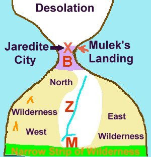
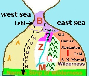
as much more. Anyway in this general Book of Mormon map the
'B' is for Bountiful and its provincial land, the
'Z' for Zarahela's provincial land and the
'M' is for Manti and its land. There are many other
lands and cities in the nation of Zarahemla, but we will eventually get to
those in their own due time. But in the case of the Nation of Nephi we may
already speak of the 'province of the land of first inheritance' as it will
later be seen to likely have its own cities within that province and of
course there is a city of Nephi not to be confused with the greater nation of
Nephi.
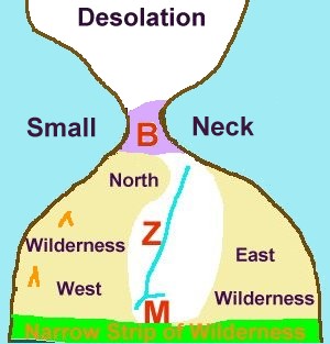
BOUNTIFUL: Province ~ City ~ Cork in the Bottle
BOUTIFUL, CITY OF—Nephite city in land of Bountiful
Alma 52:15, 17 ~ Teancum is based in Bountiful;
Alma 52:27 ~ Lamanites attack Bountiful;
Alma 53:3 ~ ditch dug around Bountiful;
Alma 53:4 ~ Bountiful is encircled with timber wall;
Alma 55:26 ~ prisoners taken to Bountiful;
Helaman 1:23 ~ Coriantumr marches toward Bountiful;
Helaman 5:14 ~ people taught, beginnig at Bountiful.
BOUNTIFUL, LAND OF—Nephite territory [region/province] north of
[provincial land of] Zarahemla
Alma 22:29 ~ Nephites take possession of Bountiful;
Alma 22:31 ~ Bountiful lies south of land of Desolation;
Alma 22:33 ~ Bountiful runs from east to west sea;
Alma 27:22 ~ Bountiful is joined on the southeast by Jershon;
Alma 50:28 ~ Nephites possess land north of Bountiful;
Alma 50:32 ~ Moroni fears people in Bountiful will hearken to Morianton;
Alma 51:28 ~ Nephites driven to borders of Bountiful;
Alma 51:30-32 ~ Amalickiah repulsed from Bountiful;
Alma 52:9 ~ Moroni orders Bountiful fortified;
Alma 52:15, 18 ~ Moroni marches toward Bountiful;
Alma 52:39 ~ Lamanite prisoners taken to Bountiful;
Alma 63:5 ~ Hagoth builds ships in Bountiful;
Helaman 1:28 ~ Lehi sent to defend Bountiful;
Helaman 4:6 ~ Nephites driven into Bountiful;
3 Nephi 3:23 ~ Nephites prepare to defend Bountiful;
3 Nephi 11:1 ~ Christ appears to people gathered at temple in Bountiful.
|
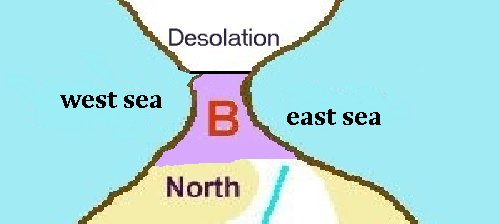
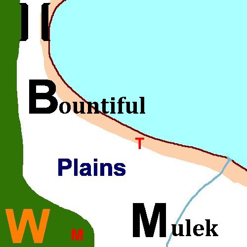
BOUNTIFUL
Bountiful is the quintessential case of a
regional-territorial-province of the nation of the Nephites, the nation of
Zarahemla. The references which refer to Bountiful associate the 'region' of
Bountiful with that of the narrow or small neck of land and that the
northern border of Bountiful runs in a broder line from the sea east to the
sea west with the land of Desolation at the top of the neck of land. Upon
the south Bountiful widens into a 'upside down' cork shape which will border
the land of Jeshon on the southeast, the mystery provincial 'land inbetween'
the provinces of Zarahemla and Bountiful, and it will upon its south flow
into and become a part of the northern wilderness of Hermounts. Then upon the
southwest Bountiful will nearly border the provincial land of Ammonihah and
most likely that inpassible west coast region which has such natural features
to disallow or prohibit human transit by that route by any significant
commonly feasible manner. The Lamanites and their army never attempt to reach
the land of Bountiful, the narrow neck by that route. Also in this section
a number of other particular features and significant points of interest will
also be covered concerning the provincial land of Bountiful and its city
Bountiful which will be clearly established to have been on the east coast.
|
Alma 22
29 And also there were many
Lamanites on the east by the seashore, whither the Nephites had driven them
. And thus the Nephites were nearly surrounded
by the Lamanites; nevertheless the Nephites had
taken possession of all the northern parts of the land bordering on the
wilderness, at the head of the river Sidon, from
the east to the west, round about on the
wilderness side; on the north, even until they came to the land which
they called Bountiful.
|
All that was spoken of in Alma 22 before verse 29 is south of the land they
called Bountiful. That is the provincial land and city of Zarahemla, Manti,
the western wilderness, the eastern wilderness, the river Sidon, the Narrow
Strip of Wilderness, the land of First Inheritance and of couse the Land,
Nation and city of Nephi. If fact one picture painted concerning Bountiful
is that it is like the 'cork' of a corked jug. All that is in the national
Land of Nephi and the national Land of Zarahemla, excepting Bountiful, is
south of and contained in that 'jug' of land surrounded by water. In other
words the land bridge of Bountiful, its small neck of land, is the only
land route out of the lands of Zarahemla and Nephi. And as painted in this
verse, the nation of Zarahemla at this juncture of time is nearly surrounded
by the Lamanites, who are then also surrounded by water with the
exception this land Bountiful which runs from the east sea to the west sea
and stops up the 'jug' of land. Of course this is but the 'general picture'
and as in all generally set out matters there are details not given in the
general perspective.
From the Book of Mormon's perspective a river has two heads or ends. One
head is where the river begins and the Sidon's head waters in that respect
begin in the land of Manti. The other head is actually the 'mouth' of the
river and is where the river empties into the sea. So what is being said in
verse 29 is that the national land of Zarahemla ran from the Sidon's head
waters in Manti on the south and down north including the lands from east to
west as so previously delimited to Bountiful on its north which stopped up
the land and confined it from sea east to sea west in its land 'jug'
surrounded by water.
|
~ Bountiful ~
It is important to interrupt here to point out that we are now going to
identify the land of Bountiful with some vary direct and candid statements,
and though they are abridged, they do pin point the land of Bountiful quite well.
Not only that, it directly associates the land of Bountiful with other
previously known, named and significant sites. It is here, that those who
want to limit and compact the lands of the Book of Mormon into neat little
packages divert from their very own methods of operation in failing to note
the significance of these very compacting and confining statements written by
Mormon as a part of his abridgement. How can they miss the obvious? It is
by the means of these same facts that they do not comprehend that Mormon's
record is such an abridged condensed record, but over simplifiying what they
take as be a 'precise detailed record' their view of the facts as being the
'whole' story that they in theior own irony over condense on the one land.
And then on the other hand they miss the direct inference of such a precise
and direct inference that Mormon's abridgement makes that this is but one
one hundredth part of the whole, not allowing himself to give all the various
statements and restatements of the facts in the matter which an unabridged
accounting would have given with full laborious explanations.
An example of a condensed version of an event is that Lewis and Clark sailed
up the river and crossed the Rockies to the Pacific Ocean. That is a
abridged edition of the Lewis and Clark expedition. Now if you have not a
knowledge of the geography of NOrth America and were Lewis and Clark began
and ended their exploration to the sea, just how precise of a limited view
might you surmise from this simple condensed abridged account of the Lewis and
Clark Expedition? You might decipher it to be but a days boat trip and hike
to the sea. Generally my account is not incorrected, only highly abridged.
And so is Mormon's and his unlike mine has very little known geography to it
with except that is concerns Amereica.
|
|
30 And it [Bountiful]
bordered upon the land which they called
Desolation, it [Bountiful]
being so far northward that it came into the land which had been
peopled and been destroyed, of whose bones we have spoken,
which was discovered by the people of Zarahemla,
it [Bountiful] being
the place of their [people of Zaarahemla] first landing.
|
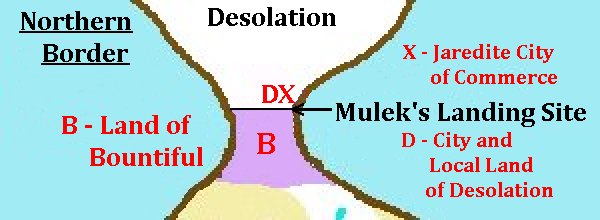
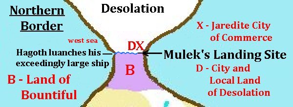
The Northern Border of Bountiful
THE CORK'S TOP: Now when read carefully there is much to be found in this sentence as
supported also elsewhere in the Book of Mormon. First we are told of the
northern border of Bountiful. The land Bountiful extended 'SO FAR
NORTHWARD', implying an elongated small across neck, that it came into
the land called Desolation. Now this 'border' between Bountiful and
Desolation is upon a 'line' from east sea to west sea and must still be
of that of the northern bound of the small neck of land, for in verse 32
it denotes that upon this border line a Nephite could cross, it being 'only
the distance of a day and a half journey for that Nephite.
MULEK'S LANDING: Here again, it is also important to recognize that
this whole verse is speaking about 'Bountiful'. That is, the pronoun
'IT' refers only to Bountiful which was introduced in verse 29. In the
1830 Book of Mormon, rather than verses, the whole of this is all in one long
paragraph, which more closely associates the pronoun 'it' to its antecedant
Bountiful than might be recognized by the division of verses. And when the
antecedent of 'it' is thus properly recognized as 'Bountiful', then the place
of the people of Zarahemla's landing is fully substantiated. It being the
top of the Bountiful cork, likely upon its east coast as denoted in the map.
And if one takes the time and effort to 'connect the dots' of the Mulekite
landing at this particular place of the once great city of commerce of the
Jaredites, the Jaredite jumping off place into the natural preserve of the
south to obtain game, with the fact that they also found Coriantumr, 'the
last Jaredite' (other than Ether) there at that site of their landing, then
one can ponder just what Coriantumr (Omni 1:21 and Ether 15) was doing there
'waiting for them' to appear. Had Coriantumr in his mental agony of seeking
after anyone who may have escaped the annihilation of his people journeyed to
that furtherest city south from where hunting parties may have ventured into
the land southward and may yet still return?
MASSIVE CITY OF BONES: Now briefly concerning the land of Desolation,
at the point of Alma 22 in the Book of Mormon, the name Desolation did
reference the whole of the land northward consisting of the dead dried bones
of the Jaredites. The one particular city of bones which the people of
Zarahemla or the Mulekites may well have found harbor at is that great city
of trade and commerce stated by the Book of Mormon as having been built at
that very junction where the 'narrow neck of land' leads down into the land
southward which the Jaredites has preserved in its ecological wilderness state
that they might hunt in for game, NOT that they would not ever venture into
it.
THE CITY OF DESOLATION Later a 'provincial' or 'city' land of Desolation will also be noted which
only is confined to the city and land of Desolation immediately upon the
border of Bountiful (Mormon 3:7; 4:2) and Desolation, the rest of the greater
land of Desolation having by then been further subdivided into other lands
and cities of the Nephites as they had settled and occupied the land.
THE NORTHERN BORDER: Now in summary, the northern border of the nation
of Zarahemla is the provincial land of Bountiful which on the north borders
the Land of Desolation of the Jaredites. It is where the Jaredites built a
great city of trade and commerce. It is were Mulek's party first landed
finding Coriantumr. It is where Mormon would lead the Nephites in their
defense against the Lamanites in the local land of Desolation from a Nephite
fortress city of Desolation.
|
|
Ether 10
|
20 And they built a great city by the narrow neck
of land, by the place where the sea divides the land.
21 And they did preserve the land southward for a wilderness, to get game.
And the whole face of the land northward was covered with inhabitants.
22 And they were exceedingly industrious, and they did buy and sell and
traffic one with another , that they might get gain.
|
|
Mormon 3
|
5 And it came to pass that I did cause my people that they should gather
themselves together at the land of Desolation, to a city which was in the
borders, by the narrow pass which led into the land southward.
...
7 And it came to pass that in the three hundred and sixty and first year the
Lamanites did come down to the city of Desolation to battle against us;...
|
~ Lehi's Landing Site ~
Having disclosed the landing location for the people of Zarahemla to have
been upon the northern border of Bountiful where the bones of the Jaredites
did lay upon the land of Desolation, why didn't Mormon also disclose
the landing site of Lehi? Or did he? Mormon may have given it in the lost 116
pages, but also here Mormon may well have given enough information whereby
one astute enough might deduce it though it is most always missed even by the
most careful Book of Mormon student. In addition to giving an enroad into
Mulek's party venturing into the south wilderness, Mormon also further
identifies the southern reaches of the land of Bountiful as being that very
wilderness filled with 'all manner of wild animals of every kind'. And
this is were we'll commence with structuring the southern border of the land
of Bountiful. Oh by the way, if you have missed it, Bountiful is bordered on
the east and on the west by the east sea and the west sea, which will be
mentioned in various places in the Book of Mormon.
|
31 And they [the people of Zarahemla-Mulek's
landing party] came from there up into the south wilderness. Thus the land on the northward
was called Desolation, and the land on the southward was called
Bountiful, it being the wilderness which
is filled with all manner of wild animals of
every kind, a part
of which had come from the land northward for
food.

|
Thus the Mulekites from their landing site upon the northern border of
Bountiful, just north or just at the northern end of the 'narrow neck'
isthmus, came 'up' and 'into' the south wilderness lands which the Jaredites
had preserved. Did Coriantumr help lead them? Did they travel the land route
of the small neck of land or did they sail there way even up the great Sidon
river to the very site of Zarahemla at which they would be found by the
Nephites? In either respect Mormon returns to his defining of and speaking of
Bountiful. Mormon restates that the line between the land northward and the
land southward is where the land Desolation of the north borders the land
called Bountiful on the south. He then further identifies Bountiful as being
'the wilderness' that was filled with 'all manner of wild animals of
every kind'. He further states that part of those animals had come from the
land northward for the want of food. And why wouldn't they if Shiz had
persued his scorched earth design of sweeping the land clean before him?
By identifying Bountiful with that land, that specific 'wilderness', which was
filled with 'all manner of wild animals of every kind', Mormon has now
associated three previously unassociated lands. The land and wilderness
associated with Lehi's landing, the land of Bountiful and the wilderness of
Hermounts. In only one other place is this exact phraseology definition
repeated and that is in 1 Nephi 18:25 where Nephi speaks of the land
wilderness into which his party did journey after they had landed upon the
land of promise. And conceptually this wilderness 'filled' or 'infested' with
wild animals or beasts is also associated with the wilderness of Hermounts
which was to the north and west of the 'provincial' land of Zarahemla.
Cetainly it was not north west of the nation of Zarahemla for Hermounts would
be apart of that nation just as Bountiful and Manti were also.
Now when looking at the mapping of the land of Zarahemla with Bountiful and
Hermounts placed upon it, it is easy to see how the southern bounds of
Bountiful would reach down and into the wilderness of Hermounts with both
Hermounts and Bountiful being upon the north of the provincial land of
Zarahemla as presented in Alma chapter 2. Now what made the 'wild animals'
which filled the wilderness suddenly becoming 'ravenous beasts' and an
infestation rather than a 'filled population' is likely the fact that they
were in Alma chapter 2 eating people. They had become 'man eaters' of the
dead, scattered and lost Lamanites who had been driven in amongst them.
It may come as a surprise that Mormon has given us the information that is
actually telling us where Lehi landed. But consider the logic of it from the
internal evidence and facts of the Book of Mormon and please put aside the
misconceptions of common tradition. Lehi had just left a land they called
Bountiful because it was bounteous and when Lehi reached the promised land
he has come to a second 'Bountiful' land which yielded a bounteous crop from
their first planting in the land of promise. The association of the names
Bountiful seem to identify in it own logic where Lehi landed. He landed in
the land they did call Bountiful. Second item of logic, is just were did all
those domestic animals come from which Lehi found wandering in the wilderness
among the wild animals? Only the Jaredites could have brought them back to
this land with them and from the Jaredites in the land north they did wander
for want of food (Alma 22:31) from the land northward into the top of the
land southward where they were to be found by Lehi's party and also likely
Mulek's party as well. Those are two supporting logical reasons. Forget about
the misconception of a landing site on the coast of Chili. That is not internal to
the Book of Mormon. What is internal to the Book of Momron is that the Book of
Mormon identifies Lehi's wilderness, Bountiful's wilderness as well as the
wilderness of Hermounts as being the wilderness filled or infested with wild
animals. That is internal information and on a map it fits. And it fits the
logic of the matter according to the Book of Mormon. And now if we can so
associate Lehi's landing with Bountiful and at least northern Hermounts with
Bountiful, we are ready to procede with an internal 'mapping' of the southern
border of the provincial land of Bountiful.
Consider that Mormon seems to have taken care to use the same words or even
'reformed Egyptian' characters which Nephi used in 1 Nephi 18:25 in his
record of Alma 22:32. Why? Did he candidly state that this land of Bountiful
was the same bounteous land where Lehi landed finding the animals of every
kind? Or had Mormon as a part of the lost abridgment of Nephi's large plates
also have referenced it there as well and perhaps even more clearly?
It was further the logical providence of God to bring the Mulekites to where
they could gather up the domestic herds of the Jaredites within the reaches
of the 'Isthmus of the Narrow Neck,' so it was also the providence of God to
afford Lehi and his group the same convenience and blessing. Shiz had swept
the land before him. Nothing remained in the land north, not even forest of
trees. What domestic animals of the Jaredites where left and able to make
their escape, would have to come into the land south from the land northward
for food. This is all logical and internally deduced from the Book of Mormon.
|
|
1 Nephi 18
|
25 And it came to pass that we did find upon the land of promise, as we
journeyed in the wilderness, that there were beasts in the forest of
every kind, both the cow and the ox, and the ass and the horse, and the
goat and the wild goat, and all manner of wild
animals, which were for the use of men. ...
|
|
Alma 2
|
37 Yea, they were met on every hand, and slain and driven, until they were
scattered on the west, and on the north, until they had reached the
wilderness, which was called Hermounts, and it was that part of the
wilderness which was infested by wild and ravenous beasts.
|
Lets Review
Now, stop, consider. When I first realized what Mormon was saying in his
abridgment, a thrill traveled my spin and goose bumps formed. Mulek landed a
little north of the Isthmus of the Narrow Neck, likely on the East Coast. And
Lehi landed a little south of the Isthmus of the Narrow Neck of land on the
West Coast. Thus the Lord brought Mulek into the land north and Lehi into the
land south. And while the immediate land just north of the narrow neck was
known as Desolation, the name associated with all the land north was Mulek.
And while the immediate land just south of the narrow neck was known as
Bountiful, the name associated with all the land south was Lehi.(Hel. 6:10)
And 'Lehi' was divided into two great nations recored by the Nephites as
the Land or Nation of Nephi where the Lamanites dwelt having forced the
Nephites to be removed from their first original lands of occupation. And
the other great nation of Lehi was that of Zarahemla which was occupied by
the Nephites and Mulekites during this juncture in time.
|
A Small 'Neck' ~ A Narrow
'Neck' of Land
Before we continue onto the forming of the southern borders of Bountiful, lets
explore in greater detail the concept of a 'small neck' of land as it relates
to the northern border on that line between Bountiful and Desolation. A small
neck is not a fat neck little alone a 'waist' size neck. It is a 'neck', an
isthmus between two other significantly larger 'lands' which would in
comparison to the connectiong 'neck of land' lead the prepares of the Book of
Mormon record to reference it as being 'small' and 'narrow'. That is the true
internal geography picture. Too often it is forgotten when attempting
to confine the Book of Mormon to any predisposed concelpts of today to a
known geography of the lands of America. And it is exactly what any
objectively minded person ought not to do, to let outside geography influence
the criteria placed upon the statement of geography made internally by the
Book of Mormon in producing an 'internal map' of the Book of Mormon lands.
Lets keep the 'small' and 'narrow' neck just that, small and narrow!
|
32 And now, it was only the distance of a day
and a half�s journey for a Nephite, on the line Bountiful and the land
Desolation, from the east to the west sea; and thus the land of Nephi and the land of Zarahemla were nearly
surrounded by water, there being a small neck of land between the land
northward and the land southward.
|
The width of the 'Narrow Neck' on the border line between Bountiful and
Desloation was 'a day and a half's journey for a Nephite' from the east to
the west Sea. Much is discussed about the width of this neck but
how often is outside geography explored that would allow such a
crossing 'from the east to the west sea'? Could there be some
geological feature which would aid in such a crossing from east to west
rather than from west to east? If it were down hill from the eastern starting
point to the west sea it certainly might be easier than crossing 'up hill'.
As to available means of crossing, Zulu warriors were able to jog/march for
50 miles in a day and then fight a battle at the end of his march. On their
return trip by boat down the Missouri River during September 1806, Lewis and
Clark descended the river at a rate of over 70 miles per day, that is upwards
of 75 miles per day. The pony express riders could cover by horse back the
distance from Placerville to St. Joseph, some 2,700 miles, in just over ten
days; an average of just over 11 miles an hour on a 24 hour a day clock
considering continual relay motion of the express night and day. That is some
390-400 miles in a 36 hour day and a half by horse back. That's as great
as some limited models of Book of Mormon geography make of the distance of
the whole of their landscape from south to north in their limited model
map. Now while that extreme may not be the case of the width of the 'small'
and 'narrow' neck, one may at least consider what is appropriate in terms
of a 'small' and 'narrow' neck in comparison to the land on either side
of it. If the small neck is say 75-100 miles wide, then the land north and
south ought to be significantly wider to make it relatively a 'small neck' of
a 100 miles when compared to those lands it connects. By the way, William
Dampier in his book reported that an indiginous Indian could transverse the
width of the Darien Isthmus in a day and a half. I presume from east
to west utilizing an east to west flowing river of the Darien. Thus
depending on mode of travel and ease of travel, the small/narrow neck could
range from 45 (30 miles per day) to well over 100 miles. That width would
have been a 90 BC measurement.
Now whether Moronihah's line in Helaman 4 was one from coast to coast or
perhaps just from a natural barier on the east to the west sea along the
'line which they had fortified, it ought not effect the considered width of
the small or narrow neck. For again, Buffalo Bill made the longest and
fastest non-stop pony express ride from Red Buttes Station to Rocky Ridge
Station when he found that his relief rider had been killed. The distance was
322 miles completed in 21 hours and 40 minutes, under one day's time. Of
course he used 21 horses to do it. And then also the longest ride apart from
speed by one rider was made by Jack Keetley. It was 340 miles in 31 hours
without stopping to rest or eat. At the end of his ride he was taken from the
saddle sound asleep at Seneca, Kansas. So if a Nephite had such 24 hour
access to horse relay or a descending river system, why couldn't he easily
tranverse a narrow neck 50 to 100+ miles wide in one 24 hour day's time? Even
Lewis and Clark's day was but from dawn to dusk descending the Missouri river.
And one last item concerning the land of north Bountiful which seems to tie
into this day and a half travel across the isthmus neck. It is upon its west
coast, likely somewhat above where Lehi would have landed, that Hagoth, just
in side the Bountiful border near the land Desolation did launch
his 'exceedingly large' ship, there being some type of deep harbor,
perhaps where that travel aiding east to west river did flow into it.
|
|
Helaman 4
|
6 And the Nephites and the armies of Moronihah were driven even into the
land of Bountiful;
7 And there they did fortify against the Lamanites, from the west sea, even
unto the east; it being a day's journey for a Nephite, on the line which
they had fortified and stationed their armies to defend their north country.
|
|
Alma 63
|
5 And it came to pass that Hagoth, he being an exceedingly curious man,
therefore he went forth and built him an exceedingly large ship, on the
borders of the land Bountiful, by the land of Desolation, and launched it
forth into the west sea, by the narrow neck which led into the land
northward.
|
Mormon's Highly Condensed and Abridged Record
When considerting the Book of Mormon geography one 'MUST'
understanding that the record of Mormon is only one one hundredth part of
a complete record. There are many places and points missing. And often to
even gain a 'relationary' understanding of the Book of Mormon lands, a person
must 'piece meal' a picture together. And even then, that picture obtained
will be very much lacking. One of the greatest errors of construction a
Book of Mormon geography is the fault and the result of the 'quick read'.
We may be able to construct a 'simple' geography with its relationships, but
we must always consider and remember that it is but a fractional part of that
land and we must consider that given the actual additional pieces that are
missing in our abridged record, the actual land of the Book of Mormon will
not only be vastly increased in detail but also likely in actual size. Such
will be the case as we continue to construct our picture of Bountiful, the
city and the land thereof. Now before we go on to various added scriptures,
let us now again first finish with Alma 22 and what it has to say about
Bountiful.
|
33 And it came to pass that the Nephites had
inhabited the land Bountiful, even from the east unto the west sea,
and thus the Nephites in their wisdom, with their guards and their armies,
had hemmed in the Lamanites on the south, that
thereby they should have no more possession on the north,
that they might not overrun the land
northward.
|
As we continue to structure the land of Bountiful, though we have already
mentioned that it bordered from sea to sea and was a day and a half's
journey distance for a Nephite upon its northern border with Desolation from
sea to sea, we will here further develop the fact that Bountiful was that
land of the neck and down into the northern section of the national lands of
Zarahemla being so inhabited by the Nephites from sea to sea. Certainly by
the day of Hagoth there was a port/harbor deep enough on its northwestern
corner to allow Hagoth to set an 'exceedingly large' ship afloat into the
sea west. And there would logically be a 'city of Hagoth' though we are not
ever given to know its precise name in Mormon's abridged record. And here
before we part from the Alma chapter 22 description of the land Bountiful,
it becomes important to note that 'the Nephites had inhabited the land
Bountiful, even from the east unto the west sea', thus 'hemming in the
Lamanites on the south'. Thus as a cork blocks the opening of a bottle, so
the land Bountiful did 'plug' and secure the land passage access to the land
northward from Lamanite access. And thus we have defined three borders to
the land Bountiful, the land of Desolation upon the northern border, the west
sea upon the western border and the east sea upon the eastern border. And now
we will continue to develop this perspective and become somewhat more familiar
with just what is upon the southern border of Bountiful beyond it being a
part of the national lands of Zarahemla.
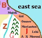
To help to establish the southern border of Bountiful, beginning
at the southeastern corner of the land, we turn to an account of the
defensive cities developed and reinforced which lay upon the eastern seashore
of the national land of Zarahemla. In Alma 51:26 it lists these cities
with one exception, which is one of the few legitimate 'errors' to be found
in the Book of Mormon conceivably made by its abridger Mormon. Without
going into detail, Mormon lists 'Nephihah' as one of the east coast cities
taken by Amalickiah. In truth Amalickiah never did take Nephihah (Alma 51:25)
but he did take Moroni, which is the correct city which properly completes the
list. This is likely an error of abridgment and one of the man made
errors warned against by Moroni. Nephihah would be taken later
by Amalickiah's brother Ammoron after Amalikiah's death. Here is a map
approximating these cities of the east coast to enable us to further define
the southeastern border of the land Bountiful.
The Lamanites had taken the city of Mulek. The next city they attempted
to take along the east coast was the city of Bountiful, but Teancum
withstood them and they retreated to the city of Mulek. After Teancum had
slain Amalickiah a military leader named Jacob assumed command of the
Lamanite armies. Moroni and Lehi came to the aid of Teancum to
attempt to twart the Lamanite attack against the cities of the east seashore.
The Lamanite purpose was to gain access to the passage of the narrow
neck to the land northward. As recorded in Alma 52, Moroni had Teancum take
his men down near the seashore by the city Mulek. The Lamanites came out to
attack Teancum. Teancum retreated northward along the eastern seashore until
he and the attacking Lamanites came near to the city of Bountiful. Now apart
from the exciting military action, what is important here is the relationship
between Mulek, Bountiful, the east sea coast and the narrow neck land of
Bountiful. That the city Bountiful was in the land of Bountiful and located
upon the east sea coast is established here as Teancum was persued northward
along that eastern coast from Mulek and until he and the Lamanites had come
near to the city of Bountiful. As for the city of Mulek, whether it was
a part of the land of Bountiful or not, it is not stated. The City of Mulek
and the immediate city land of Mulek was either in the province of Bountiful
or in that province southeast of the province of Bountiful. What we have
established is that Bountiful was upon the east coast in the southeast corner
of the province of Bountiful and next near the city of Mulek, which was also
upon the eastern sea coast.
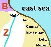
As pictured in the map at the left, the city of Bountiful was north along
the eastern seashore from the city of Mulek. Also shown is that to the west
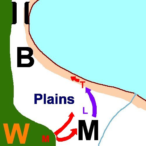 of the city of Mulek was a wilderness, which wilderness we may presume to
be that of 'Hermounts' which we will speak of later. The map now to the right
illustrates the action of Teancum retreating northward along the seashore to
the city of Bountiful and being persued by the Lamanite armies while Moroni
attacks and takes the city of Mulek while almost the whole extent of the
armies of the Lamanites are in pursuit of Teancum.
of the city of Mulek was a wilderness, which wilderness we may presume to
be that of 'Hermounts' which we will speak of later. The map now to the right
illustrates the action of Teancum retreating northward along the seashore to
the city of Bountiful and being persued by the Lamanite armies while Moroni
attacks and takes the city of Mulek while almost the whole extent of the
armies of the Lamanites are in pursuit of Teancum.
Having now established the location of the city of Bountiful of the provincial
land of Bountiful, we will briefly address the concept of 'provinces' of
the greater national lands of Zarahemla.
|
|
Alma 51
|
26 And thus he (Amalickiah) went on, taking possession of many cities, the
city of Nephihah [Moroni], and the city of Lehi, and
the city of Morianton, and the city of Omner, and the city of Gid, and the
city of Mulek, all of which were on the east borders by the seashore.
|
|
Alma 52
|
22 Therefore he [captain Mormon] caused that Teancum should take a small
number of men and march down near the seashore; and Moroni and his army,
by night, marched inthe wilderness, on the west of the city Mulek; and thus,
on the morrow, when the guards of the Lamanites had discovered Teancum, they
ran and told it unto Jacob, their leader.
23 And it came to pass that the armies of the Lamanites did march forth
against Teancum ... And as Teancum saw the armies of teh Lamanites coming out
against him he began to retreat down by the seashore, northward.
27 And it came to pass that the Lamanites did pursue Teancum until they came
near the city of Bountiful, and then they were met by Lehi and a small army,
which had been left to protect the city Bountiful.
|
~ Concept of Provincial or Regional Lands ~
Having established a relationsip between the cities of Bountiful and Mulek
upon the northeastern coast of the national land of Zarahemla,
we now turn to address the topic of provinces or land regions of the nation
of Zarahmela. This is done in order to further identify the nature of the
southern border of the provincial land of Bountiful. We have
thus far identified Bountiful with the narrow neck and that in its
southeastern corner lies the city of Bountiful. Bountiful is therefore both
the name of the larger regional lands of Bountiful which fill the narrow neck
and the northern portion of the national lands of Zarahemla which plugs the
land passage to the land northward. As to the concept of there being a
regional division of the national land of Zarahemla, a suggested list is here
givenwithout detailed references as that will be
so detailed later in developing this internal map of the Book
of Mormon. We do this to enable us to introduce the province or region
of Jershon, which we will find butts against the southeastern border of the
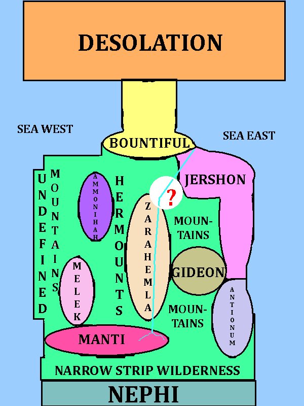 province of Bountiful. There may have been at one point seven provinces
associated with the seven churches (Mosiah 25:23) or church centers
in the land of Zarahemla. Alma seems to have ordered his missionary efforts
in line with these seven regional centers with their chief judge and
church center. To put names to these in general, there is the central region
of the province of Zarahemla in the central Sidon valley, the province of
Gideon in the valley of Gideon, the province of Melek in the upper valley
over the mountain in the parallel valley west of Zarahemla, the province of
Ammonihah in that parallel valley's lower region, the regional land of
Bountiful north of Zarahemla, the regional land of Manti in the upper Sidon
valley and highlands, the province of Jershon east of Zarahemla beyond the
mountains east of Zarahemla and beyond the valley of Gideon which would be
one route to it, and the Zoramite province named Antionum to the south east.
That is seven provincial lands surrounding Zarahemla with the province of
Zarahemla making an eighth region. On a 'block map' these regions and land
features would in relationship to each other something like the illustration.
Each will be further developed and resourced. For now the immortant
relationship will be that between Bountiful and Jershon.
province of Bountiful. There may have been at one point seven provinces
associated with the seven churches (Mosiah 25:23) or church centers
in the land of Zarahemla. Alma seems to have ordered his missionary efforts
in line with these seven regional centers with their chief judge and
church center. To put names to these in general, there is the central region
of the province of Zarahemla in the central Sidon valley, the province of
Gideon in the valley of Gideon, the province of Melek in the upper valley
over the mountain in the parallel valley west of Zarahemla, the province of
Ammonihah in that parallel valley's lower region, the regional land of
Bountiful north of Zarahemla, the regional land of Manti in the upper Sidon
valley and highlands, the province of Jershon east of Zarahemla beyond the
mountains east of Zarahemla and beyond the valley of Gideon which would be
one route to it, and the Zoramite province named Antionum to the south east.
That is seven provincial lands surrounding Zarahemla with the province of
Zarahemla making an eighth region. On a 'block map' these regions and land
features would in relationship to each other something like the illustration.
Each will be further developed and resourced. For now the immortant
relationship will be that between Bountiful and Jershon.
The actual size and porportion of the regions will vary in reality. This is
an approximated diagram map of the suggested regional provinces of
the nation of Zarahemla. Whether there were seven regions as
matching the seven churches with seven governmental centers including or
excluding the central capital city and region of Zarahemla. This is
speculative. Certainly any developing dynamic national community changes.
Whether the land between Zarahemla and Bountiful -?-
was developed sooner or later is not known.
|
|
Alma 27: JERSHON &
BOUNTIFUL
|
|
22 And it came to pass that the voice of the people came, saying:
Behold, we will give up the land of Jershon, which is on the east by the sea,
which joins the land Bountiful, which is on the south of the land Bountiful,
and this land Jershon is the land which we will give unto our brethren for an
inheritance.
|
When on his missionary tour of the regional provinces of the land of
Zarahemla, Alma, first time he was thrown out of Ammonihah, was on his
way to the next provincial land whose capital city was Aaron. He had
visited the provinces of Zarahemla, Gideon and Melek with success. The
capital city of the province of Ammonihah had expelled him from the land.
And he was going over to the province where Aaron was the chief city when an
angel stopped him and told him to return to Ammonihah. We never again hear
of Alma going to the province where Aaron was the capital city. Why not?
Well after Alma finished in Ammonihah the second time, he went home to rest
with Amulek. Then the Lamanities came in and destoryed Ammonihah. The other
Nephites repell those Lamanites and the next actual mission we here Alma
traveling to is south to Manti and when on his way there he meets the
returning sons of Mosiah from their Lamanite missions with the converted
Lamanites in tow. After all the discussion the Nephites give the land or
province of Jershon to the Lamanites. There is reason to believe that the
city Aaron was the capital city of that province as it is so located on what
would be the south of Jershon on a line with Nephihah and Moroni so
protecting the new southeastern Nephite border. Remember the Zoramites of
Antionum defected and became Lamanites and thus the province of Antionum
defalted to and became part of the national lands of Nephi of the Lamanites.
From the city of Aaron, Moroni had set up a defense line to the east sea
coast with the new cities of Nephihah and Moroni and then round about upon
that sea coast with the cities of Lehi, Morianton, Omner Gid and Mulek to
Bountiful. The only question is where does the line between Bountiful and
Jershon fall? A presumption must be made and all the defensive cities as
shown on the map at the left will be illustrated as falling in the province
of Jershon except for Mulek and of course the city of Bountiful itself.
Now the 'A' and the 'N' before the city of Moroni on the map are of couse
for the cities of Aaron and Nephihah. They would make a line, set by captain
Moroni, of defense upon the southern border of Jershon alone that border with
Antionum, which had fallen away to the Lamanites as the land of the defecting
Zoramites. Some will attemp to divide the city of Nephihah from the plains
of Nephihah, but as Alma 62:18 establishes, they are of the same land, city
and plains area.
The joining southeastern border of Bountiful is now estabished as ajoining
or bordering with that of northern Jershon. As depicted in the small map
at the right, the cities of Gid, Omner, Morianton, Lehi, Moroni, Nephihah and
Aaron have been assigned to this provincial land. Mulek on the other hand
has been assigned to the province of Bountiful and as depected is associated
with the river Sidon. Remember the Mulekites may have accessed the interior
of the land south by waterway, the river Sidon up and into the land to where
they built and established Zarahemla. Whether the city Mulek was so also
established by the Mulekites as one of their cities, we do not have that
information in the Book of Mormon, but the name Mulek itself does suggest it.
As for the 'G' and the little green mountains, remember both the Sidon river
would have been in a water basin within mountains and the land of Gideon is
so stated as a valley between mountains running off to the east from the
Sidon drainage valley.
|
|
Alma 50
|
14 And they also began a foundation for a city between the city of Moroni and
the city of Aaron, joining the borders of Aaron and Moroni; and they called
the name of the city, or the land, Nephihah.
|
|
Alma 62
|
18 And it came to pass that when they had sent them away they pursued their
march towards the land of Nephihah. And it came to pass that when they had
come to the city of Nephihah, they did pitch their tents in the plains of
Nephihah, which is near the city of Nephihah.
|
|
~ North Hermounts & Bountiful ~
Hugh Nibley considers the name Hermounts to be taken from 'Hr-Mntw'
meaning 'wild animal country' or 'Month's country. Perhaps I'm just being an
over simplified man, but in translated English 'Her-mounts' could be a
descriptive term for 'twin mountain peaks' from an obvious application of the
female anatomy applied to mountains. Again the limited model theoriest
revel in the fact that Tehuantepec means 'Hill or Mountain of the
Fierce or man eating Beasts'. That's something to think about, yet I would
suppose that there are countless regions and lands around the world where
the wild wilderness places are called by some such name that references the
place of wild animals as the 'wilderness, hill or mountain of wild beasts',
particularly those societies which are hunters and gathers, who would be
particularly mindful of such areas which so abound in wild and dangerous
beasts, be they mountain lions, tigers, bears, wolves and so on. It seems a
bit dramatic to so force a whole book's mapping into relationship to such a
local land just because that place has a 'place of wild beasts' so
stipulated. I guess I am just back to the name 'Her-mounts' being what it
appears to be in English. I am developing an 'internal map' after all.
Now the word Hermounts only appears once in the Book of Mormon in Alma
chapter 2 which will again be displayed, but has already discussed. A part of
this Hermounts wilderness filled with wild beasts was to the north of the
 regional land of Zarahemla, the other portion being to the west. And the
association between northern Hermounts being associated with southern
Bountiful has also been made, along with the fact that this appears to be
the same wilderness arena in which Lehi's group did journey in finding there
all manner of animals of every kind at that time, including domestic beasts
which had wandered into the land through the narrow neck of land for the
want of food. Since Lehi's journey in the land of promise took him south
to the land of first inheritance (Alma 22:28), which was on the east of the
land of Nephi,
Lehi's party must have journeyed the full length of the wilderness from
north to south. Remember in Lehi's day there were no western cities or lands
of Ammoniah, Melek and Manti. It was all still wilderness and a part of that
wilderness of wild animals from Bountiful to and through the narrow strip of
wilderness and down south to the eastern coastal region of the land of Nephi.
It is a misconception that has but traditionally been presumed that from Lehi's
landing site the Nephites have ever traveled northward until ending up at
Cumorah. This likely was a result of the presumed landing site of Chili. The
Book of Mormon never does state that, but it does state that Lehi's party
did journey in a wilderness filled with wild beast of every kind and that
wilderness has here been associated with 'Hermounts' which runs from north
to south away beyond the borders of the land of Zarahemla on its west, which
if journeyed in and followed by Lehi's party would take them south from
their landing sight on the west coast of south Bountiful and thence across
that narrow strip of wilderness into the Land of Nephi. At least that is the
internal inference of the Book of Mormon from the book alone and not based
upon any preconcieved notion from outside sources.
regional land of Zarahemla, the other portion being to the west. And the
association between northern Hermounts being associated with southern
Bountiful has also been made, along with the fact that this appears to be
the same wilderness arena in which Lehi's group did journey in finding there
all manner of animals of every kind at that time, including domestic beasts
which had wandered into the land through the narrow neck of land for the
want of food. Since Lehi's journey in the land of promise took him south
to the land of first inheritance (Alma 22:28), which was on the east of the
land of Nephi,
Lehi's party must have journeyed the full length of the wilderness from
north to south. Remember in Lehi's day there were no western cities or lands
of Ammoniah, Melek and Manti. It was all still wilderness and a part of that
wilderness of wild animals from Bountiful to and through the narrow strip of
wilderness and down south to the eastern coastal region of the land of Nephi.
It is a misconception that has but traditionally been presumed that from Lehi's
landing site the Nephites have ever traveled northward until ending up at
Cumorah. This likely was a result of the presumed landing site of Chili. The
Book of Mormon never does state that, but it does state that Lehi's party
did journey in a wilderness filled with wild beast of every kind and that
wilderness has here been associated with 'Hermounts' which runs from north
to south away beyond the borders of the land of Zarahemla on its west, which
if journeyed in and followed by Lehi's party would take them south from
their landing sight on the west coast of south Bountiful and thence across
that narrow strip of wilderness into the Land of Nephi. At least that is the
internal inference of the Book of Mormon from the book alone and not based
upon any preconcieved notion from outside sources.
And thus before further proceeding we have again associated the southern
border of the land of Bountiful with the northern reaches of the wilderness
of Hermounts, the ajoining one unto the other. We have also displayed in Alma
52:22 that Moroni hid his army in the wilderness to the west of Mulek. And
the illustrated map related to that event had also so placed that wilderness
west of Mulek as being south of at least the city of Bountiful and so that
wilderness of Hermounts also so fits as being south of Bountiful and west of
Mulek. But is it only Jershon on the southeaster border of Bountiful and
Hermounts on the rest of the southern border of Bountiful to the west sea
where Lehi landed, he being brought into the land south? Or is there another
land which also borders on the south border of Bountiful? That is the next
question '?'.
|
|
Alma 2: HERMOUNTS,
'?', & BOUNTIFUL
|
|
36 And they fled before the Nephites toward the wilderness
which was west and north, away beyond the borders of the land;
and the Nephites did pursue them with their might, and did slay them.
37 Yea, they were met on every hand, and slain and driven, until
they were scattered on the west, and on the north, until they had reached
the wilderness, which was called Hermounts, and it was that part of the
wilderness which was infested by wild and ravenous beast.
|
All that was spoken of in Alma 22:27-29 before the introduction of Bountiful
at the very end of verse 29 is south of that land they called Bountiful. That
is the provincial land and city of Zarahemla, Manti, the western wilderness,
the eastern wilderness, the river Sidon, the Narrow Strip of Wilderness, the
land of First Inheritance and of couse the Land, Nation and city of Nephi. In
fact one picture painted concerning Bountiful is that it is like the 'cork'
of a corked jug. All that is in the national Land of Nephi and the national
Land of Zarahemla, excepting Bountiful, is south of and contained in that
'jug' of land surrounded by water. In other words the land bridge of
Bountiful, its small narrow neck of land, is the only land route out of the
lands of Zarahemla and Nephi. And as painted in this verse, the nation of
Zarahemla at this juncture of time is nearly surrounded by the Lamanites, who
are then also surrounded by water with the exception this land Bountiful
which runs from the east sea to the west sea and stops up the 'jug' of land.
Of course this is but the 'general picture' and as in all generally set out
matters there are details not given in the general perspective.
From the Book of Mormon's perspective a river has two heads or ends. One
head is where the river begins and the Sidon's head waters in that respect
begin in the land of Manti. The other head is actually the 'mouth' of the
river and is where the river empties into the sea. So what is being said in
verse 29 is that the national land of Zarahemla ran from the Sidon's head
waters in Manti on the south and down north including the lands from east to
west as so previously delimited to Bountiful on its north which stopped up
the land and confined it from sea east to sea west in its land 'jug'
surrounded by water.
As the Book of Mormon never mentions any other persons other than those of
Lehi and Mulek and the Jaredites which became extinct, despite various
external opinions, and the fact that the Jaredites had maintained the land
southward as a natural wilderness preserve, we must presume that prior to
Lehi's and Mulek's landing the whole of the land south was but a wilderness.
By the time of Alma, certain community settlements had been established
variously 'dotting' the wildernes with pockets of civilization. We have so
mentioned seven or eight such provincial 'pockets' of lands so situated in
the nartional lands of Zarahemla. But it ought to be mentioned that between
these provincial centers with their associated cities and towns, the
wilderness still existed and 'surrounded' and 'divided' in most cases these
provinces as indeed mountain ranges and other physical features of the once
entire wilderness still wove an interconnected famework of wilderness housing
these population centers. When Alma went to Gideon, it was in a separate
valley which ran away east from the Sidon valley. When Alma went 'over' and
'into' the land of Melek west of the provincial land of Zarahemla, it too
represented the western Sidon valley range being crossed and then into that
parallel valley which would house the provinces of Melek and Ammonihah. What
was between these provinces? Mountains and wilderness, the western mountain
range of Sidon between Zarahemla and Melek. Three days of likely down
river travel through wilderness from Melek to Ammonihah. And to the west and
north of the province of Zarahemla, besides these two exceptions of the
pocketed provinces of Melek and Ammonihah, was primarily were the wilderness
remained called Hermounts, the wilderness of the mountians containing the
wild beast, 'away beyond the borders of the land'.
This geological feature of Hermounts, that wilderness west and north which did
still predominate, was of necessity north between Bountiful and Zarahemla.
Southern Bountiful actually being a part of it. Now if the Sidon River was
a chief navigable river, it and its banks and shores would carve a natural
pathway through such wilderness where pockets of some degree of civilization
could be established almost continuously to the sea. And if Hermounts was that
continuous wilderness north and west of Zarahemla, then the river pathway of
Sidon logically passed to the east of it and thence to the sea. This is why
in Helaman 1:28 it states that Moronihah 'sent forth Lehi with an army
ROUND ABOUT to head them (Coriantumr's Lamanites) before they should
come to the land Bountiful.' Lehi did not travel 'round about' in the
wilderness of Hermounts to Bountiful, but 'round about' by way of Sidon
river passage toward the sea and then thence toward Bountiful in order to
head or stop the Lamanite invasion. And since Coriantumr's invading Lamanites
were progrssing through the 'capital parts of the land' taking time to
slaughter men, women and children of many cities and strongholds, it paints
a picture of a very populated land trailing northeast along the Sidon river
course northeast above Zarahemla. And this land 'between' Bountiful and
Zarahemla, NOT Hermounts the wilderness directly north of Zarahemla, but that
land between which followed the course of the Sidon river pathway 'round
about' northeast and then along that sea shore between Mulek and Bountiful
was most likely another land and province which bordered the land of
Bountiful's southern border.
Now as to whether our mystery "?" land was just 'near' or bordered against
the lands of Bountiful and Zarahemla we will leave as to the diference in time
and development of lands as the description in Helaman 4:5's of about 38-30
B.C. and 3 Nephi 3's times of 16-18 A.D. (some 50 years) may account for the
fact of when it actually came to border Bountiful. But by Mormon's day, it was
one continual concourse of civilized occupation when 'the whole face of the
land had become covered with buildings' (Mormon 1:7).
Now thus, depending upon points and times of developmental evolution, the
southern border of Bountiful may be meagerly represented as share borders with
Jershon on the furtherest southeast, then next the mystery land which is
spoken of and alluded to but never plainly identified by name though there
are additional names which may be so associated with it which go unassociated
such as Angola and David (Mormon 2:2-5); and the land and wilderness of Hermounts, which is actually
a part of Bountiful on the south and likely up into the narrows and thus
the cause of the narrow passages. Now whether other such development further
brings other lands in contact with Bountiful upon the south, is beyond the
highly condensed and abridged text of the Book of Mormon. Some may suggest a
location for Joshua (Mormon 2:6)as such, but the Book of Mormon does not
fully disclose that. (Note: Joshua is a land, but it is also the same name as
Jesus, Jesus being the Greek form of the Hebrew name of Joshua. Thus other
than Joshua is a Land in Mormon 2:6, it could be associated with Jesus' visit.)
One final note, in considering Lachoneus' choice of Bountiful, our mystery
land between, and the provincial land of Zarahemla to defend against the
Gadianton band of robbers, the geography which he chose to protect is likely
most significant; it being that of the central Sidon river valley north to and
including the narrow neck of land of Bountiful. All of which had physical
features such as seas, river(s), mountains and wildernesses to aid in the
Nephites' defense.
|
|
Helaman 1
|
23 And now he did not tarry in the land of Zarahemla, but he did march forth
with a large army, even towards the city of Bountiful; for it was his
determination to go forth and cut his way through with the sword, that he
might obtain the north parts of the land.
. . .
27 But behold, the Lamanites were not frightened according to his desire, but
they had come into the center of the land, and had taken the capital city
which was the city of Zarahemla, and were marching through the most capital
parts of the land, slaying the people with a great slaughter, both men,
women, and children, taking possession of many cities and of many strongholds.
28 But when Moronihah had discovered this, he immediately sent forth Lehi
with an army round about to head them before they should come to the land
Bountiful.
29 And thus he did; and he did head them before they came to the land
Bountiful, and gave unto them battle, insomuch that they began to retreat
back towards the land of Zarahemla.
|
|
Helaman 4
|
5 And in the fifty and seventh year they did come down against the
Nephites to battle, and they did commence the work of death; yea, insomuch
that in the fifty and eighth year of the reign of the judges they succeeded
in obtaining possession of the land of Zarahemla; yea, and also all the
lands, even unto the land which was near the land of
Bountiful.
|
|
3 Nephi 3
|
23 And the land which was appointed was the land of Zarahemla, and
the land which was between the land of Zarahemla and the
land Bountiful, yea, to the
line which was between the land Bountiful and the land Desolation.
|
Much has been set forth and/or proposed here concerning the provincial
land of Bountiful. Many will put it together differently. The only real virtue
that can be stated concerning this presentation is that it wholey and honestly
has developed it from an internal reading of the text without any precieved
attempt to conform its development to an existing external location or base
it upon any external evidence. Occasionaly an external source will be
mentioned but only in an attempt to show that such external items are NOT
being used to develop this internal map. Also it will be noticed by those who
are familiar with other attempts to generate such a Book of Mormon map and
their outcomes, there will be and are a number of similiar and like features
of development. But hopely where they may have wandered to an attempt to
locate their map to a known location this attempt will not. And when one
considers what has been developed here, and the attempt at total objectivity
and some of the unique items which may appear compared with other such
attempts, some difinite benefit will be found therein.
But now we turn to such as not offended considered which from an objective
perspective may be of benefit in this presentation. We Have actually
developed a territorial border lined picture of the province of Bountiful.
We have set out what is upon its borders, north, south, east and west and
we have developed what such known events and cities are located. But now
we at this point turn internally to the interior of Bountiful.
|
|
Helaman 4 ~ BOUNTIFUL
INTERIOR
|
|
6 And the Nephites and the armies of Moronihah were driven even into the
land of Bountiful;
7 And there they did fortify against the Lamanites, from the west sea,
even unto the east; it being a day's journey for a Nephite, on the line
which they had fortified and stattioned their armies to defend their
north country.
|
In this particular defense of the Nephites a number of items ought to be
noticed, first the Lamanites have driven the Nephite forces 'into the land
of Bountiful'. They are no longer upon the south border, nor are they yet
arrived at the north border, they are in Bountiful's interior at some point
as to north and south borders. Now as to east and west borders, a close
examination of verse 7 establishes where they are in that respect. And as
stated there, they are 'from the west sea, even unto the east. Before we have
dealt with the Lamanites attempting to gain access to the north upon the
east coast and by and or through that avenue protected by the city of
Bountiful. It is an important thing to take note that they are not attempting
here to go through the city Bountiful which had been highly forticated and
defensed in the pass. Rather they are coming in upon the west and upon the
interior of the land of Bountiful. And as verse 7 puts it, 'from the west
sea to the east on the line fortified being a day's journey for a
Nephite'.
Moronhah has here established a defensive line running from the west sea
east for about a day's journey for a Nephite. It is important to understand
that this 'defensive line' is not the same as the northern border line which
extended from the east sea to the west sea and was that entire northern
border line between the land Bountiful and the land of Desolation from sea
to sea. Here it is but a defensive line with the west sea being upon its
western flank and most likely some other natural feature such as a mountain
line of wilderness flanking the line upon the east. Now, neither should the
day's journey for a Nephi be directly comparable to the day and a half's
journey upon Bountiful's norther border. There the direction was specifically
stated to be from east to west and likely used the natural terain, perhaps
an westward flowing river to aid in the transversing of the entire neck. Here
it only measures the width of Moronihah's defensive line, transversing the
whole of the neck not being the purpose, but to detail only the width of
that particular defensive line and likely not with the aid of a flowing
river in either direction as it is more likely the journey time from end of
defensive line to the other end of the defensive line in either direction and
may not even been that of a 24 hour day as the day and a half's journey was
certainly based upon a 36 hour clock. This defensive line's day's journey
may well have been but a 12 hour daylight journey's distance. So any
comparison will likely fail to render an accurate picture.
With that being said, we now have an interior location where the west sea
line inland is accessible to the east on such a defensive line until it does
reach an eastern physical natural barier (mountain range/wilderness). Also
one ought to consider just what type of defensive line did Moronihah
establish? Was it just a line of soldiers on an open flat landscape? Likely
not. Did captian Moronihah put up some type of actual physical manmade
feature to aid in his defense, be it digging in or in suring a high gound
advantage of some type? I would conceivabley think so. At least he would have
so selected his defensive line's location to best take advantage of the
Lamanites by that position he would take his stand upon. Now whether any such
remains by exist of that day's wide defensive position who is to say. I guess
a part of that would be just what natural land feature may have been a part
of it and/or just how extensive were Moroni's efforts in constructing it? In
either case, we can certainly depicted it upon our internal map as having
existed at his particular time whatever the details of it were. Thus for
some say 20 miles across, give or take, for a day's journey Moronihah's
defensive line did stretch from the sea west or near about to the east until
it reached another delimiting geographic feature upon its east end.
Best left to this point is another feature of the land of Bountiful which is
most misunderstood and largely interpreted to fit the actual land location to
which the mapper is attempting a fit. Its terminology can be confusing. It
is found in Alma 50 where Teancum has come and is able to head off the people
of Morianton's attempt to depart into the land northward. The troublesome
descriptions deals with the borders of the land Desolation. and the further
identification of the 'narrow pass'. We have already established that the
distance of that border line between Bountiful and Desolation was a day and
a half's journey for a Nephite, perhaps even a 36 hour concertive effort
journey. That hardly matches a 'narrow passage' which is located upon 'the
sea'. To start which sea and the verse stipulated both seas which are a day
and a half's journey apart. Here I must draw upon my experience, not to the
extend of developing an external map but applying what is possible and
feasible here. I could hardly be accused of trying to fit a Book of Mormon
mapping to the land of New Zealan, could I?
While in New Zealand I became familiar with a feature of sea coasts which
does likely occur around the world. Upon the west coast of the top of the
North Island there is a beach which is named 'Ninty Mile Beach', though the
beach really only extends for about 60 miles. The thing is that at low tide
the beach widens wide enough and solid enough to allow a car to drive upon
it for the greater distance of the beach's length all along by the retreated
sea. It was the smoothest and easiest route to the northern cape's lighthouse
for the interior road was hilly, winding, dusty and rough. Now if the
interior of the land did not so allow easy passage by land on the northern
border with Desolatin and Bountiful, then just perhaps there was such a
narrow path access which ran by the sea, both upon the west and on the east.
That would mean two passages, one upon each sea coast at low tide. Of course
such seasonal events of an El Nino on the west coast or it being huricane
season on the east coast may also effect the accesses to these two passage as
well as wet and dry seasons also.
Many have tangled with this verse of Alma chapter 50. Some come away with
understanding there were two such passages, one on the west and one on the
east. Others have often, in attempting to fit to their preconcieved notion of
where Bountiful was, determined there being but one passage that went from the
west sea to the east sea across the narrow neck. In attempting a subjective
internal map, I'd have to agree with those who see two passages, one on each
sea. Otherwise, the Lamanite attempt up the center of the land with a
defensive line by Moronihah might find conflict with the single narrow passge
itself. And before we leave this point, I would have to state that many
see this as an narrow passage between mountains, a mountain pass. But how
that is also by the sea I don't know. But I do know about passages upon
the seas shore by the sea at low tide. And that to me best fits this internal
description of 'the narrow pass, which led by the sea', be it one such
seasonal and tidal passage by the west sea and by the east sea. And to me it
seems funny to cross the entire width of the Bountiful and Desolation border
from east to west or west to east, just to cross the border from south to
north, from the one land to the other land. It would be like walking the
entire borderline from sea to sea for a day and a half's Nephite's journey
just to cross a borderline. From an internal objective perspective is just
does not make sense. I don't think I'd have to transverse the length of the
Rio Grande just to get from Mexico to Texas?
|
|
Alma 50
|
34 And it came to pass that they did not head them until they had come to the
borders of the land Desolation; and there they did head them, by the narrow
pass which led by the sea into the land northward, yes, by the sea,
on the west and on the east.
|
Now much has been presented concerning the land of Bountiful here. There are
two more features, one which cannot be located for sure and that is the
Temple of Bountiful. One might think that it would be in Bountiful city,
a prime nomination, but the Book of Mormon does not so stipulate which city
in the provincial land of Bountiful the temple of Bountiful was located. I
would suppose it would be in an very populated area to warrent the building
of a temple, but just were that was we do not have enough information in the
highly condensed abrided Book of Mormon to determine.
The other feature is a nebulous matter though likely quite real. And that is
'land change'. In verses already listed it may be seen to be occuring from
the perspective of the land of Bountiful. In the Jaredite abridged record in
Ether 10 verse 20 it speaks of the 'narrow neck of land' where their city
was built, that is was the place where the sea divides the land. That may
have been some hundreds of years before the landing of Lehi and the Nephites.
Some 500 years after the landing of Lehi in Alma 22:32 is speaks of the
width of the small neck of land as being the distance of a day and a half's
journey for a Nephite on the border line between Disolation and Bountiful
from sea to sea. That well may indicate an increase is land width from the
time of the Jaredite city to that time of Alma 22, about 80 B.C. What might
be going on? Well if one considers that the geological changes which did
precede the great destruction during the time of the visit of Jesus to
America in the Book of Mormon, which did cause vast changes in the landscape
in the matter of three days, then could there not have been some degree of
general land movements and upheavals going on over hundreds of years before
then which may have widened the small neck from the size where the sea
would at times over run the land connection to when that land connection
between the land northward and southward had developed to being many miles
wide and in altitude raised up from being at sea level? Or is one to merely
consider that the vast destruction of the time of Christ visit was not
led up to by foreshadowing geological development over time. This will be
a topic further discussed elsewhere in so developing the Book of Mormon
Internal Map.
|
We are ready to sum up. The last verse of Alma chapter 22's presentation of
the nature of the land states what seems to be the primary designated purpose
of the Land Bountiful
This last verse is a reiteration and summary statement of the stated
purpose and design of the previous verses. It also is with the coverage of
Mormon's 'And it came to pass' refrain and therefore should be considered
with the same consideration as previously stated. There is no further direct
comment to make in regard to this last verse as it is just an ending summary
statement, and no new information is found in it .
34 Therefore the Lamanites could have no more possessions only in the
land of Nephi, and the wilderness round about. Now this was wisdom in the
Nephites�as the Lamanites were an enemy to them, they would not suffer their
afflictions on every hand, and also
that they might have a country whither they might flee, according to their
desires.
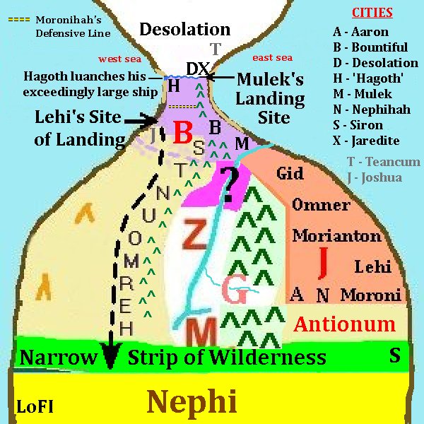 Here now is a summary mapping of Bountiful and other features which will be
further developed in other sections. From the Land of First Inheritance and
Nephi on the south to the land of Desolation of the Jaredites on the north,
the national land of Zarahemla is in parts depicted with Bountiful at the
northern top of the nation acting as the cork of protive land ever guarding
the passage to the land northward.
Here now is a summary mapping of Bountiful and other features which will be
further developed in other sections. From the Land of First Inheritance and
Nephi on the south to the land of Desolation of the Jaredites on the north,
the national land of Zarahemla is in parts depicted with Bountiful at the
northern top of the nation acting as the cork of protive land ever guarding
the passage to the land northward.
In terms of the occurances of the last years of the Nephites under
'General Mormon' it is well to point out that the Nephites had ever ben and
were prepared and ready to 'flee' for their lives if ever the need and
the conflict with the Lamanites ever grew to an unmanageable degree. While
stated in conjunction with a report that was being historically given from
the 4th century AD about the time around 90-77 BC, it is Mormon
who states the reasoning of holding the Lamanites back from occupying the
land to the north. This is the same leader of the military of the Nephites
during their last days of existence. The concept of fleeing from the enemy
into other lands was not a foreign concept to Mormon. While this relates to
other considerations covered in respect to Cumorah's last stand, it is
mentioned here just to point out a perspective that Mormon would have.
Mormon would have considered this perspective during the last days when he
was fighting the wars with the Lamanites as it was at this same time that he
was preparing his abridged record from which we read.
Placement of the Sidon River
As seen in this last map the Sidon river has been more specifically placed.
There are three factors in relationship to the defining of the Land Bountiful
that has led to this placement of the Sidon River. The FIRST
consideration is that of the nature of the wilderness of Hermounts in
relation to Bountiful, Zarahemla and then also the Sidon river. The wildernss
of Hermounts was a continuous wildernes west and continuing around and upon
the north of Zarahemla, whereas the Sidon river was a corridor to civilization
into the center of the national land of Zarahemla from the sea. It was a
great and grand river and gave access to settlement deep into the interior
of the nation of Zarahemla all along its shores. It would have been a
brake or breach to a continuous wilderness such as Hermounts was. Thus FIRST
of all, the river Sidon did not flow straight north through that wilderness
of Hermounts nor did it turn to the west and brake through the wilderness in
that direction. If it had it would not only have broken up that wilderness in
two, but it would have allowed the escaping Lamanities and avenue of retreat
and escape from the pursuing Nephites of Alma's army. Rather therefore the
Sidon river turned to the northeast in it couse to the sea, thus preserving
the continuous nature or the Hermount wilderness and effectively stranding the
fleeing Lamanites in a dense forested jungle or rain forest making them
easy prey for the man eating beasts of that wilderness. The second factor
which supports the northwest nature of the lower Sidon river rather than it
just jutting off to the east, is that course which Lehi took when commanded
by captain Moronihah to head and stop the Lamanite invasion. He traveled
round about following the course of that River to enable his army to out
flank the Lamanite invaders under the command of Coriantumr. Of course he
was not able to travel directly north to Bountiful through the wilderness of
Hermount for the same reason that that wilderness acted as a death trap to
the fleeing Lamanites eariler. He most advantageous course was to follow
that avenue that the Sidon river corridor did allow. And that was northwest
toward the city and land of Melek via the Sidon river. The THIRD and possibly
FOURTH factors, they being presented at the same juncture, is that the
wilderness of Hermounts was ended west of Melek, that is where captain
Moroni had secreted his army while Teancum has positioned himself down
by the sea. So we Know that by Melek the continuous wilderness of Hermounts
is ended and ended by the corridor presented by the Sidon river which was
thus also nigh unto Mulek. And as to which side of Mulek it did pass upon,
we need merely to consider Teancum's positioning and the Lamanite armies
pursuit of him all along the sea shore until they came nigh unto the city of
Bountiful. There was no break in the Lamanite armies agression toward and
after Teancum from the city of Mulek north and west all that way to Bountiful
thus the Sidon river did not pass west of Mulek, though being nigh unto it.
But the Sidon river did pass east of Mulek, emptying into the sea there at
the city named Mulek appropriately after Mulek the son of King Zedekiah and
likely in association to it being a city upon the mouth of the Sidon river
water way which the party of Mulek could utilized in order to sail their
ships all the way into the interior of the land to establish such an
inland capital city such as Zarahemla so far inland upon the west bank of
the river Sidon where it was so located. For these reasons, number them as
you may, the course of the river Sidon comes down from the highland head
waters of Manti upon the south and flows northward past the land of Minon,
passed the eastern valley of Gideon which likely furnished it a major
tributary to the Sidon, passed the city of Zarahemla, through and passed that
mystery land between Bountiful and Zarahemla—it also being on that
'round about' northeastward course for though being between Bountiful and
Zarahemla, it was not on a line south to north also becuase of the location
of the wilderness of Hermounts immediately to the north—and thence past on
on the east of the end of the wilderness of Hermounts, it being that cause of
its end, and finally entering the sea nigh unto the city of Mulek upon its
east side as so just denoted and also shown in the illustrated internally
develop mapping of it. And there between Mulek of Bountiful and the border of
the land of Jershon does the river make an effective border between the land
of Bountiful upon its north and Jershon upon its south.
[NOTE: There were three avenues through the national land of Zarahemla to the
narrow neck of Bountiful. One was upon the east coast via the cities of
Moroni, Lehi, Morianton, Omner, Gid, Mulek and Bountiful. Another was that
course which the Lamanite Coriantumr did attempt to lead his men through the
center of the land, the valley of Sidon north. And the third was that which
the 43 explorers of King Limhi used which was the reverse of the route that
Lehi's party took down into the land of first inheritance in the land of
Nephi. And it was also that which the Lamanites had found when they destoryed
Ammonihah and later attempted to access but were repelled by Lehi at the city
of Noah. Of course the provinces of Melek and Ammonihah, little alone those
southwestern defensive cities, were not there in that parallel valley passage
in the day of
Lehi on his journey down into what would become the land of Nephi. These are
the three avenues attempted by the Lamanites to fight there way to the
northern land passage to the land northward. The Lamanites never did
attempt to run the length of the west coast for the reason that we must
presume, that such natural features of the land along that western coast
were in themselves prohibitive. Moroni had placed only one defensive city
down by the sea coast on the southwest and that was more likely to prevent
the Lamanites from easily flanking him upon the west rather than as an
actual protective city to any west coastal route to the land Bountiful.]
|
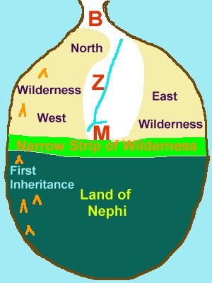 And now so that this discussion may build upon that presented in part one,
a map of the land in general as there presented will here be posted in part
two. This map will aid in the further development of the land Bountiful and
the narrows of the small neck of land. And we quote from Alma 22:28:
And now so that this discussion may build upon that presented in part one,
a map of the land in general as there presented will here be posted in part
two. This map will aid in the further development of the land Bountiful and
the narrows of the small neck of land. And we quote from Alma 22:28: