 Science teaches that the earth was once one land. Science
states it was millions of years ago. Science concedes there
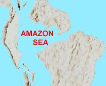
was once an Amazon Sea with an outlet to the Pacific Ocean in the
Lake Titicaca region, again tens of thousands of years ago. Now, if science is
wrong about the last time the earth was one land, then it is
also wrong about when the Amazon Sea existed. It existed between when the
land was divided and today. Upon this logic the Book of Mormon Geography is presented.
Science teaches that the earth was once one land. Science
states it was millions of years ago. Science concedes there
was once an Amazon Sea with an outlet to the Pacific Ocean in the
Lake Titicaca region, again tens of thousands of years ago. Now, if science is
wrong about the last time the earth was one land, then it is
also wrong about when the Amazon Sea existed. It existed between when the
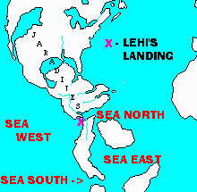
land was divided and today. Upon this logic the Book of Mormon Geography is presented.The Amazon Basin housed the Sea East of the Book of Mormon. The South American Continent did not break off as one big chunk from Africa. The eastern island(s) of South America did split from Africa. The continent we see today was caused by the land plates divided from the east meeting or colliding with the western plates. The Cauca or Nazca western plate's eastern edge forms part of the 'Ring of Fire' of which Colombia, Ecuador, and Peru are a part with the hundreds of volcanoes residing there. The merging land plates forced by the division along the Volcanic Atlantic Ridge, formed the land resulting in the Andean uplift along the eastern edge of the western plate. The Andean unplift has caused ancient corn fields to be lifted up to altitudes where the corn no longer germinates. There are such corn field terraces about the Lake Titicaca region. The great effects of these colliding plates is what was experienced at the great destructions recorded in the Book of Mormon at the death of Christ. During our Biblical past, the earth was much more dynamic and active than it is today. The Bible teaches of the earth's history and says so and the Book of Mormon supports it. It is difficult to predict the exact appearance of the lands and uplifts from the dividing date to the great colliding destruction at the death of Christ. A couple of suggested graphics are presented. The 'X' on the left map marks Lehi's landing sight stated in the Teachings of the Prophet Joseph Smith, 'a little south of the Isthmus of Darien (Panama).' Jacob's Isle of the sea included much of Colombia, Ecuador, and Peru.
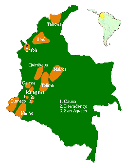
(Note independent map below showing ancient Colombian civilization sites.)
Aaron: City and Land of, Plateau areas near Bogota bordering Orinoco Plains
Ammonihah: Land and City, 3 days travel in Cauca River Valley north of Melek
Amulon: Southern Ecuador region, opposite site from Helam
Antionum: Zoramite land in south east Zarahemla fell to Lamanites during Zoramite dissension
Antiparah: Southern Frontier city of defense between Manti and City by Seashore
Antum: Land of, Near Yukatan - Land of the Hill Shim where records were once stored
Boaz: Land and City beyond Lands of Desolation, Teancum and others - a defensible narrow neck - Honduras Bay
Bountiful: City of, Near east coast standing in line of Narrow Pass to Desolation
Bountiful: Land of, Narrow Neck region of Northern Colombia and Southern Panama
City by Seashore: On West coast of Colombia, west of Manti (San Agustin), not strategic per west coast swamps
Cumeni: Southern Frontier city of defense between Manti and City by Seashore
Desolation: Land and City of, roughly the Central Panama area
Desolation: Nation of, All of Inhabitable North America
Hagoth's Departure: A little south of the Isthmus of Darien in Land of Bountiful near Lehi's Landing
Helam: Southern Ecuador region
Her-mounts: Forested mountains of the western and central Cordilleras of Colombia
Hill Cumorah: Hill Cumorah in New York State - Same as hill Ramah
Jacobugath, Gimgimno, Josh, Gadiomnah, Laman: A few Cities & lands past and destroyed during Mormon's Nephite retreat
Jaredite Landing: Land Northward - generally - assume Pacific coastal area from Oriental side
Jershon: Land and Plains of Orinoco to sea east - Defensed by Nephihah
Jordan: Land of, Isthmus of Tehuantepc - the last defensible narrows land northward
Joshua: City on upper west coast of land of Zarahemla near Hagoth's departure site
Judea: Southern Frontier city of defense between Manti and City by Seashore
Land Northward/Mulek: All of inhabitable North America greatly changed from how it is today
Land Southward/Lehi : Colombia, Ecuador, Peru (The Land South Peninsula - Jacob's Island of the Sea)
Land of First Inheritance: West Coastal lands of Peru - NOT the same site as Lehi's Landing
Land of Zelph: Illinois region - White people of Ammon Lamanite - righteous warrior of war
Lehi, Morianton, Gid, Mulek, Omner: Cities - Lands of defense south & east of Bountiful-mid to upper Zarahemla East Coast
Lehi's Landing: A little south of the Isthmus of Darien (Panama) - Land Bountiful West Coast
Lehi-Nephi: City and Land, northern Peru sites NOT the same place as City of Nephi, but in Land of Lehi-Nephi
Limhi's Party: Party route takes the Cauca Valley missing Zarahemla
Manti: City and Land, in upper Magdalena head waters around San Agustin, Colombia
Melek: Land of, Over Central Cordillera of Colombia and into upper Cuaca River Valley
Minon: Land and City of, next regional land south of regional land of Zarahemla
Moroni: East Coast on Amazon Sea, swallowed by earthquake in sea - covered over
Mulek's Landing: East coast of Land Northward, suggest Central America via Phoenician ships
Narrow Neck: Lower Panama Neck (Darien) - Skewed to left/west of Colombia as is today
Narrow Pass: On the west and on the east at low tide, beach passages to Land Northward
Narrow Strip: Between Zarahemla/Colombia and Nephi/Ecuador-Peru, as Narrow Neck width
Nephi: City of, Chavin de Huantar, Peru - City of refuge where temple like Solomon's
Nephi: Land of, Eventually most of Ecuador and all of Peru to coast of Eastern Sea
Nephihah: City, Land and Plains of, western Orinoco Plains down to sea east - the Greater Amazon Sea.
Noah: 'Twin' city to Ammonihah, people related to King Noah.(see above)
Onidah: Onidah, the place of arms (Alma 47:5), with its introducing hill of Onidah and city of Onidah (Alma 32:4 & 3 Ne. 9:7) and to it's immediate north of its 'dogleg' cupping hand that frames the southeastern border is the land of Antionum with the eastern wilderness to the east down to the Sea East where the Lamanites did so dwell and compus round about on the east of the nation of Zarahemla on the east. It may be associated with what is today the Colombian national park lands and range known as the Sierra De La Macarena. (see Onidah web page.") In journeying first to the southeast out of the land of Antionum, Zerahemnah went to the east 'round about' the mountain range of Onidah to reach a point that he could turn west and up and 'over into' to travel up and over toward and into the upper valley where the land of Manti was located. This gave Moroni's army a direct march route from the city he left on the southwest border of Jershon and on over and down the Gideon 'valley' into the Sidon Valley and on up it to the land of Manti. Thus Moroni arrived before the Lamanites to prepare the people of Manti, place the army of Lehi, and his own srmies secreted on the west of the Sidon river to lay wait for the army of Zerahemnah. (Alma 43:25-54) Zerahemnal traveled the eastern tributary canyon down into the Upper Sidon valley where the land of Manti was located.
Ripliancum (Ether 15:8): Waters of Great Lakes, particularly Lake Erie, Lake Ontario and Niagara Falls regions.
Sea East: Amazon Basin Sea with Pacific outlet near Titicaca, including Lake Titicaca
Sea North: North of Zarahela or Colombia was the Caribbean Ocean
Sea South: Titicaca region outlet sea to the Pacific from the Amazon Sea East
Sea West: Pacific Ocean
Shem, Jashon, Gadiandi, Gad, Kishkumen: Sites passed/destroyed during Mormon's retreat.
Shemlon: City and Land, northern Peru west coastal sites NOT the same place as City of Nephi, but in Land of Lehi-Nephi
Shilom: City and Land, northern Peru sites NOT the same place as City of Nephi, but in Land of Lehi-Nephi
Sidom: Land - City, in lower Cauca Valley, associated as twin river of Sidon.
Sidon: River, Magdalena River, Colombia, navigable river running from south by southwest to north by northeast
Teancum: City of, Next up from Desolation region or local land and City of Desolation
Waters of Mormon: Near border of Ecuador and Peru.
Zarahemla: City and Regional Land of, Middle area of Magdalena River Valley on West of River
Zarahemla: Nation of, roughly equal to the nation of Colombia today to coast of Eastern Sea
Zeezoram: Southern Frontier city of defense between Manti and City by Seashore