First Permanent Colony of the Nation of Zarahemla
(A Large Wide and Long Mountian Drainage System - 580 BC)
by Don R. Hender
A brief and general overview of
what seems to be the natural setting of the land of the nation of Zarahemla
from what fits the actual settling of the land, the Book of Mormon's
discription of the land and the geography of the land which does make up
a compatible with each natural topology of the land will first be given at
this point though indeed much study and consideration has gone into it and
it does all seem to fit together nicely. From top to bottom and from side
to side with other interior features will now be give. First it will be
given from west coast to the east coast and then from 'top' to 'bottom'
though as to what is top 'north' and what is 'bottom' is not generally the
high to low of its elevation; the bottom being the heights and the top being
the sea level drainage out let of the major river and valley of the land.
 Upon the West Coast generally, though its southern end and northern ends
do not specifically match, it that the west coast for the most part seems to
be a wetlands, mangrove swampy area pretty much all along the western range
of the Western/Ocidental Cordilleras. As the storms come in from the Pacific
this first mountaineous range causes the Pacific mosture to rise and rain
prolifically which in effect creates the vast continual draneage which forms
the marsh, swamp, mangroves and wetlands. This makes the west coast prohibitive
to mass travel except by such as small craft which could access the swamps
from the sea. And thus in the Book of Mormon there is never no real Lamanite
threat to march up the west coast in order to make its way to the narrow
neck of land at the top and thence on into the land northward. This geography
matches those facts and explains the lack of any such attempt by the Lamanites
in their attacks against the Nephites.
Upon the West Coast generally, though its southern end and northern ends
do not specifically match, it that the west coast for the most part seems to
be a wetlands, mangrove swampy area pretty much all along the western range
of the Western/Ocidental Cordilleras. As the storms come in from the Pacific
this first mountaineous range causes the Pacific mosture to rise and rain
prolifically which in effect creates the vast continual draneage which forms
the marsh, swamp, mangroves and wetlands. This makes the west coast prohibitive
to mass travel except by such as small craft which could access the swamps
from the sea. And thus in the Book of Mormon there is never no real Lamanite
threat to march up the west coast in order to make its way to the narrow
neck of land at the top and thence on into the land northward. This geography
matches those facts and explains the lack of any such attempt by the Lamanites
in their attacks against the Nephites.
Second, as the Andes in the south of the land divide into three parallel
finger ranges running from their common heights in the south of the land
northward to the northern extremes of the land ever decreasing in elevation
until the two rivers of the west valley and that of the east valley to
join and then drain together into the sea. The three parallel ranges are the
Western or Ocidental Cordilleras, the Central of Middle Cordilleras and the
East or Oriental Cordilleras. The western valley is that valley which Lehi's
party did journey in the wilderness from their initial landing site just
south of the narrow isthmus upon the northwestern shores of the land. Lehi's
party travels up south in what is today called the Cauca Valley, with its
Cauca river, past where
such as the cities of Noah and Ammonihah were to be established in the
lower valley and then further up south the upper valley where the land of
Melek would be located. And then they would travel thence south through
the highlands where the three cordillera did merge into the one great
Andean range and down its western elevations until Lehi's party did come to
ore rich land about Lima, Peru. And that was the permanant location of Lehi's
Land of First Inheritance. Before that western valley would later begin to
have any permanant settlements, Lemhi's party of exploration to find the
City of Zarahemla would in error transverse this western valley to the north
in search of the City of Zarahemla and they would instead of finding
Zarahemla wander on up through the narrow neck and into the southern most
extremes of the Jaredite land of Desolation about the area of that great
city of commerce and trade so built in the time of Kib of the Jarediates. And
it would be that they were led to find the 24 plates of Ether before they
would return to the land of Nephi.
Now the eastern valley, the larger and wider valley and its drainage system
which formed the Sidon river would come to be considered the 'center of the
land' and it would house the great national capitol city of Zarahemla which
was located midway up the river likely to the extreme of its largely navigtable
course, the Sidon river being a great river which could carry thousands of
dead bodies down practically its full course and thence out to sea. Just south
of the city of Zarahemla, which was on the west bank of Sidon, would be found
a sizable fork in the river, the eastern fork coming from a side mountain
valley cut in the middle of the Eastern Cordilleras while the western fork
continued south until it would reach the heights of the main river's course
in the provincial land what would come to known as Manti. That noted eastern
fork of the river would come from the east forming the east valley provincial
land which was to come to be known as Gideon.
This leaves only the nature of eastern coastal area to be discussed. As the
eastern lands were fairly drained of the rains which would have been removed
from the storms as they traveled over the three parallel Cordillera ranges,
the lands of the east coast would be of a dryer and inhabitable nature. They
would have a number of wide plains areas from the eastern foothills of the
Eastern Cordilleras which would make good grass lands for grazing of Animals
and coastal cities which would access the sea immediately all along the
eastern Coast Line. The provincial land of Jershon would be from the city
of Aaron at the eastern mouth of the Gideon valley north to where the land
of Jershon would border upon the provincial land of Bountiful likely at
the river's boundry line there. And to the south east would be that
provincial land of Antionum and the wandering Lamanites from the south lands
of Nephi upon the southern coastal shores of the land. This nature of the
east coast would dictate to Captain Moroni just how he would have to locate
the building of his defensive cities right along the eastern coastline which
we will speak further about in a later phase of settlement of the land.
Now for the most part the mountain ranges where those which were formed
and were still being formed by the up lift of the land and the numerous
volcanic mountain regions which formed the backbone of the Cordilleras.
While all the ranges were heavily forested ranges, the manner in which
the two rivers of the two parallel valleys did connect formed another natural
feature which the Book of Mormon would call the wilderness of Hermounts. Now
Hermounts what that forested wilderness area which in the early chapters of
the book of Alma would be state to be both to the east and to the north of the
city of Zarahemla. And this heavily forested land of Hermounts was that which
was filled with wild beasts of every kind. And the forested wilderness of
Hermounts would extend on up into the provincial land of Bountiful and on into
the narrow neck of land as part of that mountainous backbone which formed
the narrow neck with its two passage ways upon the east and upon the west.
Now from top to bottom, that is generally from the north up to the southern
highlands would run from the providence of Bountiful, which would retain its
name from being that land region upon which Lehi's party first landed in the
land of Promise, to the far highland reaches of the north and the provincial
lands of Manti. Now Between the provincial forested land of Bountiful to the
immediate provincial land about the city of Zarahemla, is to be found the
more central parts of the land which likely because they were first settled
and inhabited by the Mulekites are not well named and set out in the Nephite
centered Book of Mormon though we have some hints that such as the city of
David would have been in this more capital parts of the land in the lower
Sidon valley. Of course the central Sidon valley was those immediate lands,
town and cities which would be a part of the province of Zarahemla. Such as
Minon would likely be of such. And then the highland Sidon valley would be
that of Manti and such as was associaed with it.
 Though the exact form and shape of the land would differ as before that great
day of destruction at the death of the Lord, who is to say just what the
land was like beyond a general relationships of the lands of the nation of
Zarahamela? Now in general this would be the lay of the national lands of
Zarahemla and it provinces from west to east, from top to bottom. And like
how New York has had the city of New York, the county of New York about the
centeral city and then even the greater State of New York, so would there be the capitol
city named Zarahemla with its immediate surrounding county or provincial
land and city, and then there would be the greater nation of Zarahemla which
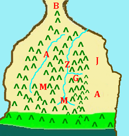
would include the provincial lands of Melek,
and Ammonihah upon the west. Then there would
be Bountiful province and the Capital parts
of the land to the north of Zarahemla local, ant the province of
Manti to the south. Within that side
eastern valley would be the province of Gideon.
And the provincial lands of Jershon and
Antionum to the east, at least until Antionum defected with its land to the Lamanites.
Though the exact form and shape of the land would differ as before that great
day of destruction at the death of the Lord, who is to say just what the
land was like beyond a general relationships of the lands of the nation of
Zarahamela? Now in general this would be the lay of the national lands of
Zarahemla and it provinces from west to east, from top to bottom. And like
how New York has had the city of New York, the county of New York about the
centeral city and then even the greater State of New York, so would there be the capitol
city named Zarahemla with its immediate surrounding county or provincial
land and city, and then there would be the greater nation of Zarahemla which
would include the provincial lands of Melek,
and Ammonihah upon the west. Then there would
be Bountiful province and the Capital parts
of the land to the north of Zarahemla local, ant the province of
Manti to the south. Within that side
eastern valley would be the province of Gideon.
And the provincial lands of Jershon and
Antionum to the east, at least until Antionum defected with its land to the Lamanites.
 Now with that geography laid out, we turn to the very first of the settlement
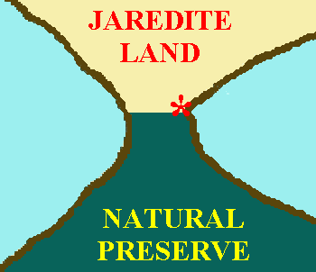
of the lands of Zarahemla. Mulek was first brought to the land north, likely
just north of the narrow neck upon the east coast about the great city of
commerce of the Jaredites. The Phoenicians likely knew and traded with the
Jaredites in their day at that port city. And when considering where to flee
with the son of King Zedekiah to avoid the 'World Empire of Babylon', it is
likely that this was the place that would be the greatest distance form the
Empire of Babylon and therefore considered to be the safest for the heir of
the Jewish crown, Mulek.
Now with that geography laid out, we turn to the very first of the settlement
of the lands of Zarahemla. Mulek was first brought to the land north, likely
just north of the narrow neck upon the east coast about the great city of
commerce of the Jaredites. The Phoenicians likely knew and traded with the
Jaredites in their day at that port city. And when considering where to flee
with the son of King Zedekiah to avoid the 'World Empire of Babylon', it is
likely that this was the place that would be the greatest distance form the
Empire of Babylon and therefore considered to be the safest for the heir of
the Jewish crown, Mulek.
Upon landing at that city of trade, Mulek's party found but totally Desolation
except for finding one last sole of the Jaredites, Coriantumr. After the end
of the great destruction of the Jaredites, Coriantumr would have been all
alone, except perhaps for some who had escaped if any. After regaining his
strength, Coriantumr became a long and lonely search for life. Ether had thought
to have seen the end of Coriantumr though it had been said he would be the
last to remain alive. And whether Coriantumr or Ether ever met after the
final battle is not know. But Coriantumr's search for life carried him from
the far northern reached of Cumorah all the way back down to the exterme
southern region of the Jaredite civilization and that would be at the city
of commerce just to the north of the narrow neck of land.
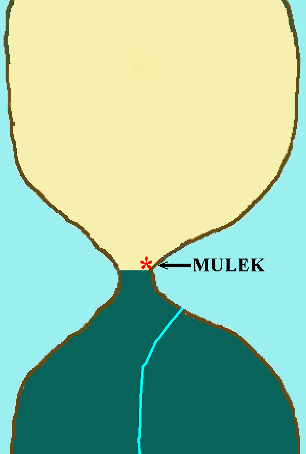 Just what understanding was conveyed which then brought the Mulekites south
and up and into the center of the land south upon the western shore of the
river Sidon is not for sure. Certainly the hand of the Lord was in it (Helaman
6:10). And likely being sailors who conveyed Mulek to this land of 'safety',
they would
sail from that first stop where they found but total desolation except for
Coriantumr. And they would sail along the east coast south until they would
have come upon the mouth of the Sidon river. They could have traveled by land
up into the land, but why when they could continue to sail up the river until
they would reach the center of the land and been completely hid and safe from
the World Empire of Babylon. Most colonist begin upon the coasts. But for
these obvious reasons it would seem that the Mulekites sought exclusion by
first settling in the center of the land some distance from the coasts and
possible discovery.
Just what understanding was conveyed which then brought the Mulekites south
and up and into the center of the land south upon the western shore of the
river Sidon is not for sure. Certainly the hand of the Lord was in it (Helaman
6:10). And likely being sailors who conveyed Mulek to this land of 'safety',
they would
sail from that first stop where they found but total desolation except for
Coriantumr. And they would sail along the east coast south until they would
have come upon the mouth of the Sidon river. They could have traveled by land
up into the land, but why when they could continue to sail up the river until
they would reach the center of the land and been completely hid and safe from
the World Empire of Babylon. Most colonist begin upon the coasts. But for
these obvious reasons it would seem that the Mulekites sought exclusion by
first settling in the center of the land some distance from the coasts and
possible discovery.
Now as stated the Magdalena or Sidon River was from the regions where the
Andes splits into the three Cordillera Ranges of Colombia. All the tributaries
of the eastern central cordilleras and of the western eastern cordillerals
would have provided the Magdalena River with a very great water shed which would
create such a great river. Its long and wide basin or valley lies between
the Central and Oriental Cordillera. Today it flows in a northerly (north by
northeast) direction for about 957 miles to the Caribbean Sea. Today it is
navigable for over half its distance for about 615 miles of its length to the
inland port of Honda from the Carribean coast. The river is the principal
route to the interior of Colombia, and past the rapids at Honda, it is
navigable for another 150 miles. Today, its largest tributary is the Cauca
River which runs parallel to the Magadalena in the western twin valley of the
three cordillera. The city of Barranquilla is the leading seaport of
Colombia today which is situated near the mouth of the Magdalena River.
The Phoenician vessel(s) sailed
up the river which they would name after the port they had departed from in
the old world Zidon or Sidon. The Magdalena River is a navigable river for
over half of its river's length. Why the party of Mulek would want to settle
inland can be speculated upon. The reason would include wanting to insure a
safe haven away from armies of destruction, in a place where they would not
be easily discovered. They had fled from the great destruction of Jerusalem
by Babylon. They had landed in a land that showed vast evidences of a
warring and destruction. They wanted to get away from destructive danger and
of being detected by such forces. Further, they may have been aware of the
principles of colonization, of settling on a river as a clean water source and
away from the limited resources of a coastal environment. Also, while not
bring written records with them, they may have been lead by a man of God. We
do not know all the reasons as the history of the Mulekites is vague in the
Book of Mormon, but they did settle their major cultural and city center in
the center of the land, well away from any of the coastal regions, east, west,
or north.
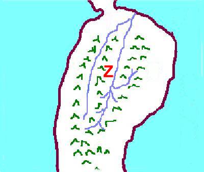
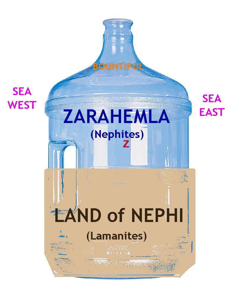 The map at the right presents a rough map of the land of Zarahemla. The
map is not intended to be exact as the lands would change in conjunction with
the great destruction at the time of the death of Christ. Shown here is a
representation of the three mountain ranges of the cordilleras of Colombia.
The shorelines are speculative and make the assertion of a sea existing in
the great Amazon Basin which becomes the Sea East of the Book of Mormon. The
Northern coast of the land is assumed to not be as extensive and as north
beyond the narrow neck as it is today. It is a map that mixes the
generalities of the geography of Colombia matching them with the internal
requirements presented in the Book of Mormon. The main center and city of
this society was located mid-way up the Sidon River and just below a valley
that would veer off to the east that would become know as the Valley of Gideon.
The 'Z' on the map marks the site of this center of Mulek civilization and
the center of their colonization of the land which would become known as the
nation of Zarahemla.
The map at the right presents a rough map of the land of Zarahemla. The
map is not intended to be exact as the lands would change in conjunction with
the great destruction at the time of the death of Christ. Shown here is a
representation of the three mountain ranges of the cordilleras of Colombia.
The shorelines are speculative and make the assertion of a sea existing in
the great Amazon Basin which becomes the Sea East of the Book of Mormon. The
Northern coast of the land is assumed to not be as extensive and as north
beyond the narrow neck as it is today. It is a map that mixes the
generalities of the geography of Colombia matching them with the internal
requirements presented in the Book of Mormon. The main center and city of
this society was located mid-way up the Sidon River and just below a valley
that would veer off to the east that would become know as the Valley of Gideon.
The 'Z' on the map marks the site of this center of Mulek civilization and
the center of their colonization of the land which would become known as the
nation of Zarahemla.
It is important to emphasize that the land was totally wilderness when the
Mulekites first arrived and colonized the land. The only exceptions to the
presence of man in the land excepting the Mulekites would have been the
temporary visits of the Jaredites and the landing of Lehi's party a little
south of the Isthmus of Darien on the west coast. Lehi's party stayed there
only long enough to plant, harvest, and replenish their seeds. Lehi's party
journeyed in the forested wilderness but avoided any contact with the
Mulekites in the Sidon Valley as Lehi's pary traveld south through the
parallel mountain valley of the Cauca River. Lehi's party traveled to the
western coastal area of central to northern Peru where they found a climate
which they where more acustomed to. Both the Mulekites and the Lehites
benefited form the animals of the Jaredites which has wandered into the land
south for the want of food. This was the very first colonization of this
northern portion of the land south since the flood of Noah.
 Note: Science is a subjective thing. According to science there was no
universal flood of Noah and the land though once one land was such only
hundreds of thousands of years ago. So forget anything about what the Bible
says about the land being divided in the days of Peleg. Science presumes
its theories and religion suffers. Yes there was once a great Amazon Sea
which would account for the Sea East of the Book of Mormon and the Andean
Uplift has been going on for thousands upon thousands of years again
according to science. So the land could well have 'changed' but not as
dynamically and 'quick' as the Bible and Book of Mormon would portray
according to science. That is upon the one hand. But let science begin to
speculate about such things as 'global warming' and then the earth becomes
very dynamic and quick changing, such as the predicted rise in sea levels
to again restore the 'Amazon Sea' within but a couple of hundred years
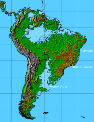
according to science. The graphic of that Amazon Sea reappearing at the right
is one of the more 'conservatively moderate ones' given by science as some
are more dynamic and this is not even to consider such as elevation level
changes due to such events as described in the Book of Mormon which occured
at the time of the death of Jesus Christ. Just imagine the land uplifts taken
away and even a more honest map that takes into consideration that even today
you can sail up the Orinoco river and travel by a natural 'canal' from the
Orinoco River system to the Amazon River system of the Rio Negro and back out
to sea via the Amazon River. Was there once a East Sea upon the east border
of Columbia? YES. Could there be again in short order according to global
warming theorists? YES.
Note: Science is a subjective thing. According to science there was no
universal flood of Noah and the land though once one land was such only
hundreds of thousands of years ago. So forget anything about what the Bible
says about the land being divided in the days of Peleg. Science presumes
its theories and religion suffers. Yes there was once a great Amazon Sea
which would account for the Sea East of the Book of Mormon and the Andean
Uplift has been going on for thousands upon thousands of years again
according to science. So the land could well have 'changed' but not as
dynamically and 'quick' as the Bible and Book of Mormon would portray
according to science. That is upon the one hand. But let science begin to
speculate about such things as 'global warming' and then the earth becomes
very dynamic and quick changing, such as the predicted rise in sea levels
to again restore the 'Amazon Sea' within but a couple of hundred years
according to science. The graphic of that Amazon Sea reappearing at the right
is one of the more 'conservatively moderate ones' given by science as some
are more dynamic and this is not even to consider such as elevation level
changes due to such events as described in the Book of Mormon which occured
at the time of the death of Jesus Christ. Just imagine the land uplifts taken
away and even a more honest map that takes into consideration that even today
you can sail up the Orinoco river and travel by a natural 'canal' from the
Orinoco River system to the Amazon River system of the Rio Negro and back out
to sea via the Amazon River. Was there once a East Sea upon the east border
of Columbia? YES. Could there be again in short order according to global
warming theorists? YES.
[Back to Page 1]
[Forward to Phase 2]