Second Phase of Colonization and Settlement of Zarahemla
(Expansion in the Vast Valley of Sidon - 580-170 BC)
by Don R. Hender
Now that the first logical phase of migration and colonization of the
wilderness of the land south, that is of Zarahemla, had taken place about
580 BC, the next phase would be to expand that orginal colony in the wide and
long river valley of the Sidon river. We know that the Mulekites consisted
of Jews who accompanied the son, Mulek, of King Zedekiah. We know that the
party would have included women and most likely children as well. And there
were most liakely other who had piloted the ship(s) as illustrated by the
Phoenician ship at the left. The Phoenicians were the 'Sea Kings' who had
probably become aware of these possible land of escape in trading with the
Jaredites perhaps as early as the days of King Solomon whose ships of Tarshish
would go sailing for three years at a time before returning with their goods
of trade. Now then we must 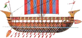 presume that the nature of those who were also a part of Mulek's colony included
those Sidonites or Phoenician sailors and crew of the vessels of this era
including the oarsmen. That prudent planning for thee escape and to keep it
a secretive matter, such wives and families of such crew and oarsmen may well
have been inclued as well. On the open sea the vessel could be propelled by
sail by the wind and up the Sidon river by the labor of its oarsmen in the
lack there of. This brings to mind the likelihood of a multi-racial make up
of Mulek's colony. Surely the crew and perhaps other members of the party of
Mulek were not just Jews of the house of Israel. The artifacts which portray the facial characteristics of
the Pre-Colombian peoples of the Americas support the likelihood of a
multi-racial basis to the nature of Mulek's colony.
presume that the nature of those who were also a part of Mulek's colony included
those Sidonites or Phoenician sailors and crew of the vessels of this era
including the oarsmen. That prudent planning for thee escape and to keep it
a secretive matter, such wives and families of such crew and oarsmen may well
have been inclued as well. On the open sea the vessel could be propelled by
sail by the wind and up the Sidon river by the labor of its oarsmen in the
lack there of. This brings to mind the likelihood of a multi-racial make up
of Mulek's colony. Surely the crew and perhaps other members of the party of
Mulek were not just Jews of the house of Israel. The artifacts which portray the facial characteristics of
the Pre-Colombian peoples of the Americas support the likelihood of a
multi-racial basis to the nature of Mulek's colony.
 The second
map of colonization at the right represents the concept that the second stage
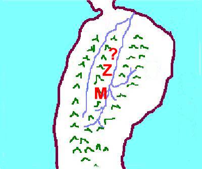
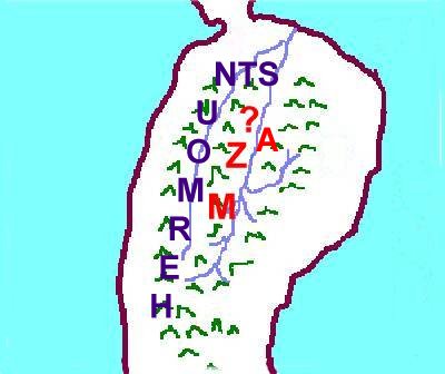
expanded north and south in the valley of Sidon. The only name we have of an adjoining land to the initial city of Zarahemla, is a land known as Minon to the south, further up the Sidon River valley. We do not have from the Book of Mormon a name of the lands and cities north and further down the Sidon, though it is a correct assumption to place them there. Later a Lamanite army, under a Nephite dissenter named Coriantumr, would attempt to fight their way through the cities and lands north of Zarahemla in seeking to reach the narrow neck and the land northward as recorded in Helaman 1. This nameless colonization is represented by the '?' on the map at the right.
The second
map of colonization at the right represents the concept that the second stage
expanded north and south in the valley of Sidon. The only name we have of an adjoining land to the initial city of Zarahemla, is a land known as Minon to the south, further up the Sidon River valley. We do not have from the Book of Mormon a name of the lands and cities north and further down the Sidon, though it is a correct assumption to place them there. Later a Lamanite army, under a Nephite dissenter named Coriantumr, would attempt to fight their way through the cities and lands north of Zarahemla in seeking to reach the narrow neck and the land northward as recorded in Helaman 1. This nameless colonization is represented by the '?' on the map at the right.
Minon is represented by the 'M' on the map at the right. Minon was
further north than the side valley of the Sidon Valley which veered to the
east. The distances can only be estimated, but they were an army's day's
march north. Alma had camped in the valley which would become known as
Gideon in pursuit of the dissenting Nephites. Alma sent spies to see where
the Amlicites had gone. Perhaps Alma had spies travel up the side valley as
well as up the Sidon Valley, not knowing for sure whence they had gone.
Perhaps Alma encamped on the east of the river in the side valley as a means
of protecting and guarding his camp at night against a surprise attach by the
Amlicites. The spies traveled by night and by morning they brought back word
that the Amlicites had joined with an advancing army of Lamanites and were
cutting their way through the land of Minon, destroying the people and
marching on to Zarahemla. Alma was able to march from the Valley of Gideon
and cross the river at a prepared, likely bridged spot, where they could
cut off the advancing armies of the enemy. Alma was successful that evening
in defeating the Lamanites and in the days of pursuit that followed, his army
chased the fleeing enemy into the wilderness of Hermounts to the north and
west of Zarahemla. It would seem that Alma's army position had cut off the
possible retreat back south, up the Sidon Valley.
This is the first indication that the Sidon just did not run north and
south but that it ran from the southwest to the northeast. The fleeing
Lamanites would not have advance upon further enemy cities down the river,
but they did flee north and west into the wilderness. Thus the further
cities of the Sidon Valley where not north, but must lay to the northeast as
the valley ran in that direction but still ran generally north as the fore
cited Coriantumr would fight his way through them down the valley on his
intended march to the narrow neck.
 The river Sidon was a massive river. The practice of the Nephites was to
cast the bodies of the dead of the Lamanites into the river Sidon. The river
Sidon would carry them with no problem of blockages out to the sea many miles
away. This they did with the dead during this battle just described. This
they did later with numberless Lamanites up in the land of Manti near the
headwaters of the Sidon. The Sidon was easily navigable from the sea to the
city of Zarahemla and forceful enough to carry thousands upon thousands of
dead bodies from its head waters all the way down to the ocean. It was no
small stream or limited river that would get clogged by thousands of bodies
drifting down its full course. It was a big strong forceful river from its
head to the ocean with many tributaries flowed into it, keeping its current
strong all along its course from the mountains on the west and the mountians
on the east, the central and oriental cordilleras of Colombia. The Magdalena
River is the Sidon River.
The river Sidon was a massive river. The practice of the Nephites was to
cast the bodies of the dead of the Lamanites into the river Sidon. The river
Sidon would carry them with no problem of blockages out to the sea many miles
away. This they did with the dead during this battle just described. This
they did later with numberless Lamanites up in the land of Manti near the
headwaters of the Sidon. The Sidon was easily navigable from the sea to the
city of Zarahemla and forceful enough to carry thousands upon thousands of
dead bodies from its head waters all the way down to the ocean. It was no
small stream or limited river that would get clogged by thousands of bodies
drifting down its full course. It was a big strong forceful river from its
head to the ocean with many tributaries flowed into it, keeping its current
strong all along its course from the mountains on the west and the mountians
on the east, the central and oriental cordilleras of Colombia. The Magdalena
River is the Sidon River.
Before we leave this second stage of the expansions in the Sidon Valley,
we need to consider a few more items. One is the location of the wilderness Hermounts, another is colonization on the east bank of Sidon in the Sidon Valley, and third is the various meanings and applications of the name Zarahemla. Hermounts is first. It is important to realize that all this new pristine wilderness began as wilderness. In reference to the Zarahemla Valley, and the settlements there, the most wild wilderness was where the wild animals mostly dwelt and that was to the west and north of the Zarahemla Valley, all the way to the mangrove swamps of the west coast and all the way to the narrow neck northward and the land Bountiful. Now Bountiful was still a part of the wilderness at this point. This is seen by the description of Hermounts in Alma 2:37 compared with the description of Bountiful in Alma 22:31. In chapter 2 Hermounts is the wilderness 'infested' with wild and ravenous beasts and in chapter 22, Bountiful is denoted as the wilderness filled with all manner of wild animals of every kind. Not until a later time will Bountiful be settled and cleared, first as a defensive city under Captain Moroni, and then as timber is harvested and shipped to the land north in the first part of Helaman. Thus on the north of Zarahemla the wilderness of Hermounts extents to and includes Bountiful which runs from the sea west to the sea east and up into the narrow neck to a line marking a border with the land of Desolation. The fact that the land was known as 'Bountiful' even while it was still a part of the wild animal wilderness of Hermounts before any settlement, adds some indirect evidence that it was named Bountiful previously by Lehi. It was known by the Nephites to be that 'Bountiful' land region where Lehi's party landed and planted their seeds, reaping a bounteous harvest even before the Nephite nation began to permanently settle the land of Bountiful. They knew this while it was still wilderness.
Next we should consider that there were settlements on the east of Sidon in the Sidon Valley as well as the known ones on the west banks. We know this because when
Amlici organized his followers who had made him King, he organized them on the east of Sidon and prepared for war against the faithful Nephites in that land. We don't have a name given to that land on the east where
Amlici and his people where, but we know it was further north than the valley of Gideon, and that there is a sizable hill named Amnihu, upon which his army assembled as the came from the east to fight with the 'Nephites' of Zarahemla. Thus the 'A' on the second map of this section is for
Amlici or Amnihu and it represents the fact that there is a land settled by people in that area also. But this 'A' will not be shown on other maps as it is not a 'known' named city and thus the '?' mark will continue to represent these cities.
Now the last additional consideration, is the name Zarahemla and what it
means. To begin with, the land and major city may not have historically been called the city and land of Zarahemla before the Nephites, other than the fact that the man Zarahemla, a descendant of Mulek was king in the land when the Mosiah I arrived with his Nephite followers. The name Zarahemla seems to stem from this one source, that is the fact that the King of the Mulekites was named Zarahemla. Now Zaramela could be the city, the immediate land adjoining the city, the rigion, or the entire nation of Zarahemla. It should be noted here that the entire valley of the Sidon River is corretly named as the regional land of Zarahemla. Thus in one sense, all there might have been when Mosiah I entered was Zarahemla and the entire valley nation of Zarahemla and all the rest of the land at that date could have been nothing but unsettled wilderness. Thus when it is said of Alma that he left the land of Zarahemla and traveled west 'over into' the land of Melek, west could mean any where west of the Sidon Riverand the Zarahemla regional valley.
[Back to Page 1]
[Back to Previous Phase 1]
[Forward to Next Phase 3]