Colonization and Settlement of Zarahemla
by Don R. Hender
Background: Patterns of Colonization
We may have no real basis of comparison of the colonization of such as Zarahemla,
a vacant land without any local resistance to having the land freely colonized.
Even in the 'New World' of the Americas, there was resistance to the colonization
effort. That is their were native Americans already in possition of the land. Thus
the parties of Lehi and Muleck had no such resistance, nor has any other such effort
in America been like unto the 'no-resistance' experienced by the Book of Mormon
colonization of the land laid clear by the hand of the Lord.
In the Book of Mormon it but speaks of three colonies, the Jaredite Colony which came
in the time of the Tower of Babel likewise had no such native population resistance
though there is indiations that at some extend the residual waters from the flood and
the dividing of the lands during the days of Peleg were still have marginal effects
upon the land. But by the time of Lehi, the Jaredites had literally self-distructed
about the date of 600 BC to when the Lehi colony arrived about 580 BC. And the Mulekite
in like order, met only on sole survivor, Coriantumr who could only help them in their
colizing of the land when they arrived presumably between 590 to 580 BC as well.
In this study we will be concerned primarially with the Mulek and Lehite colony, which
would not join together until some 300-400 years later, so vast was the land to be
settled that they did not join themselves latter to the surviving 'Nephites' of the
Lehi Colony. That was when the Lamanites first removed the Nephites our of the land
of the southern regions of the land south of the narrow neck, and the Nephites had to
flew to the north, where they found the Mulekites living in the forested lands that
the Lehi colony had first journeyed through to the south to obtain a land more like
that lands that they had been removed from in the eastern hemisphere.
 Unique to the Zarahemla era colonization, per the Book of Mormon, though some
scholars take exception, both the Lehi and Mulek colonies had no living native
American resistance to their colonization and thus they were free to explore
and live practically were they may and all natural resorces were theirs to
call upon. Perhaps this is why both the Lehi and Mulek colonies were sucessful.
Any parallel colonial history of American of record would have such a native
resistence and many of those colonies were not always successful.
Unique to the Zarahemla era colonization, per the Book of Mormon, though some
scholars take exception, both the Lehi and Mulek colonies had no living native
American resistance to their colonization and thus they were free to explore
and live practically were they may and all natural resorces were theirs to
call upon. Perhaps this is why both the Lehi and Mulek colonies were sucessful.
Any parallel colonial history of American of record would have such a native
resistence and many of those colonies were not always successful.
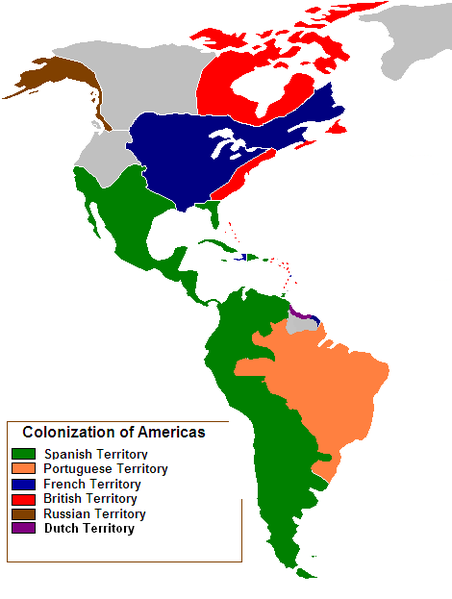
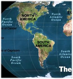
But regardless of native opposition, it is interesting to note the spread of
colonization in the Americas as recorded per the European colonization. From
the Southern European descovery of America by Columbus in 1492 to about 1750,
some 250 years, much of the Americas had been explored and had established
numerous sucessful colonies. The map here provided shows the extent of that
250 years of expansion.
Now while this pattern of colonization is based upon European and Russian
national colonizational attempts and the Book of Mormon relavent colonization
of Zarahemla relates to but one Israelite national colonization of but two
groups, over a period of some 250 years it is of interest to view just how
extensive any such colonizational reaches can be, even in such eras of
'limited' natural means of travel and movement, with many by nothing more
than by foot or meager animal assisted colonization.
Here we see that in some 250 years almost all of South American had been
claimed as explored and colonized by the Spanish, Portuguese, French and
Dutch. All of Central America had been so been claimed as explored and
claimed by the Spanish. And much of North American had been so claimed as
explored and colonized by the French, British, Spanish and Russians.
Now, though having different basis of colonization, it is of interest to see
that great expanses of land and territory may be claimed and lived in which
in itself seems to contradic a notion of a 'limited Book of Mormon region'
of colonization and expansion over 1,000 years. Even the 13 original colonies
of Britain along the eastern shores of the United states, from the time of
their becoming a nation to less than 150 years (1776-1926) later, they did
cover and claim the land from sea to sea. And this with opposition from the
French, Spanish and American Indians.
Now it would also seem that Joseph Smith taught that the Jaredites themselves
did expand to cover such distinctive reaches from sea to sea upon the North
American continent as well which ought not seem unrealistic given the
colonization, exploration and habitation of the Americas during our own
historical times.
"When we read in the Book of Mormon that Jared and his brother
came on to this continent from the confusion and scattering at the Tower, and
lived here more than a thousand years, and covered the whole continent
from sea to sea, with towns and cities; . . ." Times and
Seasons, Vol. 3, No. 22, p. 922, 1842, Editor Joseph Smith
Now there are but two American Continents, North America and South America.
And Joseph Smith was speaking concerning the North American continent, the
same continent which the 'European Colonist' did spread across and inhabit
also. Then indeed why not just the Jaredite nation but the Nephite and
Lamanite nations as well? Some Book of Mormon scholars scoff at such a notion
that spreading across vast reaches of land could just not have happened in
such periods of time as a few hundred years. Yet historical and even 'Book of
Mormon' colonization and expansion would state differently. And thus this
text in its later stages will also so report and consider that the colonies
of Mulek and Lehi did also so spread out rather than to remain so limited in
scope, which limited geography such history so cited does not support nor
confirm.
And Yet a Broader Consideration Still
Now the geography of America and thus the Book of Mormon begins in the
Bible. Through modern revelation, we are given to understand that
 the Land of Adam was in
what is now the central lands of the United States of America, centering around
Spring Hill, Davis County, Adam-ondi-Ahman, and Independence, Missouri. In
the days of Adam, the earth was all one land. Even after the flood of Noah,
though Noah was removed a great distance from the original lands of Adam, the
earth was still one land. Although the American lands of the Nephites before
the land reshaping destruction were significantly diferent from how they
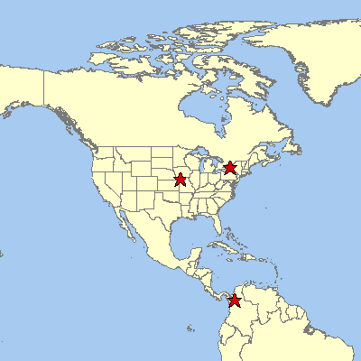
appear today, the three stars on the map at the right represent three proposed
common positions still existing today with the land as it was during the days
of the Nephites before Christ. The star in the center of the United States is
the Land of Adam.
The star in
the state of New York locates the Hill Cumorah or Ramah of the Book of Mormon.
And the star by the narrow neck of the Darien in northern Colombia locates
where Joseph Smith states that Lehi landed in the land of Bountiful of the
nation of Zarahemla. (Teachings of the Prophet Joseph Smith, page 267)
the Land of Adam was in
what is now the central lands of the United States of America, centering around
Spring Hill, Davis County, Adam-ondi-Ahman, and Independence, Missouri. In
the days of Adam, the earth was all one land. Even after the flood of Noah,
though Noah was removed a great distance from the original lands of Adam, the
earth was still one land. Although the American lands of the Nephites before
the land reshaping destruction were significantly diferent from how they
appear today, the three stars on the map at the right represent three proposed
common positions still existing today with the land as it was during the days
of the Nephites before Christ. The star in the center of the United States is
the Land of Adam.
The star in
the state of New York locates the Hill Cumorah or Ramah of the Book of Mormon.
And the star by the narrow neck of the Darien in northern Colombia locates
where Joseph Smith states that Lehi landed in the land of Bountiful of the
nation of Zarahemla. (Teachings of the Prophet Joseph Smith, page 267)
It is understood from the Bible, that after the flood, the people where
commanded by the Lord to disperse and re-populate the earth. "And God blessed
Noah and his sons, and said unto them, Be fruitful, and multiply, and
replenish the earth."(Gen. 9:1) They did not do this! Instead, for the most
part they remained bunched together having one language and of one speech,
being one people.(Gen. 11:1-9) Now the days of Peleg, when the earth was
divided, came and went before the days of the tower of Babel.(Gen. 10:25)
Perhaps it was not only the flood but the shuttering rumblings of the earth
being divided that influenced the poeple to build the great tower towards
heaven.
 The exact shape of the great building is a matter of debate. But
with somewhat limited architectual skills it is easy to consider that their
stucture must have had an ever increasingly large base in order to continually
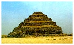
support the ever increasing heighth of the tower. Perhaps it was a pyramidal
type structure. Today we know that Pyramids dot the earth from China to Egypt
to throughout the Americas, north, south and central. Perhaps the first 'step' pyramidal structure of the earth was that
of the great tower of Babel, or at least since the flood of Noah.
In fact, the first pyramids where not built in Egypt though the Egyptians
certainly refined the art of pyramid building to having flat surfaces rather
than step upon step. The pyramid builders in the Americas retained the step
pyramid style. From the days of the Olmec who correlate with the Jaredites,
who the Book of Mormon reports came from the east during the time of the
tower of Bable, to the later days of the Mayan who correlate with the long
span of Lamanite occupation in the land since the distruction of the
Nephites in 385 BC. The Nephites only dwelt in the land for a mere 400 years
compared to 1600 for the Jaredite and over 1700 years for the Lamanite.
The exact shape of the great building is a matter of debate. But
with somewhat limited architectual skills it is easy to consider that their
stucture must have had an ever increasingly large base in order to continually
support the ever increasing heighth of the tower. Perhaps it was a pyramidal
type structure. Today we know that Pyramids dot the earth from China to Egypt
to throughout the Americas, north, south and central. Perhaps the first 'step' pyramidal structure of the earth was that
of the great tower of Babel, or at least since the flood of Noah.
In fact, the first pyramids where not built in Egypt though the Egyptians
certainly refined the art of pyramid building to having flat surfaces rather
than step upon step. The pyramid builders in the Americas retained the step
pyramid style. From the days of the Olmec who correlate with the Jaredites,
who the Book of Mormon reports came from the east during the time of the
tower of Bable, to the later days of the Mayan who correlate with the long
span of Lamanite occupation in the land since the distruction of the
Nephites in 385 BC. The Nephites only dwelt in the land for a mere 400 years
compared to 1600 for the Jaredite and over 1700 years for the Lamanite.
Now back to the old world. During the days of Peleg and the tower of Babel,
the people remained centrally grouped. And they would not disperse upon the
face of the land according to the commandment from God to replenish the earth.
Therefore, they were not to be found upon the lands that had been divided from
the central lands of Babel of the east. For many years these other lands
remained vacant of human life. Various wild animals would have migrated back
before the division of the lands, but man and his domestic animals had not.
They had remained as one united people and instead they began to build a
 great city and a great tower reaching to heaven. Thus the Lord determined to
confound the language and to scatter the people abroad upon the face of all
earth. In order to do this, the people would have to travel the seas to get
to the lands that had been divided in the days of Peleg. So how did the Lord
return or scatter the peoples of the Americas back to the now divided lands
of the Western Hemisphere after the flood of Noah? The Book of Mormon fills
in the answer to this question as it does with many that the Bible leaves
unaddressed.
great city and a great tower reaching to heaven. Thus the Lord determined to
confound the language and to scatter the people abroad upon the face of all
earth. In order to do this, the people would have to travel the seas to get
to the lands that had been divided in the days of Peleg. So how did the Lord
return or scatter the peoples of the Americas back to the now divided lands
of the Western Hemisphere after the flood of Noah? The Book of Mormon fills
in the answer to this question as it does with many that the Bible leaves
unaddressed.
 All Bible students are familiar with the story of the Tower of Babel and
how the Lord confused the peoples' languages or tongues to force a language
barrier which would require them to disperse into smaller groups and begin to
dispurse upon the face of the earth. The Book of Mormon sheds more light and
understanding on this era as it tells of one group of people who heeded the
Lord's warnings and did not want their language confused. Yes, according to
the Book of Mormon, the Lord did not just up and change the language of the
people, he warned them of what he would do. The people of Jared did not want
their language confused. So they prayed and promised to do God's will if he
would not confuse their language. These where the 'Jaredites,' and they were
the first to be brought back or 'scattered' by the hand of the Lord back to
Land of Adam, the promised land of Adam. That story is in the book of Ether
in the Book of Mormon.
All Bible students are familiar with the story of the Tower of Babel and
how the Lord confused the peoples' languages or tongues to force a language
barrier which would require them to disperse into smaller groups and begin to
dispurse upon the face of the earth. The Book of Mormon sheds more light and
understanding on this era as it tells of one group of people who heeded the
Lord's warnings and did not want their language confused. Yes, according to
the Book of Mormon, the Lord did not just up and change the language of the
people, he warned them of what he would do. The people of Jared did not want
their language confused. So they prayed and promised to do God's will if he
would not confuse their language. These where the 'Jaredites,' and they were
the first to be brought back or 'scattered' by the hand of the Lord back to
Land of Adam, the promised land of Adam. That story is in the book of Ether
in the Book of Mormon.
When the Jaredites where brought to replenish and re-populate the 'American'
land, they did so over some 1600 years (2200-600BC). This is plenty of time to
fill all of the land but they did not fill the entire land of the Americas.
They populated all the land of the Americas north of the 'narrow neck of land'
which I've concluded to he the Darien or the Land of Panama. But they did
not permanently inhabit the land south of the neck. They kept the land south
as a natural preserve. The Book of Mormon does not yield adequate information
that would allow one to develop a detailed mapping of the lands of the
Jaredites. And it is just as well, as at the death of Christ, the destruction
in the Americas was so extensive that the entire face of the land north was
altered and changed.(3 Nephi 8:12)
Now to proceed further, the simple basic structure of the lands of the
Book of Mormon need to be set forth. These lands consisted of a land north
and a land south divided by a narrow neck of land. When the group of Lehi was
brought to the land of promise, they where brought into the land south of the
narrow neck of land. It is important to understand that the land south,
though it had been visited by the Jaredites, that it had been kept as a
natural reserve and that no permenant settlements where set up in the land
south of the narrow neck of land. This is important, because it is basic to
understand that the Mulekites and later the Nephites where the first, since
the time of the flood of Noah to colonize and settle the land of Zarahemla.
And just as an animal's trail is followed by early travelers who make it into
a road, and later it becomes the highway and pattern of the course of travel
in the land. So the first colonizing settlements of the people of Zarahemla
as developed primarily by the Nephites of the era from 170 BC to 30 AD, a 200
year period. And that becomes the basic pattern of habitation and
civilization in the land for the future years to come. It is of some
significances that the only body of
information from the Book of Mormon that is available to be used to construct
a relational and rational map of the land is that which is give by Mormon
concerning the land and nation of Zarahemla. The Jaredite lands contain no
relationary detail which allows a map of the land to be prepared. The lands
of the Lamanites, called the land of First Inheritance, the Land of Lehi-Nephi,
and the land of Nephi, does not give adequate relational detail which allows
a map to be made of that land. Only the nation and land of Zarahemla yeilds
adequate information from the pages of the Book of Mormon, which allows the
building of a relational and rational map of the land.
As one casually observes the map of the western hemisphere, and considers
the general notion of a land north, a land south and a narrow neck dividing
 the land, a most obvious deduction comes almost automaticly. It becomes a
most natural assumption to correlate the land north with North America,
the land south with South America, and the narrow neck with the Darien or
Panama neck of land. This is especially true if one considers that the islands
of the Caribean might once have been a part of the land north's mainland
before the great distruction at the death of Christ.
To not appreciate that relationship would almost be like
one not seeing the forest because of the trees. Yet there are problems which
this almost obvious assumption presents in relating it to the lands of the
Book of Mormon and some LDS scholars have resorted to solve these problems by
ignoring the obvious, and building other models of the Book of Mormon
geography which are not so obvious. Yet I find comfort and answers in the
obvious assumptions, with some allowances, which seem to fit all too well the
Geography of the Book of Mormon and the mapping of the Land of Zarahemla. This
by the way has been the most traditionally accepted line of thought concerning
the mapping of the Book of Mormon lands from past LDS authorites. One statement
from the publication of the Times and Seasons attributed to Joseph Smith by
President Joseph Fielding Smith should suffice:
the land, a most obvious deduction comes almost automaticly. It becomes a
most natural assumption to correlate the land north with North America,
the land south with South America, and the narrow neck with the Darien or
Panama neck of land. This is especially true if one considers that the islands
of the Caribean might once have been a part of the land north's mainland
before the great distruction at the death of Christ.
To not appreciate that relationship would almost be like
one not seeing the forest because of the trees. Yet there are problems which
this almost obvious assumption presents in relating it to the lands of the
Book of Mormon and some LDS scholars have resorted to solve these problems by
ignoring the obvious, and building other models of the Book of Mormon
geography which are not so obvious. Yet I find comfort and answers in the
obvious assumptions, with some allowances, which seem to fit all too well the
Geography of the Book of Mormon and the mapping of the Land of Zarahemla. This
by the way has been the most traditionally accepted line of thought concerning
the mapping of the Book of Mormon lands from past LDS authorites. One statement
from the publication of the Times and Seasons attributed to Joseph Smith by
President Joseph Fielding Smith should suffice:
"When we read in the Book of Mormon that Jared and his brother
came on to this continent [North American] from the confusion and scattering
at the Tower, and lived here more than a thousand years, and
covered the
whole continent from sea to sea, with towns and cities; and Lehi went down by the Red Sea to the great
Southern Ocean, and crossed over to this land and landed a little south of the
Isthmus of Darien, . . . " (Times and Seasons, Vol. 3, No. 22, p.
922, 1842, Editor Joseph Smith; Also Teachings of the Prophet Joseph Smith,
p. 267)
Here from one quote a picture of the Book of Mormon over all geography may be
drawn. The Jaredites lived upon the land north of the 'Narrow Neck of Land'
and according to Joseph Smith did expand their dwelling from sea to sea upon
the Northern Continent of America. Joseph Smith also states that Lehi Landed
a little south of the Isthmus of Darien, which isthmus is in the province of
Darien, the Southern most province just above the country of Columbia. Thus
one may conclude that Lehi was brought to the land south of the 'Narrow Neck
of Land' either upon the shores of western Columbia of a 'little
further south'. And thus the nation and land of Zarahemla may be so deduced
to also be immediately just south of the 'Narrow Neck of Land', the Isthmus
of Darien, and that being the land and region of Colombia. Which other
Book of Mormon authorities and general authorites confirm such as George
Reynolds who concluded that the Magadalena River of Columbia was that same
river as the Sidon River in the Book of Mormon. (Concordance of the Book of
Mormon, by George Reynolds, under Sidon, River, p. 633; Dictionary of the
Book of Mormon, by George Reynolds, p. 326; Footnote: Alma 2:15 (g)river
Sidon, Book of Mormon, 1906 Liverpool, Edition [footnotes by Orson Pratt
1879?])
Now, in order to understand Zarahemla's Colonization and Settlement, a
basic
understanding of the land and its features is very beneficial. Thus a simple
map detailing the land and its features is provided below. While it does
not look much like the South America of today, it is representative of
Colombia, Ecuador, and Peru as they were when there was the Great Amazon Sea
with its outlet to the Pacific in the regions of Titicaca. Also, it is
before the great destruction when the collision between the land plates
broken off from Africa of Brazil along the Atlantic ridge meet with the
rising Cauca land plate of the Pacific. Thus the lands are more north and
south than they are today, their elevation is much lower and mountainous
regions not at high, and the distances are a bit less spread out. This is
because the bending and eruptions, mostly in the region of Ecuador, had not
yet occurred. So the land south and the land of Zarahemla was geographically
different though similar to the features of Colombia through Peru today.
Brief Land Explanation
 First the seas are easily explained, thus they are not on the map. The west
sea is the Pacific, the east sea is the Great Amazon Sea, the sea north would
be the Caribbean Sea, and the sea south would be the Titicaca Pacific outlet
of the Amazon Sea. The land features are in part numbered and
explained on the map itself except for the mountainous regions. The
mountains are those of the Andes. In Colombia the Cordillera (mountains) of
the Andes divides into three ranges. The western range is call the
Occidental Cordillera, the central range is called the Central Cordillera,
and the eastern range is called the Oriental Cordillera. They form two wide
and large river valleys, the Cauca River Valley and the Magdalena (Sidon)
River Valley. These rivers have many tributaries. One of these larger
tributaries forms a smaller eastern valley which rises to the Bogota and then
to the plateaus and is a most notable feature.
First the seas are easily explained, thus they are not on the map. The west
sea is the Pacific, the east sea is the Great Amazon Sea, the sea north would
be the Caribbean Sea, and the sea south would be the Titicaca Pacific outlet
of the Amazon Sea. The land features are in part numbered and
explained on the map itself except for the mountainous regions. The
mountains are those of the Andes. In Colombia the Cordillera (mountains) of
the Andes divides into three ranges. The western range is call the
Occidental Cordillera, the central range is called the Central Cordillera,
and the eastern range is called the Oriental Cordillera. They form two wide
and large river valleys, the Cauca River Valley and the Magdalena (Sidon)
River Valley. These rivers have many tributaries. One of these larger
tributaries forms a smaller eastern valley which rises to the Bogota and then
to the plateaus and is a most notable feature.
To any Book of Mormon student, these features begin to have obvious Book
of Mormon geographical significance and relationships. So briefly they are
first the narrow neck of the Isthmus of Darien a little south of which Lehi
lands in a bounteous forested wilderness. The land, he names of Bountiful.
Second the is the significance of the western sea coast being an impenetrable maze of mangrove swamps and marshes, thus it really never comes into play in the logistics of the greater national land of Zarahemla. Third there is the western Cauca valley which would house Melek in the upper regions and Ammonihah, Noah and possibly Sidom in its mid to lower realms . Also this valley is the valley which Lehi's party journeys through to go south to the Land of First Inheritance which is much more climatically suitable for people from the middle east than the rain forest jungle lands of Hermounts the Cordilleras of Colombia. This valley is also the valley which Limhi's party takes by mistake in search for Zarahema and it may be the same mistake that the invading Lamanites made when they
destroyed Ammonihah, thinking it was Zarahemla they destroyed. Fourth, the
Sidon or Magdalena River Valley is the valley which Mulek's party settles,
they likely sail up the navigable river in their Phoenician sailing vessel,
establishing their civilization in the inland center of the land as the city
of Zarahemla. Fifth there is the smaller but significant eastern valley that
leads to Bogota which the followers of Gideon would populate. Sixth there is
the eastern plain, the Orinoco plains, which would end at the edge of the
great eastern Amazon Sea of that earlier date. Seventh, there is the upper
confusing mountainous water shed divide lands which would border Manti at the
head waters of Sidon and represent the narrow strip of land. Eighth, there
would be the western coastal lands of the Land of First Inheritance. This is
were the Lamanites would live the wandering life of the
hunter-scavenger-gatherer in tents and with little clothing.
And finally the ninth area would be the beginning site of Nephi's civilization where Nephi builds a temple like unto Solomon's Temple. This is were civilization begins in Peru and is know as the Chavin civilization though it would have become poluted by Nephite dissenters and the Lamanites who would posses it longest and last.
Now the long paragraph just completed gives a rough correlation of the
suggested map with the Book of Mormon and the known geography and civilizations
of today. While it is impossible to give an accurate picture of exactly how
the Island of Jacob appeared some 2600 years ago, it is felt that this will
give enough of a rough outline to build upon. The next thing to do in
presenting the Colonization and Settlement of Zarahemla is to briefly present
the 'Pre-Phase' or temporary residence phase of the Colonization of Zarahemla
as Lehi did land a little south of the narrow neck in the land of Bountiful
and the Jaredites had frequanted the land though they left it a perserve and
did not permanently reside in it.
Permanent Colonization and Habitation of the Land
The Land South was a pristine land. The Jaredites had kept it as a
national reserve. They did not settle in it. They left it a natural land and
only would venture there on hunting trips or what could be considered safaris.
When the era of change came, there were simultaneous events occurring. The
Jaredites had just ended their wars of self annihilation at Ramah near Niagra
Falls, Lehi and his family were landing just south of the Isthmus of Darien,
and Mulek's party was landing on the eastern coast of North/Central America in their Phoenician sailing vessel, where they found Coriantumr, the last Jaredite survivor.
The land where the Mulekites landed was the land of Desolation. It was
void of life sustaining resources. Shiz had swept the earth clean of life in a scorched earth policy of destruction which left the land void of timber and animal life. The Jaredite animals, which had avoided the destruction that could, had traveled south through the narrow neck to the Land South for the want of food. That is where Lehi and the Mulekites would find them for their use. Now Mulek's party could not stay in the land of desolation. Some how Coriantumr must have been able to communicate with them about the Land South. Given the choice of a sea faring crew of a Phoenician sailing vessel to travel south my a land of Desolation, or by sea, the choice seems automatic, that they would travel south along the eastern coast of Central America until the reached the navigable river, the Magdalena/Sidon, of the land South.
I will now proceed to present 12 phases of Colonization, Settlement and
Civilization expansions in the National Land of Zarahemla.
[Pre-Phase]
[Phase 1]
[Phase 2]
[Phase 3]
[Phase 4]
[Phase 5]
[Phase 6]
[Phase 7]
[Phase 8]
[Phase 9]
[Phase 10]
[Phase 11]
[Phase 12]
[Post-Phase]
Hit Counter:
(REV. 5-21-01)