
Captain Moroni built a number of instant defensive cities to defend the land, and of necesity, this required placiing the cities according to how they would naturally defend the geography of the habitation of the land. Thus we will see the simple southern quarter become skewed to the extreme southern and western quarter, all the way to the western sea as the population relocation in defense of the nation according to its geography dictates. And we will see the simple eastern quarter become the extreme north-eastern quarter, as the necessary defense of the nation due to the loss of Antionum via the Zoramites, and the natural geography of the land requires the extreme north-eastern defense of the narrow-neck of land. Now we do not know the names of all these cities that Moroni had built. We only know the names of those which did come into play in the actual invasion of the Lamanites and the Nephite subsequent defense of their nation. We can assume that there where other cities in this category that remained un-named and un- identified in the pages of Mormon's abridgement. Now these defensive cities can be divided into two regional area, the east and northeast development and the southwest development.
The East and North-Eastern defense included the following known lands and cities of, from east to north, Nephihah, Moroni, Lehi, Morianton, Omner, Gid, Mulek, and Bountiful all marked on the map to the right by their respective letter. Now the Land Bountiful was named by Lehi at the time of his landing there on the west coast about where Hagoth departs. Nephites had been in the land but no major city was established there until Moroni builds the city Bountiful as part of the defense cities. Until this time the land of Bountiful has been a part of the wilderness of wild beast associated with the land encountered by Lehi and later called the wilderness of Hermounts. (See Alma 22:31-32) And though the land had been penetrated and ventured into to the extend that the distance of the line of the narrow neck had been determined to a day and a half journey for a Nephite, later settled conditions would reduce that journey time across the narrows to just a day's travel during Mormon's defense of the region. Thus this land was still a wilderness until the time Moroni has a formal defensive city placed there when we first hear of the city of Bountiful and not just of the land of Bountiful.
The major purposes of the defensive cities of the north and east seem not just to protect the lands of the east and north from the Lamanites, but to explicitly deny the Lamanites access to the lands of the Jaredites north of the narrow neck of land. This was not only a major objective of the Lamanite military thrust and efforts but even the people of the Nephite city of Morianton were seeking passage to the north. After their unjust dispute with the people of Lehi over lands they crossed the less populated plains of Jershon on their attempt to escape into the land north. Their design was cut off by Teancum and his army.
At this point, it seems quite appropriate to remind he reader that dispite the crowded appearance of the map with all these letters representling cities and lands bunched together, side by side on the map, that these cities and their ajoining lands are in fact separated by large distances which allow for wildernesses and plains. For example, though the 'M' for Mulek butts right up next to the 'B' for Bountiful, there is lands of distance between them. When Moroni attempted to call out the Lamanites to battle by his letter of invitation for the Lamanites to come out to battle, he invited them out to battle upon the 'plains' that were between the City of Bountiful and the City of Mulek (Alma 52:20). These where not the same plains of Nephihah and Jershon as can graphically be appreciated by viewing the map. And though not as large as the plains of Nephihah and Jershon, these low land plains of the land between Mulek and Bountiful where still large and extensive enough to be refered to as 'plains.' Thus between the land of Mulek and the land of Bountiful, there was not only a long stretch of sea shore which the Army of Teancum led the Lamanites of Mulek on a long march of decoy towards the Land of Bountiful (Alma 52:21-24 & 27-28), but there was a wilderness of plains flat lands inland also between Boutiful and Mulek which allowed Mormoni's army a more leasurely march across the plains to meet that Lamanite army of Jacob upon the plains where Moroni initially invited them to meet in battle.
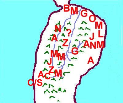
The South-Western defense included the known lands and cities of from the extreme south to the west sea of Manti, Zeezrom, Cumeni, Judea, Antiparah, and the City by the Seashore all marked on the map to the left by their respective letter. This line of defense is quite geographically governed as will be noticed and it begins with an already established outpost or early warning system city in the city and land of Manti. Also, Judea does not appear to be along the defensive southern line as Helamsn's decoy trek went from Judea to the City by the Sea Shore passing by the city of Antiparah which was on the southern defensive line being next to Cumeni.
The areas defensed would be the main accesses to the two major valleys of the cordillers of the Cauca and the Magdalena or Sidon. These two major valleys centers housed most all of the major cities and lands of the Nephites and the major portion of the population. And while the defensive line that Moroni put into place, ran all the way to the Pacific Ocean, there was little concern to actually protect the access to the western coast as it consisted of impenetrable mangrove swamps, murky streamlets, and swamp everglade type lands all the way up the western coast to the land of Bountiful. The only real defensive posture for the City by the Sea Shore on the borders of the land of the Lamanites seems to be to keep the Lamanites from out flanking the Nephites on the west and thus extending the size of the battle front to a size beyond which the Nephites could man and protect.