Land of Lehi's Landing - Geographical Insights
A Short Synopsis - By Don R. Hender
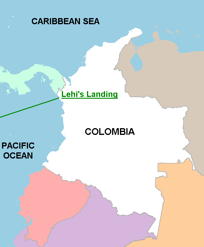

 Despite the prevailing trade winds and ocean currents, which historically
have been used to argue against an Isthmus of Darien landing, the now known
'equatorial countercurrent' that is highly enhanced by the
occasional El Nino storms of an El Nino year with
strong eastward Pacific winds and currents make such a landing totally
possible. (See El Nino link for a suggested route for Lehi's party). Not
only with its initial storminess in the western Pacific, which did quiet
Laman and Lemuel, but with prevailing winds and current it likely drove the
vessel of Lehi across the Pacific in an express time frame and landed them
just south of the Darien Isthmus of Panama as stated by the Prophet Joseph
Smith. This was either on the North
Western shore of Colombia or South Western Shore of South Darien.
Ironically, or by Hagoth's historical awareness and design, this may also have
been the locale of Hagoth's ships departure some nearly 550 years later.
(Alma 63:5-8)
Despite the prevailing trade winds and ocean currents, which historically
have been used to argue against an Isthmus of Darien landing, the now known
'equatorial countercurrent' that is highly enhanced by the
occasional El Nino storms of an El Nino year with
strong eastward Pacific winds and currents make such a landing totally
possible. (See El Nino link for a suggested route for Lehi's party). Not
only with its initial storminess in the western Pacific, which did quiet
Laman and Lemuel, but with prevailing winds and current it likely drove the
vessel of Lehi across the Pacific in an express time frame and landed them
just south of the Darien Isthmus of Panama as stated by the Prophet Joseph
Smith. This was either on the North
Western shore of Colombia or South Western Shore of South Darien.
Ironically, or by Hagoth's historical awareness and design, this may also have
been the locale of Hagoth's ships departure some nearly 550 years later.
(Alma 63:5-8)
 The Book of Mormon lands of Lehi were probably vastly different 600 years
before Christ and the land changing destruction recorded in the Book of Mormon
at his death. The record in the Book of Mormon speaks of land upheavals with
the appearance of a 'great mountain' (3 Nephi 8:10 - possibly the Sierra Nevada
of Santa Marta range with the highest mountain peak in Colombia, Peak
Cristobal Colon.) and other destructions around the time of Christ's death
that changed the whole face of the land northern
and significantly and eventually changed the southern lands as well. This is
'suggestively approximated' and represented by the accompanying map
which also links to the Book of Mormon Geography page.
The Book of Mormon lands of Lehi were probably vastly different 600 years
before Christ and the land changing destruction recorded in the Book of Mormon
at his death. The record in the Book of Mormon speaks of land upheavals with
the appearance of a 'great mountain' (3 Nephi 8:10 - possibly the Sierra Nevada
of Santa Marta range with the highest mountain peak in Colombia, Peak
Cristobal Colon.) and other destructions around the time of Christ's death
that changed the whole face of the land northern
and significantly and eventually changed the southern lands as well. This is
'suggestively approximated' and represented by the accompanying map
which also links to the Book of Mormon Geography page.
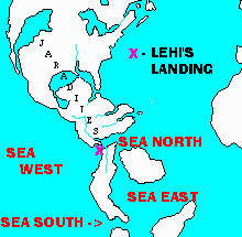
If Lehi was brought by the hand of the Lord into the land south as the Book of Mormon states (Helaman 6:10) and that landing was on the west coast or north Colombia, South America, then the National Lands of Zarahemla and the National Lands of Nephi are to be found in Colombia to Peru. But according to the Book of Mormon, these lands could not have been as wide as all of South America is today. Thus, South America at that juncture of time must have been a land of large South American Islands with the Amazon basin forming what was then the 'East Sea.' This has some support from the Book of Mormon as Lehi's son Jacob reports in the Book of Mormon, that 'we are upon an isle of the sea.'(2 Nephi 10:20) Even in the days of the Spanish explores, when they saw the Amazon river for the first time in the distance from the heights of the Andes, they asked, "Is it a Sea or not?" (See also The Amazon Sea and Me)
Given an Amazon Sea, Lehi's western island was bordered by the Caribbean Sea and Central America on the north, which northern land may have been at that time cut off by invading waters of the El Nino submerging the narrow neck (Ether 10:20). Or perhaps Jacob may not have been aware of the narrow land bridge passage to the North. In the land north, the Jaredites or 'Olmec' were preoccupied with their self annihilation death struggle in the land of Cummorah or Ramah, far removed from Lehi's new colony. On the west of Lehi's island was the great Pacific Ocean, and on the east was the vast Amazon/Orinoco Sea. On the south was the 'Sea of Titicaca,' being part of the western outlet of the Amazon sea to the Pacific. It seems that there where two other islands to the east as they were known by earlier Phoenicians who had left written reference to them. The Phoenicians named one these islands 'Iron Island.' As stated, to the north lay the greater North American island/continent of the Jaredites. This was separated by the narrow neck passage, and as suggested it may have then been inundated by the waters of the El Nino as suggested by the wording of a passage in the book of Ether, chapter 10, verse 20 which states, "And they [speaking of the Jaredites/ Olmec] built a great city by the narrow neck of land, by the place where the sea divides the land.
The land south or 'Lehi's Island,' had first been prepared with the serpent driven, escaping, domestic herds of the Jaredites. (Ether 9:31-33) These domestic herds of 'Lehi's Island' were later joined by other domestic herds which also had migrated there 'for the want of food' during the destruction era, as Jaredite warlord Shiz would sweep the land clean before him in a 'Scorched Earth Policy' during the last great wars of the Jaredite. (Ether 14:18; Alma 22:31) Thus the domestic herds of the Jaredites had become established in the forests and wilderness south of the Darien and in the northwestern (Hermounts) forest wilderness of Colombia. And from thence northern portion of the southern island of Lehi or northern Colombia. (1 Nephi 18:25) Therefore, those domestice animals were there upon Lehi's landing, being provided for use by Lehi's Colony by God's providence.
Not accustomed to forested jungle living, the expedition of Lehi 'journeyed' south to the dryer climate and lands of Peru. And the first civilization there became the people who should be associated with the fully civilized and developed ancient 'Chavin' culture of Peru. They would not return to the northerly Colombian land until well after the tribal split between the Nephites and Lamanites at which time they would find the people of Zarahemla.
The people of Zarahemla, or the other Book of Mormon expedition of this time period, was that of Mulek, son of King Zedekiah. He was the only surviving son of King Zedekiah unknown to Bible historians. Mulek's party landed on the Caribbean coast of the Jaredite northern land. There they found the last liveing Jaredite survivor, Coriantumr who had taken to retracing the course of the Jaredite wars in hopes of finding someone who had survived. In time and perhaps with Corinatumr's aid, Mulek's party left the Jaradite lands of desolation, called by them the Land of Mulek, either by the restored narrow passage to the southern island (as the El Nino had subsided), or by sailing down the coast and up the Magdalena (Sidon) River of Columbia to near Bogota. They settled in the midst of the Magdalena Valley on the west bank of the River Sidon or Magdalena and developed the 'timber' structured, great city of Zarahemla. There they were later joined by Mosiah's Nephites. Mulek's party, coming from the east via the Phoenician's Zidon sea port, named their great water way, the Magdalena River which provided them access to the sea, Sidon.
Another connecting geographical aspect is the twin mountain ranges of the middle and western Cordilleras as the breasts of the land of Colombia. They were called by the Nephites 'Hermounts' which may be a discriptive translation name of 'her-mounts' rather than an actural proper 'Nephite' word. It is of some interest that the 'lost expedition' of the Spanish experienced the same confusion in the vicinity of Manti or 'San Agustin' with the Cauca and Magdalena Valleys as to which mountain valley to take; as did the long traveling Limhi Nephite troop who found the 24 golden plates of Ether the Jardite or 'Olmec' prophet. An extent of the Jaredite or ' Olmec' history and culture is retained from these plates, by way of Coriantumr, and via the Olmec ruins of Central America. These records were translated by Mosiah who held a set of seer stones called the Urim and Thummim. Sounds involved? It should, its real history.
There are many other identifying similarities with the land of Zarahemla and regions of Colombia. One of these is the locations of the known ancient cities and sites of Columbia as presented in the text entitled 'Colombia' by G. Reichel-Dolmatoff. This includes such civilizations as Manti with San Agustin, located at the head waters of Sidon; Ammonihah, the ill fated land and city over the mountain range to which Alma went over to in the Cauca valley; and other western coastal cities associated with those established for defense by Chief Captain Moroni of the military. Another is the location of the Nephite military significant 'plains of eastern Colombia' which correlate with the Book of Mormon noted plains of Nephihah of the Land of Zerahemla. (Alma 52:20; 62:18-19) It further includes the north western 'wilderness' regions of the Mountains of Hermounts to which the Lamanites fled and were devoured by the wild beast. It is also this 'fruitful' northern area or just beyond, that is noted as the land of Bountiful located by the Narrow Neck of Land. And there are other similarities which identify Colombia as the old Zerahemla of the middle ages of the Book of Mormon.
A final logical note of identification of the land of Colombia as being Zarahemla and not that of the land of Central America, is that when the Nephites first began to expand into the land north, they had to build with cement and stone. To the Nephites, this was unusual and worthy of mention as the land from which they came was well forested and they primarily built with wood. It was more customary for them to build with wood so their departure from this norm was well stated in the Book of Mormon. In the land north (Central America) they practiced conservation. They built with stone and shipped in wood for some building, and allowed whatever trees they could to grow to replace those lost to the desolation of Shiz. Thus in Central America we have grand stone and cement built cities with temples and pyramids throughout all of Central America as built by the Nephites during the 200 years of continual peace. Later of course these were occupied, built and reconditioned by those who later dissented back to being Lamanites of which desends the Mayan today. (Not all of North America was left completely desolate of trees. One noted Nephite migrating party is told to have traveled so far extremely north to have found the line where the Desolation of Shiz evidentaly had ended and had found forested lands again.)
Paragraph 2 - See 'El Nino' Weather Condition Information; "American Indians In The Pacific", by Thor Heyerdahl; 2 Nephi 18, Alma 63.
Paragraph 3 - "A Marvelous Work and A Wonder" by LeGrand Richards, 1976 Ed., pages 74-76. Washoe Indian Legend. Helaman 14; 3 Nephi 8 & 9.
Paragraph 4-6 - 2 Nephi 10:20-21 'we are upon the isles of the sea' Jacob's reference, "The Book and the Map" by Venice Priddis, 1975, pages 10, 46-47, 72-73, etc. National Geographic The Amazon and various articles. Omni 1, 2 Nephi 18, Ether 9.
Paragrah 7 - Mosiah 8 & 28, Alma 2; "Colombia" by G. Reichel-Dolmatoff; Other Spanish exploration histories.
Etc.
E-Mail: hunterscastle@gmail.com
TALK TO ME VIA THIS E-MAIL LINK
(Revised: October 6, 2013)